Related Research Articles

Tanzania comprises many lakes, national parks, and Africa's highest point, Mount Kilimanjaro. Northeast Tanzania is mountainous, while the central area is part of a large plateau covered in grasslands. The country also contains the southern portion of Lake Victoria on its northern border with Uganda and Kenya.

Malawi is a landlocked country in southeast Africa. It is wholly within the tropics; from about 9°30S at its northernmost point to about 17°S at the southernmost tip. The country occupies a thin strip of land between Zambia and Mozambique, extending southwards into Mozambique along the valley of the Shire River. In the north and north east it also shares a border with Tanzania. Malawi is connected by rail to the Mozambican ports of Nacala and Beira. It lies between latitudes 9° and 18°S, and longitudes 32° and 36°E.

The British Central Africa Protectorate (BCA) was a British protectorate proclaimed in 1889 and ratified in 1891 that occupied the same area as present-day Malawi: it was renamed Nyasaland in 1907. British interest in the area arose from visits made by David Livingstone from 1858 onward during his exploration of the Zambezi area. This encouraged missionary activity that started in the 1860s, undertaken by the Universities' Mission to Central Africa, the Church of Scotland and the Free Church of Scotland, and which was followed by a small number of settlers. The Portuguese government attempted to claim much of the area in which the missionaries and settlers operated, but this was disputed by the British government. To forestall a Portuguese expedition claiming effective occupation, a protectorate was proclaimed, first over the south of this area, then over the whole of it in 1889. After negotiations with the Portuguese and German governments on its boundaries, the protectorate was formally ratified by the British government in May 1891.

Mulanje, formerly called Mlanje, is a town in the Southern Region of Malawi, close to the border with Mozambique, to the east. It is near the Mulanje Massif.

Nsanje is the main city in Nsanje District within the Southern Region of Malawi.
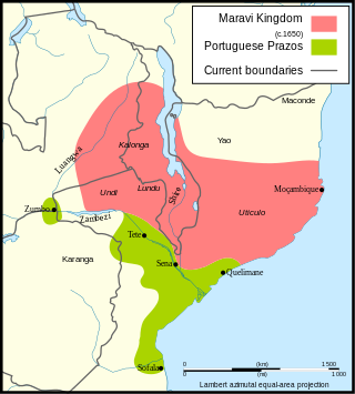
Maravi was a kingdom which straddled the current borders of Malawi, Mozambique, and Zambia, in the 16th century. The present-day name "Maláŵi" is said to derive from the Chewa word malaŵí, which means "flames". "Maravi" is a general name of the peoples of Malawi, eastern Zambia, and northeastern Mozambique. The Chewa language, which is also referred to as Nyanja, Chinyanja or Chichewa, and is spoken in southern and central Malawi, in Zambia and to some extent in Mozambique, is the main language that emerged from this empire.

Alexandre Alberto da Rocha de Serpa Pinto, Viscount of Serpa Pinto was a Portuguese explorer of southern Africa and a colonial administrator.

Lichinga is the capital city of Niassa Province of Mozambique. It lies on the Lichinga Plateau at an altitude of 1,360 metres (4,460 ft), east of Lake Niassa. The town was founded as Vila Cabral as a farming and military settlement. It is served by Lichinga Airport. The province borders Ruvuma Region in Tanzania.

The 1890 British Ultimatum was an ultimatum by the British government delivered on 11 January 1890 to the Kingdom of Portugal. Portugal had attempted to claim a large area of land between its colonies of Mozambique and Angola including most of present-day Zimbabwe and Zambia and a large part of Malawi, which had been included in Portugal's "Rose-coloured Map". The ultimatum led to the withdrawal of Portuguese forces from areas which had been claimed by Portugal on the basis of Portuguese exploration in the era, but which Britain claimed on the basis of uti possidetis.
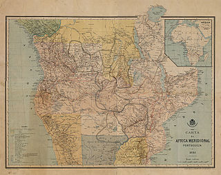
The Pink Map, also known as the Rose-Coloured Map, was a map prepared in 1885 to represent the Kingdom of Portugal's claim of sovereignty over a land corridor connecting the Portuguese colonies of Angola and Mozambique during the Scramble for Africa. The area claimed included most of modern-day Zimbabwe and large parts of modern-day Zambia and Malawi.
Morrumbala District is a district of Zambezia Province in Mozambique. The town of Morrumbala is the district headquarters.
Railway stations in Mozambique include:
Bangula is a town of about 5000 population in southern region district of Nsanje in Malawi. There is also a commune of the same name. Its elevation is 100m. It is located on the western bank of the Shire River, near the confluence of the Shire and Ruo River. After extensive flooding in Chiromo, the municipalities were moved to Bangula. The name Bangula is roughly translated to 'place where the lions roar' – although few to no lions exist in the area anymore.
Sandama is a small town in south central Malawi. To the immediate east is a border with Mozambique.
Ruo River is the largest tributary of the Shire River in southern Malawi and Mozambique. It originates from the Mulanje Massif (Malawi) and forms 80 km (50 mi) of the Malawi-Mozambique border. It joins the Shire River at Chiromo.
Mwanza is a town in Malawi on the border with Mozambique. It is the administrative headquarters for Mwanza District.
Milange is a town in Zambezia Province of Mozambique. It is the district center of Milange District.
The Muloza–Chiringa Road is a road in the Southern Region of Malawi, connecting the towns of Muloza in Mulanje District, and Chiringa, in Phalombe District.

Sena railway, also called Shire Highlands railway, Dondo-Malawi railway and North-South Malawi railway, is a railway that connects Dondo, Mozambique, to Chipata, in Zambia. It is c. 1000 km long, in a 1067 mm gauge.
The Ruo–Ndiza Hydroelectric Power Station is an operational 8.25 megawatts (11,063 hp) hydroelectric power plant in southeastern Malawi, at the border with Mozambique.
References
- ↑ Sabbatini, Mario. "Life with Father". The Society of Malawi Journal. 40 (2): 30–38.
- ↑ "ESIA Baseline Report" (PDF). svtp.gov.mw. p. 29. Archived from the original (PDF) on August 13, 2021.
16°28′00″S35°14′00″E / 16.46667°S 35.23333°E
| | This Malawi location article is a stub. You can help Wikipedia by expanding it. |