
A sinkhole is a depression or hole in the ground caused by some form of collapse of the surface layer. The term is sometimes used to refer to doline, enclosed depressions that are also known as shakeholes, and to openings where surface water enters into underground passages known as ponor, swallow hole or swallet. A cenote is a type of sinkhole that exposes groundwater underneath. Sink, and stream sink are more general terms for sites that drain surface water, possibly by infiltration into sediment or crumbled rock.
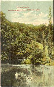
The Aachtopf is Germany's biggest karst spring, south of the western end of the Swabian Jura near the town of Aach. It produces an average of 8,500 litres per second. Most of the water stems from the River Danube where it disappears underground at the Danube Sinkhole, 12 kilometres (7.5 mi) north near Immendingen and about 14 kilometres (8.7 mi) north near Fridingen. The cave system has been explored since the 1960s, but as of 2020 only a small part has been discovered due to a large blockage after a few hundred metres.

The Li River or Li Jiang is the name for the upper reaches of the Gui River in northeastern Guangxi, China. It is part of the Xijiang River system in the Pearl River basin, flowing 164 kilometres (102 mi) from Xing'an County to Pingle County.

Harwoods Hole is a cave system located in the northwest of the South Island of New Zealand, in the Abel Tasman National Park. At 183 metres (600 ft), it is New Zealand's deepest vertical shaft. It was first explored in 1958, long after it was discovered.

A cenote is a natural pit, or sinkhole, resulting when a collapse of limestone bedrock exposes groundwater. The term originated on the Yucatán Peninsula of Mexico, where the ancient Maya commonly used cenotes for water supplies, and occasionally for sacrificial offerings. The name derives from a word used by the lowland Yucatec Maya—tsʼonoʼot—to refer to any location with accessible groundwater.

The Jeita Grotto is a system of two separate, but interconnected, karstic limestone caves spanning an overall length of nearly 9 kilometres (5.6 mi). The caves are situated in the Nahr al-Kalb river valley within the locality of Jeita, 18 kilometres (11 mi) north of the Lebanese capital Beirut. Though inhabited in prehistoric times, the lower cave was not rediscovered until 1836 by Reverend William Thomson; it can only be visited by boat since it channels an underground river that provides fresh drinking water to more than a million Lebanese.

Wes Skiles Peacock Springs State Park is a 733-acre (297 ha) Florida State Park located on Peacock Springs Road, two miles (3 km) east of Luraville and on State Road 51, 16 miles (26 km) southwest of Live Oak, Florida. Activities include picnicking, swimming and diving, and wildlife viewing. Among the wildlife of the park are deer, bobcats, raccoon, squirrels, beaver and otters, as well as turkey, blue heron and barred owls. The park name commemorates the work of diver and explorer Wes Skiles. Prior to 2010 the park was known as Peacock Springs State Park. Amenities include a nature trail, six sinkholes, and Peacock and Bonnet Springs, with miles of underwater caves popular with cave divers. The two springs are tributaries of the Suwannee River. The park is open from 8:00 am till sundown year round.

Zacatón is a thermal water-filled sinkhole belonging to the Zacatón system – a group of unusual karst features located in Aldama Municipality near the Sierra de Tamaulipas in the northeastern state of Tamaulipas, Mexico. At a total depth of 339 meters (1,112 ft), it is one of the deepest known water-filled sinkholes in the world.
Red Lake is a sinkhole containing a karst lake near the city of Imotski, Croatia. It is known for its numerous caves and high cliffs, reaching over 241 metres (791 ft) above normal water level and continuing below the water level. The total explored depth of this sinkhole is approximately 530 metres (1,740 ft) with a volume of roughly 25–30 million cubic metres, thus it is the third largest sinkhole in the world. Water drains out of the basin through underground waterways that descend below the level of the lake floor. The deepest known point of the lake is 4 metres (13 ft) below sea level.

Piccaninnie Ponds Conservation Park, formerly the Piccaninnie Ponds National Park, is a protected area of 862 hectares located in southeastern South Australia near Mount Gambier.

The Bullenkuhle is a predominantly marshy lake in the extreme north of the district of Gifhorn in the north German state of Lower Saxony. This strange biotope and geotope has been formed into a natural hollow in the terrain that is termed a sinkhole. The area is environmentally protected.

Fengshan County is a county of Guangxi, China. It is under the administration of Hechi City.

Cennet and Cehennem are the names of two large sinkholes in the Taurus Mountains, in Mersin Province, Turkey. The sinkholes are among the tourist attractions of the province.
Hranice Abyss is the deepest flooded pit cave in the world. It is a karst sinkhole near the town of Hranice, Czech Republic. The greatest confirmed depth is 519.5 m (1,704 ft), of which 450 m (1,476 ft) is underwater. In 2020, a scientific expedition to the cave revealed that part of the system apparently reaches 1,000 metres (3,300 ft) deep, albeit with the lowest reaches sediment-filled. Analysis of the water found carbon and helium isotopes which implied that the cave has been formed by acidic waters, heated by the mantle, welling up from below.

Dragon's Breath Cave is a flooded karst cave located in the Otjozondjupa Region of Namibia on private land, not accessible to the general public. The cave was discovered by Roger Ellis during a caving expedition to the area in 1986. It is named for the warm moist air that rises from its entrance when barometric pressure drops, which condenses to form a mist suggestive of the breath of a dragon.
Little Blue Lake is a water-filled sinkhole (“cenote”) in the Australian state of South Australia located in the state's south-east in the locality of Mount Schank about 20 kilometres (12 mi) south of the municipal seat of Mount Gambier. It is notable locally as a swimming hole and nationally as a cave diving site. It is managed by the District Council of Grant and has been developed as a recreational and tourism venue.

Fossil Cave (5L81), formerly known as The Green Waterhole, is a cave in the Limestone Coast region of south-eastern South Australia. It is located in the gazetted locality of Tantanoola about 22 kilometres north-west of the city of Mount Gambier, only a few metres from the Princes Highway between Mount Gambier and Millicent. It is popular with cave divers and is notable for being both a unique paleontological site and the "type locality" for very rare crustaceans which to date have been found only in caves and Blue Lake in the Mount Gambier region.
The 1973 Mount Gambier cave diving accident was a scuba diving incident on 28 May 1973 at a flooded sinkhole known as "The Shaft" near Mount Gambier in South Australia. The incident claimed the lives of four recreational scuba divers: siblings Stephen and Christine M. Millott, Gordon G. Roberts, and John H. Bockerman. The four divers explored beyond their own planned limits, without the use of a guideline, and subsequently became lost, eventually exhausting their breathing air and drowning, with their bodies all recovered over the next year. To date, they are the only known fatalities at the site. Four other divers from the same group survived.

Cave diving is underwater diving in water-filled caves. The equipment used varies depending on the circumstances, and ranges from breath hold to surface supplied, but almost all cave diving is done using scuba equipment, often in specialised configurations with redundancies such as sidemount or backmounted twinset. Recreational cave diving is generally considered to be a type of technical diving due to the lack of a free surface during large parts of the dive, and often involves planned decompression stops. A distinction is made by recreational diver training agencies between cave diving and cavern diving, where cavern diving is deemed to be diving in those parts of a cave where the exit to open water can be seen by natural light. An arbitrary distance limit to the open water surface may also be specified. Despite the risks, water-filled caves attract scuba divers, cavers, and speleologists due to their often unexplored nature, and present divers with a technical diving challenge.


