| Sant Corneli | |
|---|---|
 | |
| Highest point | |
| Elevation | 1,351 m (4,432 ft) |
| Geography | |
| Location | Catalonia, Spain |
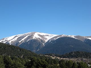
Sant Corneli is a mountain of Catalonia, Spain. It has an elevation of 1,351 metres above sea level. [1]
| Sant Corneli | |
|---|---|
| | |
| Highest point | |
| Elevation | 1,351 m (4,432 ft) |
| Geography | |
| Location | Catalonia, Spain |
Sant Corneli is a mountain of Catalonia, Spain. It has an elevation of 1,351 metres above sea level. [1]

Pallars Jussà is a comarca (county) in Alt Pirineu, Catalonia, Spain. It was established as a comarca in 1936, out of the old county of Pallars. The name is an archaism meaning "Lower Pallars"; to the northeast and into the mountains is Pallars Sobirà. Its capital and largest municipality is Tremp.

C-16 or Eix del Llobregat is a primary highway in Catalonia, Spain. It is also part of the European route E9, from Orléans (France) to Barcelona.

Alt Pirineu is one of the eight regions (vegueries) defined by the Regional Plan of Catalonia. Located in the north-west of Catalonia, specifically by the Pyrenees, it covers the higher mountain regions from the Aragon border to Cerdanya. It is the least populated region, with 63,892 inhabitants as of 2022.

The following outline is provided as an overview of and topical guide to Catalonia:

Montsent de Pallars is a mountain of Catalonia, Spain. Located in the Pyrenees, it has an altitude of 2883 metres above sea level.

Cim del Mont-roig is a mountain of Catalonia, Spain. Located in the Pyrenees, it has an altitude of 2846 metres above sea level.

Monturull is a mountain of Catalonia, Spain. Located in the Pyrenees, it has an elevation of 2,761 metres above sea level.
La Carabassa is a mountain of Catalonia, Spain. Located in the Pyrenees, it has an altitude of 2736 metres above sea level.
Puig d'Ombriaga is a mountain of Catalonia, Spain. Located in the Pyrenees, it has an elevation of 2,638 metres above sea level.
Torreta de Cadí is a mountain of Catalonia, Spain. It has an elevation of 2,561 metres above sea level.

Puig de Dòrria is a mountain of Catalonia, Spain. Located in the Pyrenees, it has an elevation of 2,547 metres (8,356 ft) above sea level.

Puigllançada is a mountain of Catalonia, Spain. Located in the Pyrenees, it has an elevation of 2,409 metres above sea level.

Cap del Verd is a mountain of Catalonia, Spain. It has an elevation of 2,283 metres above sea level.

Puig Cornador (Ribes de Freser) is a mountain of Catalonia, Spain. It has an elevation of 1,799 metres above sea level.
El Coscollet is a mountain in Catalonia, Spain. It has an elevation of 1,610 metres (5,280 ft) above sea level.
El Cogul (Navès) is a mountain of Catalonia, Spain. It has an elevation of 1,526 metres above sea level.

Puig de l'Àliga is a mountain of Catalonia, Spain. It has an elevation of 1,344 metres above sea level.
Puig Cornador (Les Llosses) is a mountain of Catalonia, Spain. It has an elevation of 1,229 metres (4,032 ft) above sea level.

Puigsallança is a mountain of Catalonia, Spain. It has an elevation of 1,026 metres above sea level.
Puig Sesarques is a mountain of Catalonia, Spain. It has an elevation of 880 metres above sea level.
42°10′54″N1°01′49″E / 42.1817°N 1.0303°E
| | This article about a location in Catalonia is a stub. You can help Wikipedia by expanding it. |