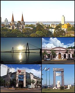
Posadas is the capital city of the Argentine province of Misiones, in its south, at the far north-east of the country on the left bank of the Paraná River, opposite Encarnación, Paraguay. The city has an area of 965 square kilometres (373 sq mi) and a population of 324,756, and the Greater Posadas area has a population of over 359,609 according to a 2017 estimate.

Reducción de Santa María la Mayor, located in the Santa María Department of the Misiones Province, Argentina, at approximate coordinates 27°33′S55°20′W, was one of the missions or reductions founded in the 17th century by the Jesuits in the Americas during the Spanish colonial period. In 1984 it was one of four reduction sites in Argentina designated as World Heritage Sites by UNESCO.

The National University of Misiones is a public university in Argentina; founded by the law 20.286 on April 16, 1973, as part of the Taquini plan, a program of reorganization of the top education that would take the foundation of universities of Jujuy, La Pampa, Lomas de Zamora, Entre Ríos, Luján, Catamarca, Salta, San Juan, San Luis y Santiago del Estero, form to more than 11.000 pupils, between them numerous foreigners, given their border location with Paraguay and Brazil. It has a publishing house and a radio station, LRH301 FM Universidad Nacional de Misiones, that streams in Ogg Vorbis format.
Aristóbulo del Valle (Misiones) is a village and municipality in Misiones Province in north-eastern Argentina.
Arroyo del Medio (Misiones) is a village and municipality in Misiones Province in north-eastern Argentina.
Cerro Corá (Misiones) is a village and municipality in Misiones Province in north-eastern Argentina.
Concepción de la Sierra is a village and municipality in Misiones Province in north-eastern Argentina. The town sits on the original location of the Jesuit Reduction, founded in 1619. The Jesuit heritage is still visible. The Jesuits were expelled from the Spanish Empire in 1767.
Fachinal (Misiones) is a village and municipality in Misiones Province in north-eastern Argentina.
Florentino Ameghino (Misiones) is a village and municipality in Misiones Province in north-eastern Argentina.
Garupá is a village and municipality in Misiones Province in north-eastern Argentina. It takes part of the Great Posadas, and most of the population works in the provincial capital.
General Alvear (Misiones) is a village and municipality in Misiones Province in north-eastern Argentina.
Guaraní (Misiones) is a village and municipality in Misiones Province in north-eastern Argentina.
Hipólito Yrigoyen (Misiones) is a village and municipality in Misiones Province in north-eastern Argentina.

Jardín América is a village and municipality in Misiones Province in north-eastern Argentina. It is not the head city of the San Ignacio department, however, it is the largest city in the department. It is located 1.141 km north of Buenos Aires and 104 km from Posadas, on the eastern shore of the Paraná River.
Loreto (Misiones) is a village and municipality in Misiones Province in north-eastern Argentina.
San Ignacio is a town and municipality in Misiones Province in north-eastern Argentina.
San Javier is a village and municipality in Misiones Province in north-eastern Argentina.
Santa María (Misiones) is a village and municipality in Misiones Province in north-eastern Argentina.
Tres Capones is a village and municipality in Misiones Province in north-eastern Argentina. The town lies at the intersection of two gravel roads: Provincial Road No. 2, which connects the west and east Concepción de la Sierra, and Route No. 202. The municipality has a population of 1,234 people, according to the census of 2001