
Entre Ríos is a central province of Argentina, located in the Mesopotamia region. It borders the provinces of Buenos Aires (south), Corrientes (north) and Santa Fe (west), and Uruguay in the east.

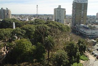
Paraná is the capital city of the Argentine province Entre Ríos, located on the eastern shore of the Paraná River, opposite the city of Santa Fe, capital of the neighbouring Santa Fe Province. The city has a population of 247,863.
Zárate is a port city in the northeast of the province of Buenos Aires, Argentina. It lies on the western shore of the Paraná River, 90 km (56 mi) from Buenos Aires. Its population as per the 2001 census [INDEC] is 101,271 inhabitants. It is the headquarters for and the only city in the partido of the same name.

Victoria is a city located in the southwestern part of the province of Entre Ríos, Argentina. It is located on the eastern shore of the Paraná River, opposite Rosario, Santa Fe, to which it has been connected since 2003 by the Rosario-Victoria Bridge.

San Nicolás de los Arroyos is a city in the province of Buenos Aires, Argentina, on the western shore of the Paraná River, 61 km (38 mi) from Rosario. It has about 133,000 inhabitants. It is the administrative seat of the partido of the same name. It is sometimes called Ciudad de María due to a series of Marian apparitions that led to the erection of the Sanctuary in honor of Our Lady of the Rosary of San Nicolás that began during the 1980s and were approved by Bishop Cardelli of the diocese as "worthy of belief" in 2016.
Concepción del Uruguay is a city in Argentina.

Gualeguay is a city in the province of Entre Ríos, Argentina, on the Gualeguay River, about 226 km from the provincial capital Paraná and 234 km north-west from Buenos Aires. It has a population of about 39,000 inhabitants as per the 2001 census [INDEC]. It should not be confused with Gualeguaychú.

La Paz is a city in the province of Entre Ríos in the Argentine Mesopotamia. It has about 24,000 inhabitants as per the 2010 census [INDEC], and is the head town of the department of the same name.
Villaguay is a city in the province of Entre Ríos in the Argentine Mesopotamia. It has about 49,000 inhabitants as of the census 2010 and is the head town of the department of the same name.
Crespo is a city in the Argentine province of Entre Ríos, some 40 km from the provincial capital Paraná. It has around 19,500 inhabitants, most of whom are descendants of Volga Germans who migrated from Russia to Argentina from 1875 onwards. The town's German heritage is reflected in the annual beer festival, based on the Oktoberfest but held in January. The economy is centered in avicultural and other agricultural products.
Diamante is a city in the west of the province of Entre Ríos, Argentina, on the eastern shore of the Paraná River. It has about 20,000 inhabitants as per the 2010 census [INDEC]. It is the head town of the Diamante Department.

The Constitución Department is an administrative subdivision (departamento) of the province of Santa Fe, Argentina. It is located on the south of the province. It has about 83,000 inhabitants as per the 2001 census [INDEC]. Its head town is the city of Villa Constitución.
The Garay Department is an administrative subdivision (departamento) of the province of Santa Fe, Argentina. It is located in the center-east of the province. It has about 20,000 inhabitants as per the 2001 census [INDEC]. Its head town is the city of Helvecia. It is the least populated in the province.
Rosario del Tala is a city in the center-south of the province of Entre Ríos, Argentina. It has 12,801 inhabitants as per the 2010 census [INDEC], and is the head town of the Tala Department. It lies on the western banks of the Gualeguay River, 179 km east-southeast from the provincial capital Paraná and 118 km due west from Colón.

Nogoyá is a city in the province of Entre Ríos, Argentina. It has 22,824 inhabitants per the 2010 census [INDEC] and is the head town of the Nogoyá Department. It lies in the southwest of the province, by the Nogoyá Stream, about 95 km southeast from the provincial capital Paraná, on National Route 12.

Federal is a city in the province of Entre Ríos, Argentina. It had 16,075 inhabitants per the 2010 census [INDEC], and is the head town of the Federal Department. It lies in the center-north of the province, by National Route 127, about 190 km northeast of the provincial capital Paraná.
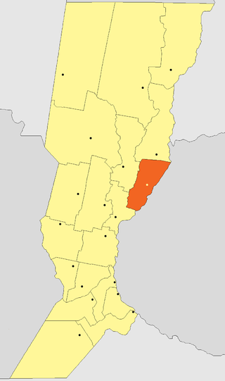
San Salvador is a city in the province of Entre Ríos, Argentina. It has 13,228 inhabitants per the 2010 census [INDEC], and is the head town of the San Salvador Department. It is located on the center-east of the province, by National Route 18, about 48 km west of the Uruguay River and 205 km east from the provincial capital Paraná. The city is known as the 'National Capital of Rice'.

Chajarí is a city in the northeast of the province of Entre Ríos, Argentina. It has 45.000 inhabitants per the 2010 census [INDEC], and it is the largest city in the Federación Department. It lies on Provincial Route 2, about 2 km east of the intersection with National Route 14 and west of the Salto Grande reservoir on the Uruguay River, 330 km from the provincial capital Paraná.
Viale is a town in the west of the province of Entre Ríos, Argentina. It is located about 50 km east from the provincial capital Paraná.

The Entre Rios Rugby Union is the organisational body that governs the game of rugby union in Entre Ríos Province, Argentina. It is headquartered in the city of Paraná.
