Related Research Articles

Monterey Bay is a bay of the Pacific Ocean located on the coast of the U.S. state of California, south of the San Francisco Bay Area. San Francisco itself is further north along the coast, by about 75 miles, accessible via CA 1 and US 101.

Whale watching is the practice of observing whales and dolphins (cetaceans) in their natural habitat. Whale watching is mostly a recreational activity, but it can also serve scientific and/or educational purposes. A study prepared for International Fund for Animal Welfare in 2009 estimated that 13 million people went whale watching globally in 2008. Whale watching generates $2.1 billion per annum in tourism revenue worldwide, employing around 13,000 workers. The size and rapid growth of the industry has led to complex and continuing debates with the whaling industry about the best use of whales as a natural resource.

The four-toothed whales or giant beaked whales are beaked whales in the genus Berardius. They include Arnoux's beaked whale in cold Southern Hemispheric waters, and Baird's beaked whale in the cold temperate waters of the North Pacific. A third species, Sato's beaked whale, was distinguished from B. bairdii in the 2010s.

The false killer whale is a species of oceanic dolphin that is the only extant representative of the genus Pseudorca. It is found in oceans worldwide but mainly in tropical regions. It was first described in 1846 as a species of porpoise based on a skull, which was revised when the first carcasses were observed in 1861. The name "false killer whale" comes from having a skull similar to the orca, or killer whale.

The pygmy killer whale is a poorly known and rarely seen oceanic dolphin. It is the only species in the genus Feresa. It derives its common name from sharing some physical characteristics with the orca, also known as the killer whale. It is the smallest cetacean species that has the word "whale" in its common name. Although the species has been known to be extremely aggressive in captivity, this aggressive behavior has not been observed in the wild.

The southern right whale dolphin is a small and slender species of cetacean, found in cool waters of the Southern Hemisphere. It is one of two species of right whale dolphin. This genus is characterized by the lack of a dorsal fin. The other species, the northern right whale dolphin, is found in deep oceans of the Northern Hemisphere and has a different pigmentation pattern than the southern right whale dolphin.

The Otago Peninsula is a long, hilly indented finger of land that forms the easternmost part of Dunedin, New Zealand. Volcanic in origin, it forms one wall of the eroded valley that now forms Otago Harbour. The peninsula lies south-east of Otago Harbour and runs parallel to the mainland for 20 km, with a maximum width of 9 km. It is joined to the mainland at the south-west end by a narrow isthmus about 1.5 km wide.

Otago Harbour is the natural harbour of Dunedin, New Zealand, consisting of a long, much-indented stretch of generally navigable water separating the Otago Peninsula from the mainland. They join at its southwest end, 21 km (13 mi) from the harbour mouth. It is home to Dunedin's two port facilities, Port Chalmers and at Dunedin's wharf. The harbour has been of significant economic importance for approximately 700 years, as a sheltered harbour and fishery, then deep water port.
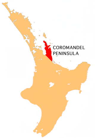
The Coromandel Peninsula on the North Island of New Zealand extends 85 kilometres (53 mi) north from the western end of the Bay of Plenty, forming a natural barrier protecting the Hauraki Gulf and the Firth of Thames in the west from the Pacific Ocean to the east. It is 40 kilometres (25 mi) wide at its broadest point. Almost its entire population lives on the narrow coastal strips fronting the Hauraki Gulf and the Bay of Plenty. In clear weather the peninsula is clearly visible from Auckland, the country's biggest city, which lies on the far shore of the Hauraki Gulf, 55 kilometres (34 mi) to the west. The peninsula is part of the Thames-Coromandel District and the Waikato Region.
Parengarenga Harbour is a natural harbour close to the northernmost point on the North Island of New Zealand. Located at the northern end of the Aupōuri Peninsula, it extends inland for over 10 kilometres, almost severing the northern tip of the island from the rest of the peninsula. The harbour's mouth is towards the northern end of Great Exhibition Bay. The island's northernmost point, at the North Cape is only about 10 kilometres north of the harbour. Te Hāpua is a settlement at the western side of the harbour.

Santa Elena is a town in southwestern Ecuador, and is the capital of both the province and the canton of the same name. Santa Elena, originally called Sumpa, is located on the Ecuadorian peninsula near the city of Guayaquil. It is regarded as the location of the most important and best documented archaeological site in the country, predominantly due to the discovery of the Lovers of Sumpa.

Salinas is a coastal city located in the Province of Santa Elena, Ecuador. It is the seat of the canton that bears its name. The westernmost city on mainland Ecuador, Salinas is an important tourist center. Salinas, Ecuador's largest coastal resort, offers one of the country's best real estate investment markets and most popular and most upscale beach lifestyle. It was the site of the ISA World Junior Surfing Games Ecuador in 2009. There are two major yacht clubs in Salinas, the first is Salinas Yacht Club, which is smaller than the Puerto Lucia Yacht Club, in Santa Elena, in an area known as 'La Libertad' which, in Spanish means 'The Freedom Town'. Puerto Lucia boasts a hotel, several restaurants, a private beach and apartment buildings, as well as the large marina and port.

Montañita is a small coastal town in Ecuador located in the parish of Manglaralto, province of Santa Elena, about 180 kilometers northwest of Guayaquil. Its name means "small mountain." In the mid 20th century it was known as a surfing beach, with only a few fishermen's huts, and one or two surfers tents in summer, erected at the site. But in 1960, Montañita, foreigners linked to the hippie movement decided to settle there permanently. It is now a popular destination for surfers from around the world and considered one of the best surfing beaches in Ecuador's south coast.
The Gulf of Penas is a body of water located south of the Taitao Peninsula, Chile.

"Las Vegas culture" is the name given to many Archaic settlements which flourished between 8000 BCE and 4600 BCE near the coast of present-day Ecuador. The name comes from the location of the most prominent settlement, Site No. 80, near the Las Vegas River and now within the city of Santa Elena. The Las Vegas culture represents "an early, sedentary adjustment to an ecologically complex coastal environment."

The Province of Santa Elena is a province of Ecuador in the coastal region. Created in 2007 from territory that belonged to the Guayas Province, it is one of the two newest provinces of Ecuador, along with Santo Domingo de Los Tsáchilas. Its capital city is Santa Elena, from which the province derives its name.

Punta Carneros is a beach located in the Salinas County, in the Santa Elena Province of Ecuador.
Cintra Bay or the Gulf of Cintra is a large, half-moon shaped bay on the coast of Río de Oro province, Western Sahara. It is located about 120 km (75 mi) south of Dakhla. Its coastline is sparsely populated, and the environment is mostly wild and undeveloped. Originally called "St. Cyprian's Bay", it was renamed after Captain Gonçalo de Sintra, a 15th-century Portuguese explorer who was thought to have met his death in the bay during an unauthorized, unsuccessful slave raid.
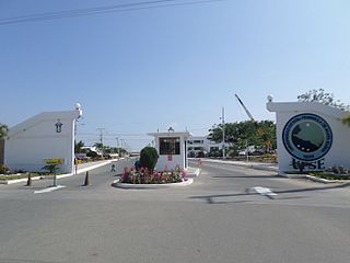
The State University Santa Elena Peninsula is a public university located in the canton freedom of the province of Santa Elena in the Republic of Ecuador, is the first autonomous center of teaching and which has the largest student population in the area.
References
| International | |
|---|---|
| National | |
2°11′45″S80°59′02″W / 2.1958°S 80.9838°W
| | This Ecuador location article is a stub. You can help Wikipedia by expanding it. |