Santa Rosa Valley

Last updated

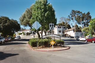
Coordinates: 34°14′38″N118°53′48″W / 34.2438889°N 118.8966667°W / 34.2438889; -118.8966667 The Santa Rosa Valley is a small valley and rural unincorporated community in Ventura County, Southern California. [1]

Geographic coordinate system Coordinate system

A geographic coordinate system is a coordinate system that enables every location on Earth to be specified by a set of numbers, letters or symbols. The coordinates are often chosen such that one of the numbers represents a vertical position and two or three of the numbers represent a horizontal position; alternatively, a geographic position may be expressed in a combined three-dimensional Cartesian vector. A common choice of coordinates is latitude, longitude and elevation. To specify a location on a plane requires a map projection.

Valley Low area between hills, often with a river running through it.

A valley is a low area between hills or mountains typically with a river running through it. In geology, a valley or dale is a depression that is longer than it is wide. The terms U-shaped and V-shaped are descriptive terms of geography to characterize the form of valleys. Most valleys belong to one of these two main types or a mixture of them, at least with respect to the cross section of the slopes or hillsides.

Unincorporated area Region of land not governed by own local government

In law, an unincorporated area is a region of land that is not governed by a local municipal corporation; similarly an unincorporated community is a settlement that is not governed by its own local municipal corporation, but rather is administered as part of larger administrative divisions, such as a township, parish, borough, county, city, canton, state, province or country. Occasionally, municipalities dissolve or disincorporate, which may happen if they become fiscally insolvent, and services become the responsibility of a higher administration. Widespread unincorporated communities and areas are a distinguishing feature of the United States and Canada. In most other countries of the world, there are either no unincorporated areas at all, or these are very rare; typically remote, outlying, sparsely populated or uninhabited areas.

The valley is about 5 miles (8.0 km) long (east to west) and 2 miles (3.2 km) wide (north to south).

Although not within its city limits, the community is sometimes considered to be an outlying neighborhood of Camarillo.

Camarillo, California City in California, United States

Camarillo is a city in Ventura County in the U.S. state of California. The population was 65,201 at the 2010 census, up from 57,084 at the 2000 census. The Ventura Freeway is the city's primary thoroughfare. Camarillo is named for Adolfo and Juan Camarillo, two of the few Californios to preserve the city's heritage after the arrival of Anglo settlers. The railroad coast route came through in 1898 and built a station here. Adolfo Camarillo eventually employed 700 workers growing mainly lima beans. Walnuts and citrus were also grown on the ranch. Adolfo bred Camarillo White Horses in the 1920s through the 1960s and was well known for riding them, dressed in colorful Spanish attire, in parades such as the Fiesta of Santa Barbara.

There is an elementary school within the valley, Santa Rosa Technology Magnet School, which is part of the PVSD district.

It is bordered on the south by the western Simi Hills and Wildwood Regional Park, and on the north by Las Posas Hills. The valley is drained principally by the Arroyo Santa Rosa, a tributary of Calleguas Creek which flows into the Pacific Ocean at Mugu Lagoon.

Simi Hills mountain range in Southern California, United States

The Simi Hills are a low rocky mountain range of the Transverse Ranges in eastern Ventura County and western Los Angeles County, of southern California, United States.

Wildwood Regional Park

Wildwood Regional Park is a suburban regional park in the western Simi Hills and Conejo Valley, in Ventura County, California. It is located in western Thousand Oaks, northern Newbury Park, and southern Moorpark.

Calleguas Creek is the terminus of a river system in Ventura County, California. It drains the Calleguas Creek Watershed, an area 30 miles long and 14 miles wide, which includes Simi Valley, Moorpark, Camarillo and a large portion of Thousand Oaks. Tributaries include Arroyo Simi, Arroyo Santa Rosa, Revolon Slough and Arroyo Conejo. It discharges into the Pacific Ocean, the Santa Barbara Channel, at Mugu Lagoon on Naval Base Ventura County, just north of Point Mugu, where the Santa Monica Mountains meet the ocean, marking the southern/eastern boundary of the Oxnard Plain.

Related Research Articles

Santa Rosa County, Florida county in Florida, United States of America

Santa Rosa County is a county located in the northwestern portion of the U.S. state of Florida. As of 2017 estimates, the population was 174,272. The county seat is Milton, which lies in the geographic center of the county. The largest communities are Navarre, Pace, and Gulf Breeze.

Rosamond, California census-designated place in California, United States

Rosamond is a census-designated place (CDP) in Kern County, California, USA, near the Los Angeles county line. 20 miles (32 km) north of Palmdale, in the Antelope Valley, the westernmost desert valley of the Mojave Desert. Rosamond is also 13 miles (21 km) south of Mojave, and 11 miles (18 km) north of Lancaster at an elevation of 2,342 feet (714 m). According to 2010 United States census data, the town population was 18,150.

Acton, California Census designated place in California, United States

Acton is an unincorporated census-designated place in Los Angeles County, California, near the Antelope Valley. According to the 2010 census, Acton had a population of 7,596.

Santa Rosa, New Mexico City in New Mexico, United States

Santa Rosa is a city in and the county seat of Guadalupe County, New Mexico, United States. The population was 2,848 at the 2010 census. It lies between Albuquerque and Tucumcari, situated on the Pecos River at the intersection of Interstate 40, U.S. Route 54, and U.S. Route 84. The city is located west of, but not within, the Llano Estacado or "staked plains" of eastern New Mexico and west Texas.

Santa Clarita Valley Place in California, United States

The Santa Clarita Valley is part of the upper watershed of the Santa Clara River in Southern California. The valley was part of the 48,612-acre (19,673 ha) Rancho San Francisco Mexican land grant. Located in Los Angeles County, its main population center is the city of Santa Clarita which includes the communities of Canyon Country, Newhall, Saugus, and Valencia. Adjacent unincorporated communities include Castaic, Stevenson Ranch, Val Verde, and the new master planned community of Newhall Ranch.

Santa Rosa Mountains (California)

The Santa Rosa Mountains are a short mountain range in the Peninsular Ranges system, located east of the Los Angeles Basin and northeast of the San Diego metropolitan area of southern California, in the southwestern United States.

North Hills, Los Angeles Neighborhood of Los Angeles in California, United States

North Hills is a community in the north-central San Fernando Valley, and within the City of Los Angeles, California.

Neenach, California Unincorporated community in California

Neenach is an agricultural settlement in northwestern Los Angeles County, California, with a population of about 800. It is facing a massive change with the proposed construction of a 23,000-home planned community to its north called Centennial.

University Hills, Los Angeles Neighborhood of Los Angeles in California, United States

University Hills is a district on the East Side of Los Angeles, California. It is the site of California State University, Los Angeles.

Soledad Canyon

Soledad Canyon is a long narrow canyon/valley located in Los Angeles County, California between the cities of Palmdale and Santa Clarita. It is a part of the Santa Clara River Valley, and extends from the top of Soledad Pass to the open plain of the Valley in Valencia. The upstream section of the Santa Clara River runs through it.

Coast Line (UP) railroad line in California along the Pacific coast

The Coast Line is a railroad line between Burbank, California and the San Francisco Bay Area, roughly along the Pacific Coast. It is the shortest rail route from Los Angeles to the Bay Area.

The Imperial Highway is a west-east thoroughfare in the counties of Los Angeles, Orange, San Diego, and Imperial in California. The main portion of the existing route begins at Vista Del Mar in Los Angeles near the Los Angeles International Airport and ends at the Anaheim - Orange line at Via Escola where it becomes Cannon Street. Formerly, the Route used to extend from Vista Del Mar to Calexico, where a portion of the highway still exists, but the Route was replaced with other highways, rendering the older portions of the Imperial Highway to fall out of use.

Santa Anita Canyon is a canyon in the San Gabriel Mountains, within the Angeles National Forest in Los Angeles County, California.

Santa Susana Pass State Historic Park

Santa Susana Pass State Historic Park is a California State Park of approximately 680 acres (2.8 km2) located on the boundary between Ventura and Los Angeles counties, between the communities of Chatsworth and Simi Valley. Geologically, the park is located where the Simi Hills meet the Santa Susana Mountains. Here in the western part of the Transverse Ranges, the land is dominated by high, narrow ridges and deep canyons covered with an abundant variety of plant life. The park offers panoramic views of the rugged natural landscape as a striking contrast to the developed communities nearby. The park is also rich in archaeological, historical and cultural significance.

Marvin Braude Mulholland Gateway Park

Marvin Braude Mulholland Gateway Park is a 1,500-acre (6.1 km2) park in the Santa Monica Mountains, with its trailhead at the southern terminus of Reseda Boulevard in Tarzana, Los Angeles, California. The park was named for former Los Angeles City Councilman Marvin Braude, who for more than 30 years led the effort to preserve the Santa Monica Mountains. It is part of the Santa Monica Mountains National Recreation Area.

Our Lady of the Valley primary school

Our Lady of the Valley is a large Catholic church and school located in the Canoga Park section of Los Angeles, California. It is the oldest parish in the western San Fernando Valley, having been established in 1921. When the parish was established, the western Valley was sparsely populated, and most of the 620 parishioners were involved in agriculture with livestock or walnut and orange groves. At the time of its formation, the parish’s boundaries covered 400 square miles (1,000 km2) from the Pacific Ocean to the south, the Ventura County line to the west, White Oak Avenue to the east, and the Santa Susana Mountains to the north. In the years after World War II, the San Fernando Valley shifted from agriculture to residential communities, and the Catholic population also swelled. The 400 square miles (1,000 km2) served by Our Lady of the Valley were carved up among nine sister parishes. Though its territory has been reduced to four square miles, the parish has grown from 620 parishioners to over 4100 families.

Simi Valley

Simi Valley is a synclinal valley in Southern California in the United States. It is an enclosed or hidden valley surrounded by mountains and hills. It is connected to the San Fernando Valley to the east by the Santa Susana Pass and the 118 freeway, and in the west the narrows of the Arroyo Simi and the Reagan Freeway connect to Moorpark and Ventura, California. The relatively flat bottom of the valley contains soils formed from shales, sandstones, and conglomerates eroded from the surrounding hills of the Santa Susana Mountains to the north, which separate Simi Valley from the Santa Clara River Valley, and the Simi Hills.

Bell Creek (Southern California) river in the United States of America

Bell Creek is a 10-mile-long (16 km) tributary of the Los Angeles River, in the Simi Hills of Ventura County and the San Fernando Valley of Los Angeles County and City, in Southern California.

Arroyo Calabasas is a 7.0-mile-long (11.3 km) tributary of the Los Angeles River, in the southwestern San Fernando Valley area of Los Angeles County in California.

Santa Rosa Valley, California census-designated place in California, United States

Santa Rosa Valley is a rural unincorporated community, named after the eponymous valley in which it lies, located in Ventura County, California, United States. For statistical purposes, the United States Census Bureau has defined Santa Rosa Valley as a census-designated place (CDP). The census definition of the area may not precisely correspond to local understanding of the area with the same name. The 2010 United States census reported Santa Rosa Valley's population was 3,334. Santa Rosa Valley sits at an elevation of 433 feet (132 m).

References