In the 2011 census, Nepal's population was approximately 26 million people with a population growth rate of 1.35% and a median age of 21.6 years. In 2016, the female median age was approximately 25 years old and the male median age was approximately 22 years old. Only 4.4% of the population is estimated to be more than 65 years old, comprising 681,252 females and 597,628 males. 61% of the population is between 15 and 64 years old, and 34.6% is younger than 14 years. In 2011, the Birth rate is estimated to be 22.17 births per 1,000 people with an infant mortality rate of 46 deaths per 1,000 live births. Compared to the infant mortality rate in 2006 of 48 deaths per 1000 live births, the 2011 IMR is a slight decrease within that 5-year period. Infant mortality rate in Nepal is higher in rural regions at 44 deaths per 1000 live births, whereas in urban regions the IMR is lower at 40 deaths per 1000 live births. This difference is due to a lack of delivery assistance services in rural communities compared to their urban counterparts who have better access to hospitals and neonatal clinics. Life expectancy at birth is estimated to be 67.44 years for females and 64.94 years for males. The mortality rate is estimated to be 681 deaths per 100,000 people. Net migration rate is estimated to be 61 migrants per 100,000 people. According to the 2011 census, 65.9% of the total population is literate.

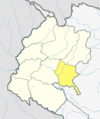
Lamjung District, a part of Gandaki Pradesh, is one of the 77 districts of Nepal. The district, with Besisahar as its district headquarters, covers an area of 1,692 square kilometres (653 sq mi) and as of 2011 had a population of 167,724. Lamjung lies in the mid-hills of Nepal spanning tropical to trans-Himalayan geo-ecological belts, including the geographical midpoint of the country. It has mixed habitation of casts and ethnicities. It is host to probably the highest density of the Gurung ethnic population in the country.

Sitarganj is a city and a municipal board in Udham Singh Nagar district in the Indian state of Uttarakhand. Now it is home to the Integrated Industrial Estate Sitarganj (IIE) being developed by State Industrial Development Corporation of Uttarakhand(SIDCUL).

A Village Development Committee (VDC) in Nepal was the lower administrative part of its Ministry of Federal Affairs and Local Development. Each district had several VDCs, similar to municipalities but with greater public-government interaction and administration. There were 3,157 village development committees in Nepal. Each VDC was further divided into several wards depending on the population of the district, the average being nine wards.limikot is the most popular place .there was a big pond this was made by (shankar) that like take a name of shankarpokhari.
Nepalese in the United Kingdom are British citizens or full-time residents of the United Kingdom whose ethnic origins lie fully or partially in Nepal. According to ONS estimates in 2019 there were 76,000 Nepalese-born people in the country.
The 1991 Nepal census was a widespread national census conducted by the Nepal Central Bureau of Statistics.

Khanchikot is a market center in Sandhikharka Municipality of Arghakhanchi District. The district lies in the Lumbini Zone of Western Nepal. The former village development committee (VDC) was converted into municipality on 18 May 2014 by merging the existing Sandhikharka, Bangla, Narapani, Khanchikot, Keemadada, Argha and Dibharna VDCs. During 1991 Nepal census it was estimated to have a total population of 4,628 individuals and had 930 houses.
Chaukati is a village in Sindhupalchok District in the Bagmati Zone of central Nepal. At the time of the 1991 Nepal census it had a population of 2346 and had 539 houses in the village. By 2011 the population had become 2497 in 627 households.
Maneshwara is a village in Sindhupalchok District in the Bagmati Zone of central Nepal. At the time of the 1991 Nepal census it had a population of 3065 and had 642 houses in the village. By 2011 the population had become 3393 in 789 households.
Pagretar is a village development committee in Sindhupalchowk District in the Bagmati Zone of central Nepal. Kothe is a populated location within the committee area. At the time of the 2001 Nepal census Pagretar had a population of 3352, and in 1991 there were 633 houses. By 2011 the population had become 2952 in 762 households.
Jorpati is a village and former Village Development Committee that is now part of Gokarneshwar Municipality in Kathmandu District in Province No. 3 of central Nepal. At the 2011 census it had a population of 84,567 making it one of the largest villages in the world. At the time of the 1991 Nepal census it had a population of 10,796 and had 1988 households in it.
Satungal is a village and former Village Development Committee that is now part of Chandragiri Municipality in Kathmandu District in Province No. 3 of central Nepal. Satungal is also known as Satyapur. At the time of the 1991 Nepal census it had a population of 2730 and had 464 households in it. At the time of the 2001 Nepal census Satungal had a population of 5834 and had 1375 households in it. Satungal had 5173 literate people i.e. 88.66%.
Borlang is a village development committee in northern-central Nepal. As of the 1991 Nepal census it had a population of 4,737 and had 837 houses.

Chulachuli is a rural municipality (gaunpalika) out of six rural municipality located in Ilam District of Province No. 1 of Nepal. There are a total of 10 municipalities in Ilam in which 4 are urban and 6 are rural.
Bhakunde is a village development committee in Baglung District in the Dhawalagiri Zone of central Nepal. At the time of the 1991 Nepal census it had a population of 3,833 and had 697 houses in the village. At the time of the 2011 Nepal census it had a population of 4,952 among which 2,443 were female and 2,509 were male. There were about 831 houses in the village.

Phidim Municipality is the headquarters of the Panchthar District in the Mechi Zone of eastern Nepal. Phidim was upgraded to a 'municipality' from a 'village', when a development committee merged with other VDCs - including the Phidim, Chokmagu and Siwa villages - on May 18, 2014. It offers a route for trekkers and locals, who travel to and from the Taplejung district bordering with the Tibetan Autonomous Region of China. It is also a commercial hub for the rural surroundings.
Pathari Shanishchare (पथरी-शनिश्चरे) is a Municipality in Morang District in the Koshi Zone of south-eastern Nepal. It was formed by merging three existing village development committees i.e. Hasandaha, Pathari and Sanischare in May 2014.
Nepal conducted a widespread national census in 2011 by the Nepal Central Bureau of Statistics. Working with the 58 municipalities and the 3915 Village Development Committees at a district level, they recorded data from all the municipalities and villages of each district. The data included statistics on population size, households, sex and age distribution, place of birth, residence characteristics, literacy, marital status, religion, language spoken, caste/ethnic group, economically active population, education, number of children, employment status, and occupation.
The 2001 Nepal census was conducted by the Nepal Central Bureau of Statistics. According to the census, the population of Nepal in 2001 was 23,151,423. Working with Nepal's Village Development Committees at a district level, they recorded data from all the main towns and villages of each district of Nepal. The data included statistics on population size, households, sex and age distribution, place of birth, residence characteristics, literacy, marital status, religion, language spoken, caste/ethnic group, economically active population, education, number of children, employment status, and occupation.

Sundar Haraicha is a municipality in Morang District of Province No. 1 in Nepal that was established on 10 March 2017 by merging the former municipalities Sundar Dulari and Koshi Haraicha. At the time of the 2011 Nepal census, the localities formed had a joint population of 80,518 people living in 18,610 individual households.