Related Research Articles

The Sheltowee Trace Trail is a 343-mile (552.00 km) National Recreation Trail that was created in 1979 and stretches from the Burnt Mill Bridge Trail Head in the Big South Fork National River and Recreation Area in Tennessee to northern Rowan County, Kentucky. The trail is named after Daniel Boone, who was given the name Sheltowee when he was adopted as the son of the great warrior Chief Blackfish of the Shawnee tribe.
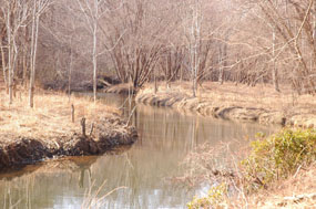
Lunice Creek is a 7.3-mile-long (11.7 km) tributary of the South Branch Potomac River, belonging to the Potomac River and Chesapeake Bay watersheds. The creek is located in Grant County, West Virginia. Lunice Creek is created by its North and South Forks and empties into the South Branch at Petersburg.

Pimmit Run is a 7.8-mile-long (12.6 km) stream in northern Virginia that runs from Fairfax County to the Potomac River at Chain Bridge in the Arlingwood neighborhood of Arlington.
Green Spring Run is an 8.9-mile-long (14.3 km) tributary stream of the North Branch Potomac River in Hampshire County in the U.S. state of West Virginia. Green Spring Run rises in Greenwood Hollow north of Springfield and meanders northeast through Green Spring Valley. The South Branch Valley Railroad and Green Spring Road run parallel to the stream. It runs through the community of Green Spring, from which the stream takes its name. From Green Spring, Green Spring Run flows east where it reaches its confluence with the North Branch Potomac shortly before the North Branch joins with the South Branch Potomac River to form the Potomac River.
Tygarts Creek is a tributary of the Ohio River in Carter and Greenup counties of northeastern Kentucky in the United States. It is 88 miles (142 km) long and drains an area of 339.6 square miles (880 km2). Via the Ohio, it is part of the watershed of the Mississippi River. Tygarts Creek is named for early Kentucky explorer Michael Tygart, who eventually drowned in the creek, somewhere near the mouth.

Spout Run is a small stream in Arlington County, Virginia. From its source along Interstate 66, Spout Run flows on a northeastern course paralleling the Spout Run Parkway through a gorge and empties into the Potomac River opposite the Three Sisters. With the exception of the adjacent parkway, Spout Run is surrounded predominantly by forests.
Kettle Creek is a 7.3-mile-long (11.7 km) tributary stream of the South Fork South Branch Potomac River in Hardy and Pendleton counties in West Virginia's Eastern Panhandle. Kettle Creek rises on Mitchell Knob and flows north along the eastern flanks of Sweedlin Hill through Sweedlin Valley in the George Washington National Forest.
Chopawamsic Creek is a 6.8-mile-long (10.9 km) tributary of the Potomac River in Prince William and Stafford counties, Virginia. Chopawamsic Creek is formed by the confluence of the North and South Branches of Chopawamsic Creek and empties into the Potomac River south of Quantico at the Marine Corps Base Quantico's Air Station. Breckenridge Reservoir lies at the stream's confluence with the North and South Branches. Along with its North Branch, Chopawamsic Creek forms part of the boundary between Prince William and Stafford counties. The North Branch flows through part of the Chopawamsic Backcountry Area in Prince William Forest Park.
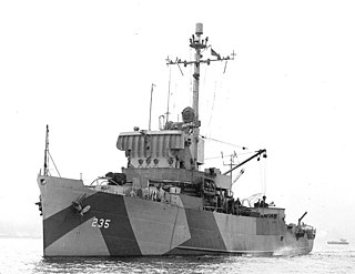
USS Fixity (AM-235) was an Admirable-class minesweeper built for the United States Navy during World War II. The ship was ordered and laid down as PCE-905-class patrol craft USS PCE-908 but was renamed and reclassified before her December 1944 commissioning as Fixity (AM-235). She earned two battle stars in service in the Pacific during the war. She was decommissioned in November 1946 and placed in reserve. In January 1948, she was transferred to the United States Maritime Commission which sold her into merchant service in 1949. Operating as the Commercial Dixie, she sank in the Ohio River in the late 1990s.
The Red Bird River is one of two tributaries at the head of the South Fork Kentucky River, the other being the Goose Creek. It is located in the Daniel Boone National Forest, in the southeast of the U.S. state of Kentucky. It is 34.3 miles (55.2 km) long and drains the eastern half of Clay County.
Foundry Branch is a tributary stream of the Potomac River in Washington, D.C.
Horse Creek is a creek a tributary of Goose Creek river in Clay County, Kentucky. It is 1.5 miles (2.4 km) upstream of Manchester on Goose at an altitude of 800 feet (240 m).
Trace Fork or Trace Branch is a creek in Perry County, Kentucky in the United States. It a fork of Lotts Creek 1 mile (1.6 km) upstream from the latter's mouth at an altitude of 825 feet (251 m).
Stinking Creek is a stream in Knox County, Kentucky, in the United States.
Cassidy Creek is a stream in Fleming County, Kentucky, in the United States. It is a tributary of the Licking River.
Salt Lick Creek is a stream in Lewis County, Kentucky, in the United States. It is a tributary of the Ohio River.
Lawrence Creek is a stream in Mason County, Kentucky, in the United States. It is a tributary of the Ohio River.
Thousandsticks Branch is a stream in Leslie County, Kentucky, in the United States.
Rowdy Branch is a stream located entirely within Perry County, Kentucky.
Norton Branch is a stream in Carter County of the U.S. state of Kentucky. It is a tributary of Williams Creek.
References
- ↑ U.S. Geological Survey Geographic Names Information System: Sap Branch
- ↑ Collins, Lewis (1877). History of Kentucky. p. 233.
38°20′52″N83°51′26″W / 38.3478545°N 83.8571444°W
| | This Fleming County, Kentucky state location article is a stub. You can help Wikipedia by expanding it. |