
Interstate 70 (I-70) is a major east–west Interstate Highway in the United States that runs from I-15 near Cove Fort, Utah, to I-695 near Baltimore, Maryland. I-70 approximately traces the path of U.S. Route 40 east of the Rocky Mountains. West of the Rockies, the route of I-70 was derived from multiple sources. The Interstate runs through or near many major cities, including Denver, Kansas City, St. Louis, Indianapolis, Columbus, Pittsburgh, and Baltimore.

Shawnee County is a county in northeast Kansas, in the central United States of America. As of the 2010 census, the population was 177,934 making it the third-most populous county in Kansas. Its most populous city, Topeka, is the state capital and county seat. The county was one of the original 33 counties created by the first territorial legislature in 1855, and it was named for the Shawnee tribe of Native Americans.
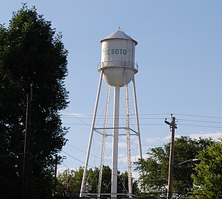
De Soto is a city in Johnson and Leavenworth counties in the U.S. state of Kansas, and part of the Kansas City Metropolitan Area. The vast majority of the city, 11.13 square miles (28.8 km2), lies within Johnson County. As of the 2010 census, the city population was 5,720.
The Kansas Turnpike is a 236-mile-long (380 km), freeway-standard toll road that lies entirely within the U.S. state of Kansas. It runs in a general southwest–northeast direction from the Oklahoma border to Kansas City. It passes through several major Kansas cities, including Wichita, Topeka, and Lawrence. The turnpike is owned and maintained by the Kansas Turnpike Authority (KTA), which is headquartered in Wichita.

The Kansas City metropolitan area is a 15 county metropolitan area anchored by Kansas City, Missouri, and straddling the border between the U.S. states of Missouri and Kansas. With a population of 2,104,509, it ranks as the second largest metropolitan area centered in Missouri. Alongside Kansas City, the area includes a number of other cities and suburbs, the largest being Overland Park, Kansas; Kansas City, Kansas; Olathe, Kansas; and Independence, Missouri; each over 100,000 in population. The Mid-America Regional Council (MARC) serves as the Council of Governments and the Metropolitan Planning Organization for the area.

Turner is a neighborhood within Kansas City, Kansas, United States. It was formerly an unincorporated community of Wyandotte County, similar to Piper, Kansas. Turner has its own school district, Turner USD #202.
Tecumseh is an unincorporated community in Shawnee County, Kansas, United States. It is situated along the Kansas River. The community and township are both named for the famous Shawnee chief.
Interstate 470 (I-470) is a 13.72-mile (22.08 km) loop highway that bypasses the downtown area of Topeka, Kansas. I-470 begins at an interchange with I-70 in western Topeka and heads generally southeast, running concurrent with U.S. Route 75 (US-75). The concurrency with US-75 ends 5.74 miles (9.24 km) later at the Burlingame Road interchange. I-470 becomes part of the Kansas Turnpike at its junction with I-335. From there, the highway heads generally northeast through the southeastern sections of Topeka. After traveling 7.03 miles (11.31 km) as the Kansas Turnpike, I-470 reaches its eastern terminus at I-70. The highway has annual average daily traffic values as high as 43,000 west of Gage Boulevard to as low as 10,370 near the eastern terminus. As an Interstate Highway, I-470 is a part of the United States National Highway System. The non-turnpike portions of the highway are maintained by the Kansas Department of Transportation, while the turnpike portion is maintained by the Kansas Turnpike Authority.

Topeka Regional Airport, formerly known as Forbes Field, is a public airport owned by the Metropolitan Topeka Airport Authority in Shawnee County, Kansas, seven miles south of downtown Topeka, the capital city of Kansas. The National Plan of Integrated Airport Systems for 2011–2015 called it a general aviation airport. United Express scheduled airline flights on January 7, 2014, two daily regional jets to Chicago's O'Hare International Airport, but ceased on September 2, 2014. Allegiant Air scheduled jets nonstop to Las Vegas, but discontinued service on July 30, 2007.

The Topeka & Shawnee County Public Library is a public library located in Topeka, Kansas, United States. It serves all of Shawnee County, Kansas with the exception of the Rossville, Kansas and Silver Lake, Kansas townships. The Topeka & Shawnee County Public Library is a municipal taxing district authorized by Kansas law. It is governed by a board of trustees consisting of ten members.
K-4 is the longest designated state highway in Kansas traversing from north of Scott City at US-83 to US-59 near Nortonville in northeast Kansas. A segment of the highway in Saline County overlaps Interstate 135, and a section in Topeka runs concurrent with Interstate 70.
The North Kansas Avenue Bridge is a four lane, automobile and pedestrian crossing of the Kansas River at Topeka, Kansas, U.S.A. The bridge connects downtown Topeka to North Topeka. It is open to traffic.
Armourdale community is a district in the lower part of the Kansas River valley in Kansas City, Kansas. It is a main district between the West Bottoms and the Rosedale, Kansas area. The Kansas River makes an oxbow curve around the entire district, which is home to Shawnee Park and Bill Clem Park.
Montara is an unincorporated community in Shawnee County, Kansas, United States. It is located south of Topeka.
Fort Simple was an American fort built in Topeka, Kansas, as a result of Maj. Gen. Sterling Price's Missouri Raid in the late summer and fall of 1864. Topeka had become the permanent capital of the State of Kansas in 1861, but no fortifications had been built to protect the city from guerrilla bands, which roamed eastern Kansas. Even the raid and massacre in August 1863 in Lawrence, Kansas, did not result in a fort being built to protect the capital, although plans had been made to build one by July 1864.

The Highway 2 Bridge is an automobile and pedestrian crossing of the Kansas River on the border of Johnson and Leavenworth Counties in De Soto. The current bridge was built in 1964.
Stormont Vail Health is an extensive medical facility in the city of Topeka, Kansas. The facility provides a nonprofit hospital and integrated health care system for Shawnee County and the northeast Kansas region.

The West Broadway Bridge, aka West Street Bridge and the Concrete-Metal Bridge, is a vehicular bridge over the Passaic River in Paterson, New Jersey. It carries West Broadway, traditionally the Paterson-Hamburg Turnpike, and connects to County Route 509 at its west end.


