
Uummannaq Fjord is a large fjord system in the northern part of western Greenland, the largest after Kangertittivaq fjord in eastern Greenland. It has a roughly south-east to west-north-west orientation, emptying into the Baffin Bay in the northwest.

Itilleq is a settlement in the Qeqqata municipality in central-western Greenland. It is located on a small island around 1 km from the mainland, 45 km south of Sisimiut and 2 km north of the Arctic Circle on the shores of Davis Strait. It had 89 inhabitants in 2020.
Sarfannguit is a settlement in the Qeqqata municipality in central-western Greenland. Its population was 96 in 2020. The settlement was founded in 1843. The town is located within the Aasivissuit – Nipisat UNESCO World Heritage Site, and is inscribed on the World Heritage List in 2018 for its outstanding archeological sites representing the human occupation of Greenland for over 4000 years.

Oqaatsut, formerly Rodebay or Rodebaai, is a settlement in Avannaata municipality, in western Greenland. It had 29 inhabitants in 2020. The modern name of the settlement is Kalaallisut for "Cormorants". The village is served by the communal all-purpose Pilersuisoq store.

Ammassalik Fjord is a 41 km (25.5 mi) long fjord in the Sermersooq municipality in southeastern Greenland.

Nuussuaq Peninsula is a large peninsula in western Greenland.

Torsukattak Strait is a strait in Avannaata municipality in northwestern Greenland.
Kangerlussuaq Fjord is a long fjord in the Qeqqata municipality in central-western Greenland. The fjord is 190 km (120 mi) long and between 1.5 km (0.93 mi) and 8 km (5.0 mi) wide, flowing from the estuary of Qinnguata Kuussua river to the southwest, and emptying into the Davis Strait. It is the longest fjord of western Greenland.
Tunulliarfik Fjord is a fjord near Qaqortoq in the Kujalleq municipality in southern Greenland. It is the inner section of Skovfjord (Skovfjorden). In times of the Norse settlement in southern Greenland, it was known as Eiriksfjord.
Torsuut Tunoq is a sound on the southeastern coast of Greenland. It is an inner waterway of the North Atlantic.

Simiutaq Island is a 13 km × 10 km uninhabited island in the Qeqqata municipality in western Greenland, located in the mouth of the long Kangerlussuaq Fjord. It was also known informally as Cruncher Island.
Kangerluarsunnguaq Bay is a bay of the Davis Strait in the Qeqqata municipality on the western coast of Greenland. It is located directly to the north of Sisimiut.
Amerloq Fjord is a 36 km (22 mi) long fjord in the Qeqqata municipality in western Greenland. The fjord empties into the Davis Strait just south of Sisimiut, whose former Inuit name was also "Amerloq".
Kangerluarsuk Tulleq is a 28 km (17 mi) long fjord in the Qeqqata municipality in western Greenland. The fjord is of roughly east–west orientation, emptying into Davis Strait in the west.
Kangerlussuatsiaq Fjord is a fjord in the Qeqqata municipality in western Greenland. Taking its source in the tidewater glaciers draining the Maniitsoq ice cap, the fjord flows in a deep canyon through a mountainous, uninhabited region, emptying into Davis Strait near the settlement of Kangaamiut.
Kangaamiut Kangerluarsuat Fjord is a fjord in the Qeqqata municipality in western Greenland. The fjord is located halfway between the lower runs of the long Kangerlussuaq Fjord in the north, and Kangerlussuatsiaq Fjord in the south, emptying into Davis Strait.
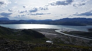
Tarajornitsut is an uninhabited tundra highland in the Qeqqata municipality in central-western Greenland, within the bounds of Kangaamiut dike swarm. The highland has many lakes, shallow valleys, hills, and wetlands, with plentiful wildlife, such as arctic geese. It is also a major calving ground for reindeer. In the future the area will become a protected nature reserve. The Polar Route from Sisimiut to Kangerlussuaq ends in Tarajornitsut, on the shore of Kangerlussuaq Fjord.
Isortoq Fjord is a fjord in the Qeqqata municipality in western Greenland. The fjord to the east of Maniitsoq, emptying into Davis Strait. Majorqaq, one of the widest rivers in western Greenland draining the Greenland ice sheet, empties into the fjord head.
Ikertooq Fjord is a 55 km (34 mi) long fjord in the Qeqqata municipality in western Greenland. The fjord empties into Davis Strait 21 km (13 mi) south of Sisimiut.
Nipisat Island is a small, uninhabited island in the Qeqqata municipality in central-western Greenland.

