Sarju Sagar Dam

Last updated

Sarju Sagar Dam
सरजू सागर बांध
Aerial View of Sarju Sagar Dam, UDW, August 2018.png
Rajasthan relief map.svg
Red pog.svg
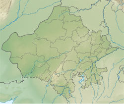
Location of Sarju Sagar Dam
सरजू सागर बांध in Rajasthan
India relief location map.jpg
Red pog.svg
Sarju Sagar Dam (India)
Official nameKot Dam or Kot Bandh
CountryIndia
LocationKot, Jhunjhunu
Coordinates 27°39′2″N75°25′10″E / 27.65056°N 75.41944°E / 27.65056; 75.41944
PurposeWater Storage, Irrigation
StatusOperational
Opening date1924;99 years ago (1924)
Dam and spillways
Type of dam Masonry with embankment main sections
Height7.6 m (25 ft)
Length80 m (260 ft)

Sarju Sagar Dam also known as Kot Dam is a dam across the Shakambhari Hills. It is situated 13 kilometres from Udaipurwati town in Jhunjhunu, Rajasthan, India. [1] The dam was constructed between 1923 and 1924 for the purposes of Irrigation and Water Storage. [2] [3]

Contents

A river flows from it that's name is "Saptrupi river" , this flows from Kot dam to udaipurwati

Nearest places

Related Research Articles

<span class="mw-page-title-main">Ravi River</span> River in India and Pakistan

The Ravi River is a transboundary river crossing northwestern India and eastern Pakistan. It is one of five rivers associated with the Punjab region.

<span class="mw-page-title-main">Mahi River</span> River in India

The Mahi is a river in western India. It rises in Madhya Pradesh and, after flowing through the Vagad region of Rajasthan, enters Gujarat and flows into the Arabian Sea. It is one of the relatively few west-flowing rivers in India, alongside the endorheic Luni River, the Sabarmati River, the Tapi River and the Narmada River. Most peninsular rivers in India flow eastward into the Bay of Bengal or northward into the Ganges River.

<span class="mw-page-title-main">Chambal River</span> River in India

The Chambal River is a tributary of the Yamuna River in Central and Northern India, and thus forms part of the drainage system of the Ganges. The river flows north-northeast through Madhya Pradesh, running for a time through Rajasthan, then forming the boundary between Rajasthan and Madhya Pradesh before turning southeast to join the Yamuna in Uttar Pradesh state.

<span class="mw-page-title-main">Bhakra Dam</span> Dam in Himachal Pradesh, India

Bhakra Nangal Dam is a concrete gravity dam on the Satluj River in Bhakra Village near Bilaspur in Bilaspur district, Himachal Pradesh in northern India. The dam forms the Gobind Sagar reservoir.

<span class="mw-page-title-main">Gandhi Sagar Dam</span> Dam in Mandsaur District Madhya Pradesh

GandhisagarDam is situated at a distance of 168 km from the District headquarter. The Dam is constructed on the Chambal River.

<span class="mw-page-title-main">Nagarjuna Sagar Dam</span> Dam in Andhra Pradesh & Nalgonda district, Telangana

Nagarjuna Sagar Dam is a masonry dam across the Krishna River at Nagarjuna Sagar which straddles the border between Palnadu district in Andhra Pradesh and Nalgonda district in Telangana. The dam provides irrigation water to the districts of Palnadu, Guntur, Nalgonda, Prakasam, Khammam, Krishna, and parts of West Godavari. It is also a source of electricity generation for the national grid.

Kota Barrage is the fourth in the series of Chambal Valley Projects, located about 0.8 km upstream of Kota City in Rajasthan. Water released after power generation at Gandhi Sagar dam, Rana Pratap Sagar dam and Jawahar Sagar Dams, is diverted by Kota Barrage for irrigation in Rajasthan and in Madhya Pradesh through canals on the left and the right sides of the river. The work on this dam started in 1954 and was completed in 1960.

<span class="mw-page-title-main">Jhunjhunu district</span> District of Rajasthan in India

Jhunjhunu district is a district of the Indian state of Rajasthan in northern India. The city of Jhunjhunu is the district headquarters.

<span class="mw-page-title-main">Indirasagar Dam</span> Dam in Madhya Pradesh, India

The Indira Sagar Dam is the largest dam in India, in terms of volume of water stored in the reservoir. It is located on the Narmada River at the town of Narmada Nagar, Punasa in the Khandwa district of Madhya Pradesh in India. The foundation stone of the project was laid by the prime minister of India Indira Gandhi on 23 October 1984. The construction of the main dam started in 1992. The downstream projects of ISP are Omkareshwar, Maheshwar, and Sardar Sarovar Project. To build it, a town of 22,000 people and 100 villages was displaced.

Sarayu, or Sarju, is a river in Uttarakhand, India.

Udaipurwati is a small town and a municipality in Neem Ka Thana in the Indian state of Rajasthan. Neem Ka Thana, Sikar, Sri Madhopur Khandela and Neem ka thana are some more developed towns near Udaipurwati. Udaipurwati (उदयपुरवाटी) is a town and tahsil in the Neem Ka Thana district in Rajasthan. Its ancient name, mentioned in Harsha Inscription 961 AD (L-39), was Udarbhatika (उदर्भटिका).

<span class="mw-page-title-main">Banasura Sagar Dam</span> Dam in Wayanad, Kerala

Banasura Sagar Dam, which impounds the Karamanathodu tributary of the Kabini River, is part of the Indian Banasurasagar Project consisting of a dam and a canal project started in 1979. The goal of the project is to support the Kakkayam Hydro electric power project and satisfy the demand for irrigation and drinking water in a region known to have water shortages in seasonal dry periods. The dam is also known as Kuttiyadi Augmentation Main Earthen Dam. The dam has a height of 38.5 metres (126 ft) and length of 685 metres (2,247 ft).

<span class="mw-page-title-main">Rana Pratap Sagar Dam</span> Dam in Chittorgarh District, Rajasthan

The Rana Pratap Sagar Dam is a gravity masonry dam of 53.8 metres (177 ft) height built on the Chambal River at Rawatbhata in Rajasthan in India. It is part of integrated scheme of a cascade development of the river involving four projects starting with the Gandhi Sagar Dam in the upstream reach in Madhya Pradesh and the Jawahar Sagar Dam on the downstream with a terminal structure of the Kota Barrage in Rajasthan for irrigation.

The Jawahar Sagar Dam is the third dam in the series of Chambal Valley Projects on the Chambal River, located 29 km upstream of Kota city and 26 km downstream of Rana Pratap Sagar dam. It is a concrete gravity dam, 45 meters high and 393 meters long, generating 60 MW of power with an installed capacity of 3 units of 33 MW. Its construction was completed in 1972. The dam's gross storage capacity is 67.07 million cubic meters. The total catchment area of the dam is 27,195 km2, of which only 1,496 km2 are in Rajasthan. The free catchment area below Rana Pratap Sagar dam is 2,331 km2. The dam is located after the Gandhi Sagar Dam and Rana Pratap Sagar Dam, but before the Kota Barrage.

<span class="mw-page-title-main">Fateh Sagar Lake</span> Lake in Udaipur, Rajasthan, India

Fateh Sagar Lake is situated in the city of Udaipur in the Indian state of Rajasthan. It is an artificial lake named after Maharana Fateh Singh of Udaipur and Mewar, constructed north-west of Udaipur, to the north of Lake Pichola in the 1680s.

<span class="mw-page-title-main">Basava Sagara</span> Dam in Karnataka, India

Basava Sagar Dam, previously known as Narayanpura Dam, is a dam constructed across the Krishna River at Yadgir District, Karnataka State, India. The reservoir that it impounds is known as Basava Sagar, and has a total storage capacity of 37.965 tmcft (1.075 km³), with 30.5 tmcft (0.85 km³) live storage. The full reservoir level is 492.25 m MSL and the minimum draw down level is 481.6 m MSL. It was a single purpose project meant only for irrigation, but downstream electrical generation and drinking water considerations enter into its management. The dam is 29 meters high and over 10.637 kilometres (6.610 mi) long, and has 30 gates for water release. 22 Spillway Gates are present in the Dam It took Rs. 50.48 crore to complete.

Udaipurwati Assembly constituency is one of constituencies of Rajasthan Legislative Assembly in the Jhunjhunu Lok Sabha constituency.

The Shahpurkandi Dam project is located on the Ravi River in Pathankot district, Punjab, India, downstream from the existing Ranjit Sagar Dam. The power houses will be constructed on Hydel Channel, which is downstream from Shahpurkandi Dam. The water released by Ranjit Sagar Dam is to be utilised for generating power for this project. The project will generate electricity of up to 206MW and provide irrigation to Punjab and Jammu and Kashmir. The construction of the dam is as per the framework of the Indus Water Treaty regarding sharing of rivers between India and Pakistan.

<span class="mw-page-title-main">Sarju</span> River in Uttarakhand, India

The Sarju, also known as Sarayu, is a major river draining Central Kumaon region in the Indian state of Uttarakhand. Originating from Sarmul, Sarju flows through the cities of Kapkot, Bageshwar and Seraghat before joining Mahakali at Pancheshwar. The Sarju is the largest tributary of the Sharda River. The river forms the South-eastern border between the districts of Pithoragarh and Almora. Temperate and sub-Tropical forests cover the entire Catchment area of the River.

The Kakund River is a small river in Bharatpur district and Karauli District, Rajasthan, India. It flows from the hills of Karauli district and enters the south-western border of Bayana Tehsil from the Karauli side. Its waters are held up in the Baretha reservoir, which is the largest storage of water in the region.

References

  1. "Kot Dam" . Retrieved 8 September 2018.
  2. "Sarju Sagar Dam - Jhunjhunu Edition" . Retrieved 8 September 2018.
  3. "कोट बांध में 4 फीट पानी और आया". Dainik Bhaskar (in Hindi). Retrieved 8 September 2018.