External links
Coordinates: 52°36′29″N4°08′13″W / 52.608°N 4.137°W
| | This Gwynedd location article is a stub. You can help Wikipedia by expanding it. |
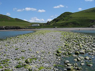
Sarn y Bwch, (Welsh for 'buck's causeway'), is one of three parallel reefs extending beneath the sea into Cardigan Bay from the west coast of Wales. The causeway, probably a medial moraine is made of glacial deposits left by receding ice sheets at the end of the last ice age. It is sometimes called Sarn y Bwlch ('the causeway of the pass'), but this form is later and less common than Sarn y Bwch.
Sarn y Bwch is the central of the three, extending south-westwards from near Tywyn. To the north is the causeway of Sarn Badrig, whilst to the south is Sarn Gynfelyn, which extends from near Aberystwyth.
Coordinates: 52°36′29″N4°08′13″W / 52.608°N 4.137°W
| | This Gwynedd location article is a stub. You can help Wikipedia by expanding it. |

Snowdonia is a mountainous region in northwestern Wales and a national park of 823 square miles (2,130 km2) in area. It was the first to be designated of the three national parks in Wales, in 1951.

Ceredigion is a county in the west of Wales, corresponding to the historic county of Cardiganshire. During the second half of the first millennium Ceredigion was a minor kingdom. It has been administered as a county since 1282. Ceredigion is considered a centre of Welsh culture and more than half the population can speak Welsh. The county is mainly rural with over 50 miles (80 km) of coastline and a mountainous hinterland. The numerous sandy beaches and the long-distance Ceredigion Coast Path provide excellent views of Cardigan Bay.
The A487, officially the Fishguard to Bangor Trunk Road, is a trunk road in Wales that follows the coast from Haverfordwest, Pembrokeshire, in the south, to Bangor, Gwynedd, in the north.

Cardigan Bay is a large inlet of the Irish Sea, indenting the west coast of Wales between Bardsey Island, Gwynedd in the north, and Strumble Head, Pembrokeshire at its southern end. It is the largest bay in Wales.

Sarn Helen refers to several stretches of Roman road in Wales. The 160-mile (260 km) route, which follows a meandering course through central Wales, connects Aberconwy in the north with Carmarthen in the west. Despite its length, academic debate continues as to the precise course of the Roman road. Many sections are now used by the modern road network while other parts are still traceable. However, there are sizeable stretches that have been lost and are unidentifiable.

Cantre'r Gwaelod, also known as Cantref Gwaelod or Cantref y Gwaelod, is a legendary ancient sunken kingdom said to have occupied a tract of fertile land lying between Ramsey Island and Bardsey Island in what is now Cardigan Bay to the west of Wales. It has been described as a "Welsh Atlantis" and has featured in folklore, literature, and song.

Sarn Badrig, also spelled Sarn Padrig, is one of several more or less parallel shingle reefs extending under the sea in Cardigan Bay on the west coast of Wales. The causeway is made of glacial deposits left by receding ice sheets at the end of the last ice age.
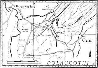
Luentinum or Loventium was a fort and mining settlement in the Roman province of Britannia. It was associated with the Dolaucothi Gold Mines, and its remains lie beneath the adjoining village of Pumsaint in the Welsh county of Carmarthenshire. It lay between similar forts at Llandovery and Bremia near Llanio, and some distance away from the fort at Llandeilo. The Roman road Sarn Helen linked Luentinum with Llanio and Llandovery.
Diamond was a three-masted square rigger, built in New York City in 1823. She was one of the first ships to operate a regular service for passenger and cargo between Britain and the United States. She sank en route to Liverpool from New York on 2 January 1825 in Cardigan Bay. The alleged wreck site was identified in 2000 and was designated under the Protection of Wrecks Act 1973 on 1 April 2002, the first such designation by the National Assembly for Wales. However, the identification has since been called into question.
The Ceredigion Coast Path is a waymarked long distance footpath in the United Kingdom, on the coast of Ceredigion, Wales. It is 65 miles (105 km) in length, running along the coast of Cardigan Bay from Cardigan (52.0810°N 4.6608°W) to Ynyslas (52.5271°N 4.0495°W).

The River Dysynni is a river in mid Wales. Its source is the Tal-y-llyn Lake just south of the Cadair Idris massif and its mouth is in the Cardigan Bay area of the Irish Sea to the north of Tywyn. It measures about 16 mi (26 km) in length.
The Afon Leri is a river in Ceredigion, Wales. It rises at Llyn Craig-y-Pistyll and is joined at Talybont by Afon Ceulan before passing behind Borth to its mouth in the Dyfi estuary at Ynyslas.
Sarn Gynfelyn is a shingle spit on the coast of Cardigan Bay, in the county of Ceredigion, Mid-Wales, in the United Kingdom. It is located at Wallog, a few kilometres north of Llangorwen, close to Clarach Bay, south of Borth and north of the town of Aberystwyth.

Caer Lêb is a Roman and mediaeval site on the Welsh island of Anglesey, west of Brynsiencyn. Its name means "Leaven Castle". It is a low-lying site near the Afon Braint with a double row of pentangular banks and marshy ditches. The original entrance was on the east, other gaps are modern and caused by animals. Based on the excavation of a similar site elsewhere on Anglesey, it may date from the 2nd century BCE.

Ceibwr Bay is a bay opening into the Irish Sea in Pembrokeshire, west Wales. It is about 7 km west of Cardigan, and 3 km south of the headland of Cemaes Head. It is owned by the National Trust, within the Pembrokeshire Coast National Park and on the Pembrokeshire Coast Path.

Dinas Island is a peninsula, partially detached from the mainland, in the community of Dinas Cross between Fishguard and Newport, Pembrokeshire, in southwest Wales. A triangulation point shows 466 feet (142 m) above sea level at Pen-y-fan. Although Dinas Head is the northernmost part of the promontory where the cliffs meet the sea, the name is sometimes loosely used to refer to this highest point. Dinas Island is contained within the Pembrokeshire Coast National Park and the headland is under the care of the National Trust.
The geology of Snowdonia National Park is dominated by sedimentary and volcanic rocks from the Cambrian and Ordovician periods with intrusions of Ordovician and Silurian age. There are Silurian and Cenozoic sedimentary rocks on the park's margins. The succession was intensely faulted and folded during the Caledonian Orogeny. The region was uplifted as the North Atlantic Ocean opened during the Cenozoic. The current mountainous landscape arises from repeated glaciations during the Quaternary period.
The bedrock geology of Ceredigion in west Wales consists wholly of a considerable thickness of Ordovician and Silurian age sedimentary rocks of marine origin. Unconsolidated deposits of Quaternary age include a widespread cover of glacial till, valley floor alluvium and scattered peat deposits in both upland and lowland settings.
Newport Bay is a bay on a section of the north Pembrokeshire coast, Wales, which is within the Pembrokeshire Coast National Park. The bay is one of many in the much larger Cardigan Bay, and it stretches from Dinas Island to the headland of Pen-y-bâl, two miles to the east. It is overlooked by the town of Newport and the River Nevern flows into the bay.

The coastline of Wales extends from the English border at Chepstow westwards to Pembrokeshire then north to Anglesey and back eastwards to the English border once again near Flint. Its character is determined by multiple factors, including the local geology and geological processes active during and subsequent to the last ice age, its relative exposure to or shelter from waves, tidal variation and the history of human settlement and development which varies considerably from one place to another. The majority of the coast east of Cardiff in the south, and of Llandudno in the north, is flat whilst that to the west is more typically backed by cliffs. The cliffs are a mix of sandstones, shales and limestones, the erosion of which provides material for beach deposits. Of the twenty-two principal areas which deliver local government in Wales, sixteen have a coastline, though that of Powys consists only of a short section of tidal river some distance from the open sea. Its length has been estimated at 1,680 miles (2,700 km).