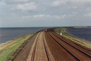
Sarn Badrig 4 km from landVisible at very low spring tide
Sarn Badrig, also spelled Sarn Padrig (Welsh for 'St. Patrick's causeway'), is one of several more or less parallel shingle reefs extending under the sea in Cardigan Bay on the west coast of Wales. The causeway is made of glacial deposits left by receding ice sheets at the end of the last ice age.
Sarn Badrig is the longest and most northerly of these, and extends south-westwards under the sea from Mochras Point, near Harlech, parallel to the Llŷn Peninsula for a length of about 20km, and can be seen at low tide. It is a hazard to shipping.
A neighbouring causeway is that of Sarn y Bwch, which is close to Tywyn.
Gwyddno Garanhir was the supposed ruler of a sunken land off the coast of Wales, known as Cantre'r Gwaelod. He was the father of Elffin ap Gwyddno, the foster-father of the famous Welsh poet Taliesin in the legendary account given in the late medieval Chwedl Taliesin.
Borth, is a village and seaside resort in Ceredigion, Mid Wales, 7 miles north of Aberystwyth on the Ceredigion Coast Path. The community includes the settlement of Ynyslas. The population was 1,399 in 2011. From being largely Welsh-speaking, the village has become anglicised: over 54 per cent of its residents were born in England. According to both the 1991 and 2001 censuses, 43 per cent of the residents of Borth were primarily Welsh-speakers.
A causeway is a track, road or railway on the upper point of an embankment across "a low, or wet place, or piece of water". It can be constructed of earth, masonry, wood, or concrete. One of the earliest known wooden causeways is the Sweet Track in the Somerset Levels, England, which dates from the Neolithic age. Timber causeways may also be described as both boardwalks and bridges.
Cemaes is a village on the north coast of Anglesey in Wales, sited on Cemaes Bay, an Area of Outstanding Natural Beauty which is partly owned by the National Trust. It is the most northerly village in Wales. The name Cemaes derives from the Welsh word cemais, meaning "bend or loop in a river, inlet of sea, bay". In 2011 the population of Cemaes in Llanbadrig community was 1,357. The most northerly point in Wales, Ynys Badrig, is nearby.
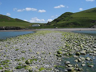
Mochras, is a peninsula lying west of Llanbedr in Gwynedd, Wales. It was formed after the River Artro was diverted by the Earl of Winchelsey in 1819 from its previous course where it entered the sea to the south of Mochras. Prior to this, access to the ancient settlement on the 'island' would have been through the village of Llandanwg, which is now across the estuary.
Cardigan Bay is a large inlet of the Irish Sea, indenting the west coast of Wales between Bardsey Island, Gwynedd in the north, and Strumble Head, Pembrokeshire at its southern end. It is the largest bay in Wales.
Middle Mouse is an uninhabited island situated 1 kilometre off the north coast of Anglesey. It is notable as the northernmost point of Wales. The island measures a maximum of 207 metres by 110 metres, with a maximum area of 3.7 acres and has a maximum altitude of 16 metres (52') above sea level. It is one of a chain of three islands off the north of Anglesey, the others being Ynys Amlwch and Maen y Bugail.
Bedd Taliesin is the legendary grave (bedd) of the poet Taliesin, located in Ceredigion, Wales. The Bronze Age round cairn is a listed Historic Monument. It is a round-kerb cairn with a cist about 2m long. The capstone has fallen; the side stone slabs are more or less in their original positions.
Cantre'r Gwaelod, also known as Cantref Gwaelod or Cantref y Gwaelod, is a legendary ancient sunken kingdom said to have occupied a tract of fertile land lying between Ramsey Island and Bardsey Island in what is now Cardigan Bay to the west of Wales. It has been described as a "Welsh Atlantis" and has featured in folklore, literature, and song.
Seithenyn sometimes known as Seithenyn of the feeble mind is a figure from Welsh legend, apparently contemporary with King Gwyddno Garanhir. He is the protagonist of a poem in the Llyfr Du Caerfyrddin. According to legend, he was responsible for the sea-defences of Cantre'r Gwaelod or Maes Gwyddno, in the kingdom of the legendary Gwyddno Garanhir, but neglected them one night because of his drunkenness. Because of this neglect, the sea overran it.
Helig ap Glanawg is a legendary figure described in various accounts dating to at least as early as the 13th century as a 6th-century prince who lived in North Wales.
Llys Helig is the name of a natural rock formation off the coast at Penmaenmawr, north Wales. There may be a fish weir to the south which tradition dates to the beginning of the 6th century. The sea level was low enough around 1600 AD to make the claims of Sir John Wynne of Gwydir feasible. The earliest known use of the name Llys Helig for this rock formation is the Halliwell Manuscript which is believed to date to around the beginning of the 17th century, eleven centuries later. Legends developed about it suggesting that it was the palace of Prince Helig ap Glanawg who lived in the 6th century, and whose sons established a number of churches in the area. He owned a large area of land between the Great Orme's Head near Llandudno and the Menai Strait off the north coast of Gwynedd.
Diamond was a three-masted square rigger, built in New York City in 1823. She was one of the first ships to operate a regular service for passenger and cargo between Britain and the United States. She sank en route to Liverpool from New York on 2 January 1825 in Cardigan Bay. The alleged wreck site was identified in 2000 and was designated under the Protection of Wrecks Act 1973 on 1 April 2002, the first such designation by the National Assembly for Wales. However, the identification has since been called into question.
This is a list of elements of Welsh mythology that have appeared in works of literature and in popular culture.
Sarn Gynfelyn is a shingle spit on the coast of Cardigan Bay, in the county of Ceredigion, Mid-Wales, in the United Kingdom. It is located at Wallog, a few kilometres north of Llangorwen, close to Clarach Bay, south of Borth and north of the town of Aberystwyth.
Caer Lêb is a Roman and mediaeval site on the Welsh island of Anglesey, west of Brynsiencyn. Its name means "Leaven Castle". It is a low-lying site near the Afon Braint with a double row of pentangular banks and marshy ditches. The original entrance was on the east, other gaps are modern and caused by animals. Based on the excavation of a similar site elsewhere on Anglesey, it may date from the 2nd century BCE.
Sarn y Bwch,, is one of three parallel reefs extending beneath the sea into Cardigan Bay from the west coast of Wales. The causeway, probably a medial moraine is made of glacial deposits left by receding ice sheets at the end of the last ice age. It is sometimes called Sarn y Bwlch, but this form is later and less common than Sarn y Bwch.
The Bells of Aberdovey is a popular song which refers to the village now usually known locally by its Welsh-language name of Aberdyfi in Gwynedd, Wales at the mouth of the River Dyfi on Cardigan Bay. The song is based on the legend of Cantre'r Gwaelod, which is also called Cantref Gwaelod or Cantref y Gwaelod. This ancient sunken kingdom is said to have occupied a tract of fertile land lying between Ramsey Island and Bardsey Island in what is now Cardigan Bay to the west of Wales. The legend supposes that the bells of the submerged lost kingdom can be heard ringing below the waves on the beach at Aberdyfi.
The geology of Snowdonia National Park is dominated by sedimentary and volcanic rocks from the Cambrian and Ordovician periods with intrusions of Ordovician and Silurian age. There are Silurian and Cenozoic sedimentary rocks on the park's margins. The succession was intensely faulted and folded during the Caledonian Orogeny. The region was uplifted as the North Atlantic Ocean opened during the Cenozoic. The current mountainous landscape arises from repeated glaciations during the Quaternary period.
The coastline of Wales extends from the English border at Chepstow westwards to Pembrokeshire then north to Anglesey and back eastwards to the English border once again near Flint. Its character is determined by multiple factors, including the local geology and geological processes active during and subsequent to the last ice age, its relative exposure to or shelter from waves, tidal variation and the history of human settlement and development which varies considerably from one place to another. The majority of the coast east of Cardiff in the south, and of Llandudno in the north, is flat whilst that to the west is more typically backed by cliffs. The cliffs are a mix of sandstones, shales and limestones, the erosion of which provides material for beach deposits. Of the twenty-two principal areas which deliver local government in Wales, sixteen have a coastline, though that of Powys consists only of a short section of tidal river some distance from the open sea. Its length has been estimated at 1,680 miles (2,700 km).
This page is based on this Wikipedia article Text is available under the CC BY-SA 4.0 license; additional terms may apply. Images, videos and audio are available under their respective licenses.