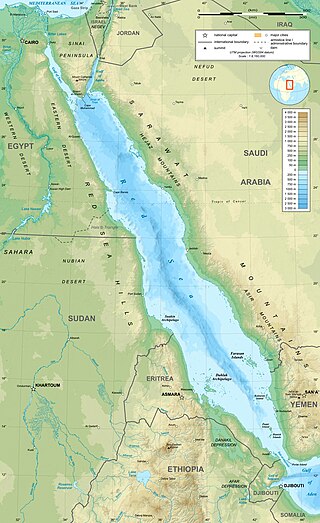
The Red Sea is a sea inlet of the Indian Ocean, lying between Africa and Asia. Its connection to the ocean is in the south, through the Bab-el-Mandeb strait and the Gulf of Aden. To its north lie the Sinai Peninsula, the Gulf of Aqaba, and the Gulf of Suez—leading to the Suez Canal. It is underlain by the Red Sea Rift, which is part of the Great Rift Valley.

The Gulf of St. Lawrence fringes the shores of the provinces of Quebec, New Brunswick, Nova Scotia, Prince Edward Island, Newfoundland and Labrador, in Canada, plus the islands Saint-Pierre and Miquelon, possessions of France, in North America.
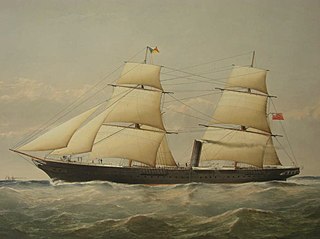
SS Carnatic was a British steamship built in 1862-63 by Samuda Brothers at Cubitt Town on the Isle of Dogs, London, for the Peninsular and Oriental Steam Navigation Company (P&O). She operated on the Suez to Bombay run in the last years before the Suez Canal was opened. This route gave a fast, steamship-operated route from Britain to India, connecting with similar steamships running through the Mediterranean to Alexandria, with an overland crossing to Suez. The alternative was to sail round the Cape of Good Hope, a distance at which steam ships were not, in the early 1860s, sufficiently economical to be commercially competitive with sail.

The Kızılırmak, once known as the Halys River and AlisRiver, is the longest river flowing entirely within Turkey. It is a source of hydroelectric power and is not used for navigation.

The Laptev Sea is a marginal sea of the Arctic Ocean. It is located between the northern coast of Siberia, the Taimyr Peninsula, Severnaya Zemlya and the New Siberian Islands. Its northern boundary passes from the Arctic Cape to a point with co-ordinates of 79°N and 139°E, and ends at the Anisiy Cape. The Kara Sea lies to the west, the East Siberian Sea to the east.

Unimak Island is the largest island in the Aleutian Islands chain of the U.S. state of Alaska.
Farasan Island is the largest island of the Farasan Islands, in the Red Sea. It is located some 50 km (31 mi) offshore from Jizan, the far southwestern part of Saudi Arabia and is among the largest islands in the Red Sea. It is located at 16.7°N 41.0°E. The main town on the island is Farasan. The Farasan island marine sanctuary has been created around the island to protect biodiversity.

A navigational aid (NAVAID), also known as aid to navigation (ATON), is any sort of signal, markers or guidance equipment which aids the traveler in navigation, usually nautical or aviation travel. Common types of such aids include lighthouses, buoys, fog signals, and day beacons.
Akaki is a woreda or district in Oromia Region, Ethiopia. Part of the Oromia Special Zone Surrounding Finfinne, Akaki is bordered on the southwest by the Southwest Shewa Zone, on the west by Sebeta Hawas, on the northwest by Addis Ababa, on the north by the Bereh, and on the east by East Shewa Zone. The administrative center of this woreda is Dukem.

Jabal al-Tair Island is a roughly oval volcanic island in Yemen, northwest of the constricted Bab al-Mandab passage at the mouth of the Red Sea, about halfway between mainland Yemen and Eritrea. From 1996 until an eruption in 2007, Yemen maintained two watchtowers and a small military base on the island.

The Mersey and Irwell Navigation was a river navigation in North West England, which provided a navigable route from the Mersey estuary to Salford and Manchester, by improving the course of the River Irwell and the River Mersey. Eight locks were constructed between 1724 and 1734, and the rivers were improved by the construction of new cuts several times subsequently. Use of the navigation declined from the 1870s, and it was ultimately superseded by the Manchester Ship Canal, the construction of which destroyed most of the Irwell section of the navigation and the long cut between Latchford and Runcorn.

Stewarts Point State Marine Reserve (SMR) and Stewarts Point State Marine Conservation Area (SMCA) are two adjoining marine protected areas that extend offshore from about a mile south of Black Point to Fisk Mill Cove, in Sonoma County on California’s north central coast. The marine protected areas cover 25.22 square miles (65.3 km2). Stewarts Point SMR prohibits the take of all living marine resources. Stewarts Point SMCA prohibits the take of all living marine resources, except recreational shore based take of marine aquatic plants, marine invertebrates, finfish by hook and line, surf smelt by beach net, and species authorized by Title 14 Section 28.80 by hand-held dip net.
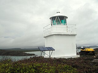
Eborac Island Light is an active lighthouse on Eborac Island, a small rocky island in the Adolphus Channel just off Cape York, the northern tip of Cape York Peninsula, Far North Queensland, Australia. It guides ships into the coastal channel inside the Great Barrier Reef. A concrete structure was built in 1921 and converted to solar power in 1990. It was replaced with a fiberglass structure in 2012.
Parthenina interstincta is a rather widely distributed species of sea snail, a marine gastropod mollusk in the family Pyramidellidae, the pyrams and their allies.
