
Albania is a country in Southeastern Europe that lies along the Adriatic and Ionian Seas, with a coastline spanning approximately 476 km (296 mi). Situated on the Balkan Peninsula, it is one of the most mountainous countries in Europe. It is bounded by Montenegro to the northwest, Kosovo to the northeast, North Macedonia to the east and Greece to the southeast and south.

North Macedonia is a country situated in southeastern Europe with geographic coordinates 41°50′N22°00′E, bordering Kosovo and Serbia to the north, Bulgaria to the east, Greece to the south and Albania to the west. The country is part of the wider region of Macedonia and makes up most of Vardar Macedonia. The country is a major transportation corridor from Western and Central Europe to Southern Europe and the Aegean Sea. North Macedonia is a landlocked country but has three major natural lakes: Lake Ohrid, Lake Prespa and Lake Dojran. It has a water area of 857 km2, while its land area is 24,856 km2.

An estuary is a partially enclosed coastal body of brackish water with one or more rivers or streams flowing into it, and with a free connection to the open sea. Estuaries form a transition zone between river environments and maritime environments and are an example of an ecotone. Estuaries are subject both to marine influences such as tides, waves, and the influx of saline water, and to fluvial influences such as flows of freshwater and sediment. The mixing of seawater and freshwater provides high levels of nutrients both in the water column and in sediment, making estuaries among the most productive natural habitats in the world.

Wetlands, or simply a wetland, is a distinct ecosystem that is flooded or saturated by water, either permanently or seasonally. Flooding results in oxygen-free (anoxic) processes prevailing, especially in the soils. The primary factor that distinguishes wetlands from terrestrial land forms or water bodies is the characteristic vegetation of aquatic plants, adapted to the unique anoxic hydric soils. Wetlands are considered among the most biologically diverse of all ecosystems, serving as home to a wide range of plant and animal species. Methods for assessing wetland functions, wetland ecological health, and general wetland condition have been developed for many regions of the world. These methods have contributed to wetland conservation partly by raising public awareness of the functions some wetlands provide. Constructed wetlands are designed and built to treat municipal and industrial wastewater as well as to divert stormwater runoff. Constructed wetlands may also play a role in water-sensitive urban design.

Struga is a town and popular tourist destination situated in the south-western region of North Macedonia, lying on the shore of Lake Ohrid. The town of Struga is the seat of Struga Municipality.
Freshwater ecosystems are a subset of Earth's aquatic ecosystems. They include lakes, ponds, rivers, streams, springs, bogs, and wetlands. They can be contrasted with marine ecosystems, which have a larger salt content. Freshwater habitats can be classified by different factors, including temperature, light penetration, nutrients, and vegetation. There are three basic types of freshwater ecosystems: Lentic, lotic and wetlands. Freshwater ecosystems contain 41% of the world's known fish species.

Lake Ohrid is a lake which straddles the mountainous border between the southwestern part of North Macedonia and eastern Albania. It is one of Europe's deepest and oldest lakes, with a unique aquatic ecosystem of worldwide importance, with more than 200 endemic species.

The Drin is a river in Southeastern Europe with two major tributaries – the White Drin and the Black Drin and two distributaries – one discharging into the Adriatic Sea, in the Gulf of Drin and the other into the Bojana River. Its catchment area extends across Albania, Kosovo, Serbia, Greece, Montenegro and North Macedonia and is home to more than 1.6 million people. The river and its tributaries form the Gulf of Drin, an ocean basin that encompasses the northern Albanian Adriatic Sea Coast.

The Lake Prespa is located on the tripoint of North Macedonia, Albania, and Greece. It is a system of two lakes separated by an isthmus: the Great Prespa Lake, divided between the three countries, and the Little Prespa Lake, mostly within Greece. They are the highest tectonic lakes in the Balkans, at an elevation of 853 metres (2,799 ft).

The Black Drin, or Black Drim is a river in North Macedonia and Albania. It flows out of Lake Ohrid in Struga, North Macedonia. It is 149 km (93 mi) long and its drainage basin is 3,504 km2 (1,353 sq mi). Its average discharge is 118 m3/s (4,200 cu ft/s). After flowing through North Macedonia for 56 km (35 mi), the Black Drin crosses the border to Albania, west of Debar. It merges with the White Drin in Kukës to form the Drin, which flows into the Adriatic Sea. It drains most of the eastern border region of Albania.

Ohrid trout or the Lake Ohrid brown trout is an endemic species of trout in Lake Ohrid and in its tributaries and outlet, the Black Drin river, in North Macedonia and Albania. Locally, the fish is known as охридска пастрмка in Macedonian and Koran or Korani in Albanian.

Lake Skadar – also called Lake Scutari, Lake Shkodër and Lake Shkodra – lies on the border of Albania and Montenegro, and is the largest lake in Southern Europe. It is named after the city of Shkodër which lies at its southeastern coast. It is a karst lake.

Tourism in North Macedonia is a large factor of the nation's economy. The country's large abundance of natural and cultural attractions make it suitable for tourism.
Brackish marshes develop from salt marshes where a significant freshwater influx dilutes the seawater to brackish levels of salinity. This commonly happens upstream from salt marshes by estuaries of coastal rivers or near the mouths of coastal rivers with heavy freshwater discharges in the conditions of low tidal ranges.
The Rietvlei Wetland Reserve is a 663-hectare (1,640-acre) nature reserve situated in Table View, Western Cape, South Africa. It is managed by the City of Cape Town's Environmental Resource Management Department.

For a small country, Albania is characterised by a considerable wealth of terrestrial and marine ecosystems and habitats with contrasting floral, faunal, and fungal species, defined in an area of 28,748 square kilometres. Most of the country is predominantly of Mediterranean character, comprehending the country's center and south, while the alpine affinity is more visible in the northeast.

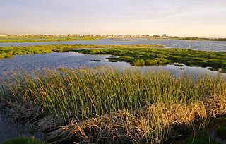
Prespa National Park is a national park situated in southeastern Albania on the border triangle shared with Greece and North Macedonia. At approximately 277.5 km2 (107.1 sq mi), the park encompasses the country's sections of the Great and Small Prespa Lake. It is considerably characterised by high mountains, narrow islands, vast freshwater wetlands, salt marshes, meadows, reed beds and dense forests.

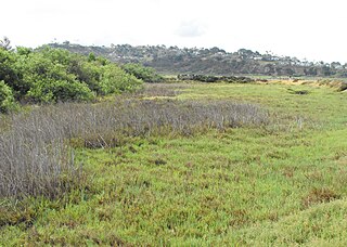
Studenchishte Marsh is the last remains of a previously extensive wetland habitat on the eastern shore of ancient Lake Ohrid in North Macedonia. It is also the final major coastline wetland at Lake Ohrid and one of only seven marshes with relict communities that still exist in North Macedonia. With several millennia of natural history, it is a site of key conservation interest and part of the Lake Ohrid Wetland of International Importance under the Ramsar Convention.
Niko Nestor was a Macedonian amateur open water swimmer. He was also a water polo player.
Over 22,500 species of wildlife have been recorded in North Macedonia. Over 10,000 of these are insects, which include 3,000 beetle species and large numbers of Lepidoptera, flies, and Hymenoptera. Aside from insects, other large arthropod groups include Chelicerata and crustaceans. Among vertebrates, more than 300 species of birds recorded, although not all nest in the country. There are over 80 species of both fish and mammals, 32 reptiles, and 14 amphibians.

