
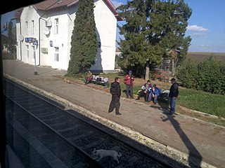
Satu Mare railway station is the main station in Satu Mare, Romania. It is located near the city center. The station was first constructed in 1870; the current building dates from 1899 and was designed by the architect Ferenc Pfaff. [1]
Satu Mare railway station is the main station in Satu Mare, Romania. It is located near the city center. The station was first constructed in 1870; the current building dates from 1899 and was designed by the architect Ferenc Pfaff. [1]
The station is situated on the Căile Ferate Române Line 400 (Brașov - Siculeni – Deda – Dej – Baia Mare – Satu Mare), [2] on Line 402 (Oradea – Săcueni – Carei – Satu Mare – Halmeu) [2] and on Line 417 (Satu Mare – Bixad). [2] The Romanian Railways (CFR) provide direct rail connections to all the major Romanian cities and to Budapest. [2] As of 2008, Satu Mare railway station serves about 54 passenger trains, including domestic trains operated by Căile Ferate Române. [2]
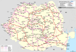
Căile Ferate Române is the state railway carrier of Romania. As of 2014, the railway network of Romania consists of 10,777 km (6,697 mi), of which 4,029 km (2,504 mi) (37.4%) are electrified. The total track length is 22,247 km (13,824 mi), of which 8,585 km (5,334 mi) (38.5%) are electrified. The CIA World Factbook lists Romania with the 23rd largest railway network in the world. The network is significantly interconnected with other European railway networks, providing pan-European passenger and freight services. CFR as an entity has been operating since 1880, even though the first railway on current Romanian territory was opened in 1854. CFR is divided into four autonomous companies:

Satu Mare is a city with a population of 102,400 (2011). It is the capital of Satu Mare County, Romania, as well as the centre of the Satu Mare metropolitan area. It lies in the region of Maramureș, broadly part of Transylvania. Mentioned in the Gesta Hungarorum as castrum Zotmar, the city has a history going back to the Middle Ages. Today, it is an academic, cultural, industrial, and business centre in the Nord-Vest development region.

Beclean is a town in Bistrița-Năsăud County, in north-eastern Transylvania, Romania. The town administers three villages: Coldău, Figa (Füge), and Rusu de Jos (Alsóoroszfalu).

Pașcani is a city in Iași County in the Western Moldavia region of Romania, on the Siret river. As of 2011, it has a population of 33,745. Five villages are administered by the city: Blăgești, Boșteni, Gâstești, Lunca, and Sodomeni.
The first railway in the Kingdom of Romania opened in 1869 and linked Bucharest and Giurgiu. The first railway on electric current in the current Romanian territory opened in 1854, between Oravița and Baziaș in Banat, right next to the border with Serbia; however, that region was under the administration of the Austrian Empire at the time, and became part of Romania after World War I.

Basarab railway station in Bucharest is situated near the city's main station, Gara de Nord. Built in 1959 to handle a share of the main station's traffic and mainly used by short-distance commuter trains run by Căile Ferate Române, it is often considered to be an annex of Gara de Nord, to which it is linked by a footbridge.

Titan Sud is a small train station located in the Eastern side of Bucharest, Romania, near the Republica metro station and the Republica Factory.

Cluj-Napoca train station is the main railway station in Cluj-Napoca, Romania. It is located near the city center.
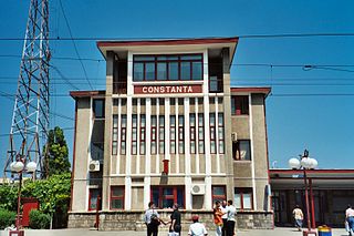
Constanţa railway station is the largest station in Constanţa and on the Romanian Black Sea coast.

Timișoara North railway station is the main railway station in Timișoara and also the largest railway station in western Romania. With an average daily ridership of about 5,530 passengers, Timișoara North is one of the busiest railway stations in Romania.
The Brașov railway station is the main station in Brașov, Romania. The building on the current location was opened to traffic in 1962. The station's bell chimes preceding the announcements represent a few notes from Ciprian Porumbescu's operetta Crai Nou.
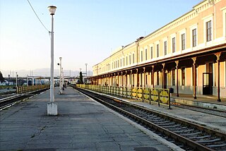
Sibiu railway station is the main railway station in Sibiu, Romania.
Faraoani is a commune in Bacău County, Western Moldavia, Romania. It is composed of two villages, Faraoani and Valea Mare (Nagypatak).
The nine main lines owned by the Romanian national rail transport company Căile Ferate Române represent the most circulated lines in Romania. CFR's entire rail networks has 13,807 km (8,579 mi) and with the 6,923 km (4,302 mi) of rail lines in railway stations has a total network of 20,730 km (12,880 mi).

Line 300 is one of Căile Ferate Române's main lines in Romania, having a total length of 647 kilometres (402 mi). The main line, connecting Bucharest with the Hungarian border near Oradea, passes through Ploiești, Brașov, Sighișoara, Teiuș, and Cluj-Napoca. The section between Bucharest and Ploiești is shared with CFR line 500.

CFR Marfă is the state-owned freight railway business of Romania.

The Agnita railway line was a 760 mmBosnian gauge rail line in Sibiu County, Romania. Originally it ran from Sibiu railway station to Sighișoara in Mureș County. There also was a branch line to Vurpăr. However the final section from Sibiu to Agnita was closed in 2001. Căile Ferate Române (CFR) classed the line, along with the Vurpăr branch, as line 204 in the last years of operation. The Sibiu Steam Locomotives Museum holds the last remaining original locomotive from 1896.

Romania is an international passenger train running daily from Bucharest, Romania to Sofia, Bulgaria. During summer months, the train operates together with the Bosphorus Express from Bucharest to Gorna Oryahovica, where the latter heads southeast toward Istanbul, Turkey. Romania is operated by two national railway operators: Căile Ferate Române and the Bulgarian State Railways.
Vicșani is a railway station near the town of Siret in Suceava County of northern Romania, 7km south of the Ukrainian border, on the line north from Bucharest.

Valea Vișeului is a railway station near the town of Valea Vișeului in Bistra commune, Maramureș County of western Romania, close to the Ukraine border.
| Places of worship |  | |
|---|---|---|
| Historical buildings | ||
| Statues and monuments | ||
| Bridges | ||
| Sports venues | ||
| Other buildings | ||
47°47′43.48″N22°53′36.28″E / 47.7954111°N 22.8934111°E
| | This article about a Romanian railway station is a stub. You can help Wikipedia by expanding it. |