Related Research Articles

Traffic on roads consists of road users including pedestrians, ridden or herded animals, vehicles, streetcars, buses and other conveyances, either singly or together, while using the public way for purposes of travel.
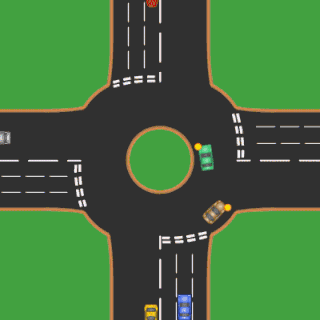
A roundabout is a type of circular intersection or junction in which road traffic is permitted to flow in one direction around a central island, and priority is typically given to traffic already in the junction.

A ramp meter, ramp signal, or metering light is a device, usually a basic traffic light or a two-section signal light together with a signal controller, that regulates the flow of traffic entering freeways according to current traffic conditions. Ramp meters are used at freeway on-ramps to manage the rate of automobiles entering the freeway. Ramp metering systems have proved to be successful in decreasing traffic congestion and improving driver safety.

An intersection is an at-grade junction where two or more transport flows meet or cross. Intersections may be classified by number of road segments, traffic controls or lane design. In general, intersections are either signalized or priority (unsignalized).
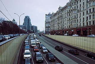
Traffic congestion is a condition in transport that is characterised by slower speeds, longer trip times, and increased vehicular queueing. Traffic congestion on urban road networks has increased substantially, since the 1950s. When traffic demand is great enough that the interaction between vehicles slows the speed of the traffic stream, this results in some congestion. While congestion is a possibility for any mode of transportation, this article will focus on automobile congestion on public roads.

In the field of road transport, an interchange is a road junction that uses grade separation, and typically one or more ramps, to permit traffic on at least one highway to pass through the junction without interruption from other crossing traffic streams. It differs from a standard intersection, where roads cross at grade. Interchanges are almost always used when at least one road is a controlled-access highway or a limited-access divided highway (expressway), though they are sometimes used at junctions between surface streets.
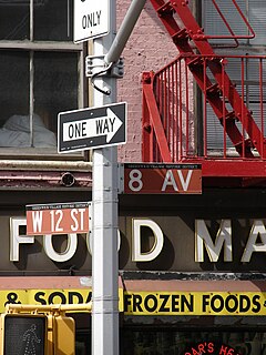
One-way traffic is traffic that moves in a single direction. A one-way street is a street either facilitating only one-way traffic, or designed to direct vehicles to move in one direction. One-way streets typically result in higher traffic flow as drivers may avoid encountering oncoming traffic or turns through oncoming traffic. Residents may dislike one-way streets due to the circuitous route required to get to a specific destination, and the potential for higher speeds adversely affecting pedestrian safety. Some studies even challenge the original motivation for one-way streets, in that the circuitous routes negate the claimed higher speeds.
In mathematics and transportation engineering, traffic flow is the study of interactions between travellers and infrastructure, with the aim of understanding and developing an optimal transport network with efficient movement of traffic and minimal traffic congestion problems.
Annual average daily traffic, abbreviated AADT, is a measure used primarily in transportation planning, transportation engineering and retail location selection. Traditionally, it is the total volume of vehicle traffic of a highway or road for a year divided by 365 days. AADT is a simple, but useful, measurement of how busy the road is.

The GEH Statistic is a formula used in traffic engineering, traffic forecasting, and traffic modelling to compare two sets of traffic volumes. The GEH formula gets its name from Geoffrey E. Havers, who invented it in the 1970s while working as a transport planner in London, England. Although its mathematical form is similar to a chi-squared test, is not a true statistical test. Rather, it is an empirical formula that has proven useful for a variety of traffic analysis purposes.
A junction is where two or more roads meet.
Passenger Car Equivalent (PCE) or Passenger Car Unit (PCU) is a metric used in Transportation Engineering, to assess traffic-flow rate on a highway.

Lane splitting is riding a bicycle or motorcycle between lanes or rows of slow moving or stopped traffic moving in the same direction. It is sometimes called whitelining, or stripe-riding. This allows riders to save time, bypassing traffic congestion, and may also be safer than stopping behind stationary vehicles.
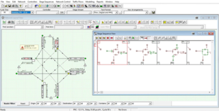
LinSig is a software tool by JCT Consultancy which allows traffic engineers to model traffic signals and their effect on traffic capacities and queuing. As well as modelling the effects of traffic signals LinSig also optimises signal timings to reduce delay or increase capacity at a junction or group of interlinked junctions.

Traffic simulation or the simulation of transportation systems is the mathematical modeling of transportation systems through the application of computer software to better help plan, design, and operate transportation systems. Simulation of transportation systems started over forty years ago, and is an important area of discipline in traffic engineering and transportation planning today. Various national and local transportation agencies, academic institutions and consulting firms use simulation to aid in their management of transportation networks.

Cycling infrastructure refers to all infrastructure permissible for use by cyclists, including the network of roads and streets used by motorists, except where cyclists are excluded, along with bikeways from which motor vehicles are excluded – including bike paths, bike lanes, cycle tracks, rail trails and, where permitted, sidewalks. Cycling infrastructure also includes amenities such as bike racks for parking, shelters, service centers and specialized traffic signs and signals. Cycling modal share is strongly associated with the size of local cycling infrastructure.
Sidra Intersection is a software package used for intersection (junction) and network capacity, level of service and performance analysis, and signalised intersection and network timing calculations by traffic design, operations and planning professionals.

Terminology related to road transport—the transport of passengers or goods on paved routes between places—is diverse, with variation between dialects of English. There may also be regional differences within a single country, and some terms differ based on the side of the road traffic drives on. This glossary is an alphabetical listing of road transport terms.
Junctions is a software package by Transport Research Laboratory. It incorporates the previously separate programs ARCADY, PICADY and OSCADY. The latest version, Junctions 10, was launched Wednesday 3 February 2021.

TRANSYT is traffic engineering software developed by the Transport Research Laboratory. It is used to model signalised highway networks and has the ability to model platooning.
References
- ↑ DfT Traffic Signs Manual https://assets.publishing.service.gov.uk/government/uploads/system/uploads/attachment_data/file/851465/dft-traffic-signs-manual-chapter-6.pdf
- ↑ Kimber R M, Macdonald M & Hounsell N B, The Prediction of Saturation Flows for Road Junctions Controlled by Traffic Signals, Transport and Road Research Laboratory, Department of Transport, Research Report 67, 1986. https://www.eastleigh.gov.uk/media/8592/cd58.pdf
- ↑ TfL Modelling Guidelines v3.0, paragraph 2.4.7.1, http://content.tfl.gov.uk/traffic-modelling-guidelines.pdf
- ↑ The Norfolk County Council (Norwich Northern Distributor Road (A1067 to A47(T))) Order - NCC/EX/3 Glossary of Terms https://www.norfolk.gov.uk/-/media/norfolk/downloads/roads-and-transport/ndr/post-submission-documents/nccex3-glossary-of-terms.pdf?la=en
- ↑ Essex Highways - Epping Forest Local Plan Highway Impact Assessment https://www.efdclocalplan.org/wp-content/uploads/2017/11/Essex-Highways-Tech-Note-1-Base-year-junction-capacity-modelling-Oct-2013-EB500A.pdf