Related Research Articles

Nigeria is a country in West Africa. Nigeria shares land borders with the Republic of Benin in the west, Chad and Cameroon in the east, and Niger in the north. Its coast lies on the Gulf of Guinea in the south and it borders Lake Chad to the northeast. Noted geographical features in Nigeria include the Adamawa Plateau, Mambilla Plateau, Jos Plateau, Obudu Plateau, the Niger River, Benue River, and Niger Delta.
The Appalachian National Scenic Trail, generally known as the Appalachian Trail or simply the A.T., is a marked hiking trail in the Eastern United States extending between Springer Mountain in Georgia and Mount Katahdin in Maine. The trail passes through 14 states and is about 2,200 miles (3,500 km) long, though the exact length changes over time as parts are rerouted or modified. The Appalachian Trail Conservancy describes the Appalachian Trail as the longest hiking-only trail in the world. More than two million people are said to take a hike on part of the trail at least once each year.

Warren County is a county located in the U.S. state of New Jersey. As of the 2020 United States census, the county's population was 109,632, representing an increase of 940 (0.9%) from the 108,692 residents counted at the 2010 U.S. Census. It is one of four counties that comprise the Lehigh Valley region of the United States. Its county seat is Belvidere.

The Savannah River is a major river in the southeastern United States, forming most of the border between the states of South Carolina and Georgia. Two tributaries of the Savannah, the Tugaloo River and the Chattooga River, form the northernmost part of the border. The Savannah River drainage basin extends into the southeastern side of the Appalachian Mountains just inside North Carolina, bounded by the Eastern Continental Divide. The river is around 301 miles (484 km) long. The Savannah was formed by the confluence of the Tugaloo River and the Seneca River. Today this confluence is submerged beneath Lake Hartwell. The Tallulah Gorge is located on the Tallulah River, a tributary of the Tugaloo River that forms the northwest branch of the Savannah River.
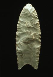
Clovis points are the characteristically fluted projectile points associated with the New World Clovis culture, a prehistoric Paleo-American culture. They are present in dense concentrations across much of North America and they are largely restricted to the north of South America. Clovis points date to the Early Paleoindian period, with all known points dating from roughly 13,500 to 12,800 years ago. Clovis fluted points are named after the city of Clovis, New Mexico, where examples were first found in 1929 by Ridgely Whiteman.

Homo antecessor is an archaic human species recorded in the Spanish Sierra de Atapuerca, a productive archaeological site, from 1.2 to 0.8 million years ago during the Early Pleistocene. Populations of this species may have been present elsewhere in Western Europe, and were among the first to colonise that region of the world. The first fossils were found in the Gran Dolina cave in 1994, and the species was formally described in 1997 as the last common ancestor of modern humans and Neanderthals, supplanting the more conventional H. heidelbergensis in this position. H. antecessor has since been reinterpreted as an offshoot, though probably one branching off just before the modern human/Neanderthal split.
Neville is an archaeological site on the east bank of the Merrimack River in Manchester, New Hampshire in the United States.

The Poverty Point culture is the archaeological culture of a prehistoric indigenous peoples who inhabited a portion of North America's lower Mississippi Valley and surrounding Gulf coast from about 1730 - 1350 BC.
The Big Eddy Site (23CE426) is an archaeological site located in Cedar County, Missouri, which was first excavated in 1997 and is now threatened due to erosion by the Sac River.

Mialoquo is a prehistoric and historic Native American site in Monroe County, Tennessee, in the southeastern United States. The site saw significant periods of occupation during the Mississippian period and later as a Cherokee refugee village. While the archaeological site of Mialoquo was situated on the southwest bank of the Little Tennessee River, the village's habitation area probably included part of Rose Island, a large island in the river immediately opposite the site. Rose Island was occupied on at least a semi-permanent basis as early as the Middle Archaic period.

The Thunderbird Archaeological District, near Limeton, Virginia, is an archaeological district described as consisting of "three sites—Thunderbird Site, the Fifty Site, and the Fifty Bog—which provide a stratified cultural sequence spanning Paleo-Indian cultures through the end of Early Archaic times with scattered evidence of later occupation."
The Prehistory of West Virginia spans ancient times until the arrival of Europeans in the early 17th century. Hunters ventured into West Virginia's mountain valleys and made temporary camp villages since the Archaic period in the Americas. Many ancient human-made earthen mounds from various mound builder cultures survive, especially in the areas of Moundsville, South Charleston, and Romney. The artifacts uncovered in these areas give evidence of a village society with a tribal trade system culture that included limited cold worked copper. As of 2009, over 12,500 archaeological sites have been documented in West Virginia.
J&J Hunt Site (8JE740) is an inundated prehistoric archaeological site located 6 km off the coast of northwestern Florida. The site which was discovered in 1989 is located in 3.7 to 4.6 m of salt water in the Gulf of Mexico along the PaleoAucilla River. In prehistory the site had at least two different occupations: a Late Paleoindian-Early Archaic and Middle Archaic. The J&J Hunt site was a major focus of the PaleoAucilla Prehistory Project conducted by Michael K. Faught.

The Broad River is a 60.0-mile-long (96.6 km) tributary of the Savannah River in northeastern Georgia. The North Fork of the Broad River begins in the foothills of the Appalachian Mountains in Stephens County, then joins the Middle Fork west of Royston in Franklin County to form the main stem. The Broad River continues south, being joined by the Hudson River flowing from the west out of Franklin County. The Broad was used for reference as the county line between Madison and Elbert counties as it turns southeast.

Prehistory of Ohio provides an overview of the activities that occurred prior to Ohio's recorded history. The ancient hunters, Paleo-Indians, descended from humans that crossed the Bering Strait. There is evidence of Paleo-Indians in Ohio, who were hunter-gatherers that ranged widely over land to hunt large game. For instance, mastodon bones were found at the Burning Tree Mastodon site that showed that it had been butchered. Clovis points have been found that indicate interaction with other groups and hunted large game. The Paleo Crossing Site and [[Nobles Pond Site Tools, like spear-throwers, were more sophisticated. Base camps were established for winter lodging. The Glacial Kame culture, a late Archaic group, traded for sea shell and copper with other groups and were used as a sign of prestige within the group, for respected healers and hunters. The objects were buried with their owners.

Amanita flavoconia, commonly known as yellow patches, yellow wart, orange amanita, yellow-dust amanita or the American yellow dust amanita, is a species of mushroom in the family Amanitaceae. It has an orangish-yellow cap with yellowish-orange patches or warts, a yellowish-orange annulus, and a white to orange stem. Common and widespread throughout eastern North America, Amanita flavoconia grows on the ground in broad-leaved and mixed forests, especially in mycorrhizal association with hemlock.
The Bare Island projectile point is a stone projectile point of prehistoric indigenous peoples of North America. It was named by Fred Kinsey in 1959 for examples recovered at the Kent-Halley site on Bare Island in Pennsylvania.

Many local variants of the Greek alphabet were employed in ancient Greece during the archaic and early classical periods, until around 400 BC, when they were replaced by the classical 24-letter alphabet that is the standard today. All forms of the Greek alphabet were originally based on the shared inventory of the 22 symbols of the Phoenician alphabet, with the exception of the letter Samekh, whose Greek counterpart Xi (Ξ) was used only in a sub-group of Greek alphabets, and with the common addition of Upsilon (Υ) for the vowel. The local, so-called epichoric, alphabets differed in many ways: in the use of the consonant symbols Χ, Φ and Ψ; in the use of the innovative long vowel letters, in the absence or presence of Η in its original consonant function ; in the use or non-use of certain archaic letters ; and in many details of the individual shapes of each letter. The system now familiar as the standard 24-letter Greek alphabet was originally the regional variant of the Ionian cities in Anatolia. It was officially adopted in Athens in 403 BC and in most of the rest of the Greek world by the middle of the 4th century BC.

Golondrina points are lanceolate spear or dart projectile points, of medium size, dated to the transitional Paleo-Indian Period, between 9000–7000 BP. Golondrina points were attached on split-stem hafts and may have served to bring down medium-sized animals such as deer, as well as functioning as butchering knives. Distribution is widespread throughout most of Texas, and points have also been discovered in Arkansas and Mexico. The concentration of Golondrina specimens is highest across the South Texas Plains, where the point is the most prevalent of Paleo-Indian types and defines a distinctive cultural pattern for the region. The Golondrina point is so named for its flared basal corners ("ears"), which resemble a swallow's split tail. Classification of Golondrina can be difficult because of its similarity to other types, particularly the Plainview point, to which it was originally thought to be related.
Rucker's Bottom Site (9EB91) is an archaeological site in located on the Upper Savannah River in Elbert County, Georgia.
References
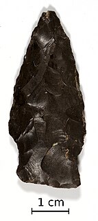
- ↑ "Savannah River". Virginia Department of Historic Resources - Points. 2022. Archived from the original on December 9, 2021. Retrieved May 2, 2022.
- ↑ "Savannah River". Diagnostic Artifacts in Maryland. December 30, 2012. Archived from the original on February 6, 2022. Retrieved May 2, 2022.
- ↑ Bissett, Thaddeus G.; Garrow, Patrick H. (2016). "The Long Branch Site (31JK477): A Late Archaic Savannah River Phase Occupation in the Appalachian Summit of Western North Carolina". Archaeology of Eastern North America. 44: 57–58. JSTOR 44808364.