The Savory brittleness scale is used to describe the position on a simple 1 to 10 scale of any environment based upon the distribution of humidity throughout each year, to assist with management decisions. It was developed by Allan Savory, a Zimbabwean biologist, because scientists were only recognizing desertification taking place in low rainfall or “fragile” environments. Savory recognized that desertification was the extreme or terminal form of man-made land degradation, but that this began with simple biodiversity loss that was occurring at all levels of rainfall from high to low. Fragile environments did not cover the situation because Savory thought all environments were fragile. The scale is used in land management because the annual distribution of humidity affects the way entire biological communities function on the land, and in particular to conservation or resting the environment to maintain or restore biodiversity. He also noted that the distribution of humidity and thus position on the brittleness scale influenced the effects of such things as fire and grazing by large herbivores.
The scale ranges from 1 to 10 with 1 being non-brittle and 10 being very brittle. The scale is subjective; there is no formula for its calculation. A tropical rainforest is considered a 1 on the scale, and an arid desert such as the Namib or Gobi is considered a 10.
Position on the scale is determined not from rainfall records but from field observation because humidity is influenced by several factors such as altitude of prevailing winds. Savory used the term brittleness because an easy practical observation is whether or not a dead grass stem or small dead twig is soft and easily bent by hand or so brittle it snaps. For these reasons it differs from an aridity index. Thus, some high rainfall environments, e.g., Zambia, with 2,000 mm annual rainfall and distinct wet and dry seasons, is higher on the brittleness scale because of the long portions of the year without rainfall. An environment with lower total rainfall distributed fairly evenly throughout the year, such as parts of England with 600 mm annually, are lower on the brittleness scale.
Grass leaves and stems that die off above ground every year following the growing season break down slowly and mainly through oxidation in sunlight and physical weathering in the more brittle environments. And trees dying in such environments tend to remain standing for many years again gradually breaking down through oxidation and weathering from the top down. At the opposite end of the scale, where humidity distribution is more even, dead plant material tends to break down rapidly through high micro-organism activity or biological decay. Commonly a dead tree will decay at the base, fall and decay on the ground. Other observations Savory made were that at the lower end of the scale most herbivores naturally were insects with few large herbivores and solitary predators, while moving toward the higher end large herding herbivores and pack-hunting predators increased.
The effect of resting the environment to allow recovery and maintenance of biodiversity is different across the brittleness scale. At the low end resting the environment as in establishing wilderness or conservation is the most powerful action possible to restore biodiversity. Moving across the scale the same practice can become increasingly damaging to the health of entire communities. This is why Savory argued that abandoned cities of past ages low on the scale are today found under recovered tropical forest, while abandoned cities at the other end in former savannas are today found under desert sands. Total protection by removing all livestock leads to recovery of biodiversity in the perennially humid environments in the US, but the same practice in places such as New Mexico has led to severe desertification.
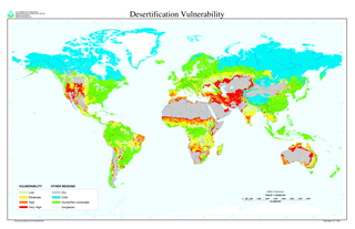
Desertification is a type of land degradation in drylands involving loss of biological productivity caused by natural processes or induced by human activities. It is caused by a variety of factors, such as through climate change and through the overexploitation of soil through human activity. When deserts appear automatically over the natural course of a planet's life cycle, then it can be called a natural phenomenon; however, when deserts emerge due to the rampant and unchecked depletion of nutrients in soil that are essential for it to remain arable, then a virtual "soil death" can be spoken of, which traces its cause back to human overexploitation. Desertification is a significant global ecological and environmental problem with far reaching consequences on socio-economic and political conditions.
Overgrazing occurs when plants are exposed to intensive grazing for extended periods of time, or without sufficient recovery periods. It can be caused by either livestock in poorly managed agricultural applications, game reserves, or nature reserves. It can also be caused by immobile, travel restricted populations of native or non-native wild animals. However, "overgrazing" is a controversial concept, based on equilibrium system theory.

The Tropic of Capricorn is the circle of latitude that contains the subsolar point on the December solstice. It is thus the southernmost latitude where the Sun can be directly overhead. Its northern equivalent is the Tropic of Cancer.

Deserts and xeric shrublands are a habitat type defined by the World Wide Fund for Nature. Deserts and xeric shrublands form the largest terrestrial biome, covering 19% of Earth's land surface area. Ecoregions in this habitat type vary greatly in the amount of annual rainfall they receive, usually less than 250 millimetres (10 in) annually. Generally evaporation exceeds rainfall in these ecoregions. Temperature variability is also diverse in these lands. Many deserts, such as the Sahara, are hot year-round but others, such as Asia's Gobi, become quite cold in winter.
Tropical and subtropical grasslands, savannas, and shrublands is a terrestrial habitat type defined by the World Wide Fund for Nature. The biome is dominated by grass and/or shrubs located in semi-arid to semi-humid climate regions of subtropical and tropical latitudes.
In agriculture, grazing is a method of animal husbandry whereby domestic livestock are used to convert grass and other forage into meat, milk, wool and other products, often on land unsuitable for arable farming.

Worldwide more human beings gain their livelihood from agriculture than any other endeavor; the majority are self-employed subsistence farmers living in the tropics. While growing food for local consumption is the core of tropical agriculture, cash crops are also included in the definition.
The major environmental issues in Kyrgyzstan are summarized in the 2007 Concept of Ecological Security of Kyrgyz Republic and discussed in other environmental and environmental policy documents such as National Environmental Action Plan (1995), Country Development Strategy for 2009–2011, Strategy on Biological Diversity (2002), 2nd Environmental Performance Review of Kyrgyzstan (2008), etc.

Prairie restoration is a conservation effort to restore prairie lands that were destroyed due to industrial, agricultural, commercial, or residential development. For example, the U.S. state of Illinois alone once held over 35,000 square miles (91,000 km2) of prairie land and now just 3 square miles (7.8 km2) of that original prairie land is left.
An aridity index (AI) is a numerical indicator of the degree of dryness of the climate at a given location. A number of aridity indices have been proposed ; these indicators serve to identify, locate or delimit regions that suffer from a deficit of available water, a condition that can severely affect the effective use of the land for such activities as agriculture or stock-farming.

Yatir Forest is a forest in Israel, located on the southern slopes of Mount Hebron, on the edge of the Negev Desert. The forest covers an area of 30,000 dunams, and is the largest planted forest in Israel.

Clifford Allan Redin Savory is a Zimbabwean ecologist, livestock farmer, and president and co-founder of the Savory Institute. He originated Holistic management (agriculture), a systems thinking approach to managing resources.
Range Condition Scoring was developed as a way to quantify biodiversity in a given rangeland system. This practice is widely used in the Sand Hills region of Nebraska, as well as the tallgrass prairie regions, as evidenced by the authoritative book on the subject, "Range Judging Handbook and Contest Guide for Nebraska." This book outlines the steps required to evaluate, or score, a particular region of rangeland; and it serves as a baseline for the understanding of this method of judging rangeland health.

The environmental impact of agriculture is the effect that different farming practices have on the ecosystems around them, and how those effects can be traced back to those practices. The environmental impact of agriculture varies based on the wide variety of agricultural practices employed around the world. Ultimately, the environmental impact depends on the production practices of the system used by farmers. The connection between emissions into the environment and the farming system is indirect, as it also depends on other climate variables such as rainfall and temperature.
Drylands are defined by a scarcity of water. Drylands are zones where precipitation is balanced by evaporation from surfaces and by transpiration by plants (evapotranspiration). The United Nations Environment Program defines drylands as tropical and temperate areas with an aridity index of less than 0.65. One can classify drylands into four sub-types:

Holistic management in agriculture is an approach to managing resources that was originally developed by Allan Savory.

Holistic Management International (HMI) is a not-for-profit organization promoting holistic management in agriculture, based in Albuquerque, New Mexico. It maintains an international network of educators and "land stewards" who "use holistic management strategies to manage more than 30 million acres around the globe".

Regenerative agriculture is a conservation and rehabilitation approach to food and farming systems. It focuses on topsoil regeneration, increasing biodiversity, improving the water cycle, enhancing ecosystem services, supporting biosequestration, increasing resilience to climate change, and strengthening the health and vitality of farm soil. Practices include, recycling as much farm waste as possible, and adding composted material from sources outside the farm.
The conservation and restoration of frescoes is the process of caring for and maintaining frescos, and includes documentation, examination, research, and treatment to insure their long-term viability, when desired.

Soil regeneration, as a particular form of ecological regeneration within the field of restoration ecology, is creating new soil and rejuvenating soil health by: minimizing the loss of topsoil, retaining more carbon than is depleted, boosting biodiversity, and maintaining proper water and nutrient cycling. This has many benefits, such as: soil sequestration of carbon in response to a growing threat of climate change, a reduced risk of soil erosion, and increased overall soil resilience.