Sayun District

Last updated
Sayun District
Country Flag of Yemen.svg  Yemen
Governorate Hadhramaut
Population
 (2003)
  Total102,409
Time zone UTC+3 (Yemen Standard Time)

Sayun District is a district of the Hadhramaut Governorate, Yemen. As of 2003, the district had a population of 102,409 inhabitants. [1]

Hadhramaut Governorate Governorate in Republic of Yemen

Hadhramaut or Hadramawt is a governorate of Yemen. Lying within the large historical region of Hadhramaut, it is the country's largest governorate.

Yemen Republic in Western Asia

Yemen , officially the Republic of Yemen, is a country at the southern end of the Arabian Peninsula in Western Asia. It is the second-largest Arab sovereign state in the peninsula, occupying 527,970 square kilometres. The coastline stretches for about 2,000 kilometres. It is bordered by Saudi Arabia to the north, the Red Sea to the west, the Gulf of Aden and Guardafui Channel to the south, and the Arabian Sea and Oman to the east. Yemen's territory includes more than 200 islands. Yemen is a member of the Arab League, United Nations, Non-Aligned Movement and the Organisation of Islamic Cooperation.Yemen also owns the largest island in all of the Middle East which is called the most alien looking place on Earth called Socotra.

Contents

Geography

Sayun District is about 804 square kilometers wide. The district is located in the central part of Hadhramaut and Wadi Hadhramaut. It is bordered to the south by Tarim and Sah Districts, and to the west by Shibam District. Siyoun District is about 320 kilometers from the provincial capital Mukalla. As for the terrain, the district consists of a relatively flat surface that forms a part of Wadi Hadhramaut surrounded by mountain ranges from the northern and southern sides leading to the northern and southern plateaus. These mountain ranges also penetrate several sub-valleys of Hadhramaut Valley, Wadi Bin Salman in Batarab and the northern part of Wadi Madr Bbour.

Tarim District is a district of the Hadhramaut Governorate, Yemen. As of 2003, the district had a population of 100,617 inhabitants with Tarim as its biggest city.

Sah District is a district of the Hadhramaut Governorate, Yemen. As of 2003, the district had a population of 24,146 people.

Shibam District is a district of the Hadhramaut Governorate, Yemen. Its capital is the town of Shibam, famous for its mudbrick-made tower houses. As of 2003, the district had a population of 48,829 inhabitants.

Demographics

The population of the district is estimated as 111,728 inhabitants according to the population projections in 2004 based on the annual population growth rate of Hadhramaut Governorate which is 4.33%, and the population density is about 139 inhabitants / km2. The population centers are concentrated in the city and its suburbs, and urban ratio is 47.4% and rural areas consists 52.6%. In general, the population of the district is 10.9% of the total population of the governorate and 14.3% of the population of the whole valley and the desert.

Related Research Articles

Geography of Yemen

Yemen is located in Southwest Asia, at the southern tip of the Arabian Peninsula, between Oman and Saudi Arabia. It is situated at the entrance to the Bab-el-Mandeb Strait, which links the Red Sea to the Indian Ocean and is one of the most active and strategic shipping lanes in the world. Yemen has an area of 527,970 square kilometres (203,850 sq mi), including the islands of Perim at the southern end of the Red Sea and Socotra at the entrance to the Gulf of Aden. Yemen's land boundaries total 1,746 kilometres (1,085 mi). Yemen borders Saudi Arabia to the north and Oman to the northeast.

Seiyun Place in Hadhramaut, Yemen

Say'un — — is a city in the region and Governorate of Hadhramaut in Yemen. It is located in the middle of the Hadhramaut Valley, about 360 km (220 mi) from Mukalla, the capital of Mukalla District and the largest city in the area, via western route. It is also 12 km (7.5 mi) away from Shibam and 35 km (22 mi) away from Tarim, other large cities in the valley.

Mukalla Place in Hadramaut, Yemen

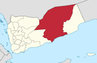
Mukalla is a seaport and the capital city of Yemen's largest governorate, Hadhramaut. The city is located in the southern part of the Arabian Peninsula on the Gulf of Aden, on the shores of the Arabian Sea, about 480 kilometres east of Aden. It is the most important port in the Hadhramaut, and the fifth-largest city in Yemen, with a population of approximately 300,000. The city is served by the nearby Riyan Airport.

Al Mahrah Governorate Governorate in Yemen

Al Mahrah, or simply Mahra, is a governorate (muhafazah) of Yemen in the southern part of the Arabian Peninsula. Situated in the area of the former Mahra Sultanate, its capital is Al Ghaydah, and it has international borders with Saudi Arabia and Oman.

Wadi Dawan Place in Hadhramaut, Yemen

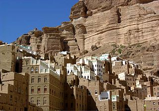
Wadi Dawan is a town and desert valley in central Yemen. Located in the Hadhramaut Governorate, it is noted for its mud brick buildings.

Huraidhah District is a district of the Hadhramaut Governorate, Yemen. As of 2003, the district had a population of 18,684 inhabitants.

Rakhyah District is a district of the Hadhramaut Governorate, Yemen. As of 2003, the district had a population of 8,715 inhabitants.

Thamud District is a district of the Hadhramaut Governorate, Yemen. As of 2003, the district had a population of 4,402 inhabitants.

Hawrah District is a district of the Hadhramaut Governorate, Yemen. As of 2003, the district had a population of 28,474 inhabitants.

Yabuth District is a district of the Hadhramaut Governorate, Yemen. As of 2003, the district had a population of 9,862 inhabitants.

Zamakh wa Manwakh District is a district of the Hadhramaut Governorate, Yemen. As of 2003, the district had a population of 1,505 inhabitants.

Bayhan District District in Shabwah, Yemen

Bayhan District is a district of the Shabwah Governorate in Yemen. As of 2003, the district had a population of 48,347 inhabitants.

Kafr Ram Town in Homs, Syria

Kafr Ram is a Town in central Syria, administratively part of the Homs Governorate, and it is in Wadi Al Nasara. It's located 50 kilometers northwest of Homs in the Taldou Subidistrict.

Kathiri (Arabic: الكثيري‎ al-Kathīrī, officially the Kathiri State of Seiyun in Hadhramaut was a sultanate in the Hadhramaut region of the southern Arabian Peninsula, in what is now part of Yemen and the Dhofar region of Oman.

Haid al-Jazil is one of the villages in Daw'an District in Hadhramaut Governorate, which has a population of 17 according to the 2004 census. The village is situated within Wadi Dawan valley.

Hadhramaut Mountains

The Hadhramaut Mountains are a mountain range in Yemen. They are contiguous with the Omani Dhofar Mountains to the northeast, and James Canton considered Aden in the southwest to be in the mountains' recesses.

References

  1. "Districts of Yemen". Statoids. Retrieved October 21, 2010.

Coordinates: 15°58′59″N48°49′53″E / 15.9831°N 48.8314°E / 15.9831; 48.8314

Geographic coordinate system Coordinate system

A geographic coordinate system is a coordinate system that enables every location on Earth to be specified by a set of numbers, letters or symbols. The coordinates are often chosen such that one of the numbers represents a vertical position and two or three of the numbers represent a horizontal position; alternatively, a geographic position may be expressed in a combined three-dimensional Cartesian vector. A common choice of coordinates is latitude, longitude and elevation. To specify a location on a plane requires a map projection.