
Portage or portaging is the practice of carrying water craft or cargo over land, either around an obstacle in a river, or between two bodies of water. A path where items are regularly carried between bodies of water is also called a portage. The term comes from French, where porter means "to carry," as in "portable". In Canada, the term "carrying-place" was sometimes used.

The Boundary Waters Canoe Area Wilderness is a 1,090,000-acre (4,400 km2) wilderness area within the Superior National Forest in the northeastern part of the US state of Minnesota under the administration of the U.S. Forest Service. A mixture of forests, glacial lakes, and streams, the BWCAW's preservation as a primitive wilderness began in the 1900s and culminated in the Boundary Waters Canoe Area Wilderness Act of 1978. It is a popular destination for canoeing, hiking, and fishing, and is one of the most visited wildernesses in the United States.
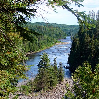
The Kaministiquia River is a river which flows into western Lake Superior at the city of Thunder Bay, Ontario. Kaministiquia is an Ojibwe word meaning "where a stream flows in island" due to two large islands at the mouth of the river. The delta has three branches or outlets, reflected on early North American maps in French as "les trois rivières" : the southernmost is known as the Mission River, the central branch as the McKellar River, and the northernmost branch as the Kaministiquia. Residents of the region commonly refer to the river as the Kam River.

The Mattawa River is a river in central Ontario, Canada. It flows east from Trout Lake east of North Bay and enters the Ottawa River at the town of Mattawa. Counting from the head of Trout Lake, it is 76 kilometres (47 mi) long. The river's name comes from the Algonquin word for "meeting of waterways".

The Missinaibi River is a river in northern Ontario, Canada, which flows northeast from Missinaibi Lake, north of Chapleau, and empties into the Moose River, which drains into James Bay. This river is 755 kilometres (469 mi) in length. It is one of the longest free-flowing and undeveloped rivers in Ontario.
The Winnipeg River is a Canadian river that flows roughly northwest from Lake of the Woods in the province of Ontario to Lake Winnipeg in Manitoba. This river is 235 kilometres (146 mi) long from the Norman Dam in Kenora to its mouth at Lake Winnipeg. Its watershed is 106,500 square kilometres (41,100 sq mi) in area, mainly in Canada. About 29,000 square kilometres (11,000 sq mi) of the watershed is in northern Minnesota, United States.

The Churchill River is a major river in Alberta, Saskatchewan and Manitoba, Canada. From the head of the Churchill Lake it is 1,609 kilometres (1,000 mi) long. It was named after John Churchill, 1st Duke of Marlborough and governor of the Hudson's Bay Company from 1685 to 1691.

Canoe camping, also known as touring, tripping or expedition canoeing, is a combination of canoeing and camping. Canoe campers carry enough with them to travel and camp for several days via a canoe.

The Hayes River is a river in Northern Manitoba, Canada, that flows from Molson Lake to Hudson Bay at York Factory. It was historically an important river in the development of Canada and is now a Canadian Heritage River and the longest naturally flowing river in Manitoba.

Grand Portage National Monument is a United States National Monument located on the north shore of Lake Superior in northeastern Minnesota that preserves a vital center of fur trade activity and Anishinaabeg Ojibwe heritage. The area became one of the British Empire's four main fur trading centers in North America, along with Fort Niagara, Fort Detroit, and Michilimackinac.
The Methye Portage or Portage La Loche in northwestern Saskatchewan was one of the most important portages in the old fur trade route across Canada. The 19 km (12 mi) portage connected the Mackenzie River basin to rivers that ran east to the Atlantic. It was reached by Peter Pond in 1778 and abandoned in 1883 when steamboats began running on the Athabasca River with links to the railroad. It ranks with Grand Portage as one of the two most important and difficult portages used during the fur trade era.
Seton Portage Historic Provincial Park is a historic provincial park located in the community of Seton Portage, British Columbia, Canada. It was established on March 29, 1972 to commemorate the location of the first railway in the province of British Columbia.
The Obabika River Provincial Park is a provincial park in Ontario, Canada, straddling across the boundaries of the Sudbury, Nipissing, and Timiskaming Districts. While it is named after and includes the Obabika River, the bulk of the park extends north of Obabika Lake to the eastern boundary of Lady Evelyn-Smoothwater Provincial Park.

Lady Evelyn-Smoothwater Provincial Park is a remote wilderness park in northeastern Ontario, Canada, north of Lake Temagami. It is one of five provincial parks located in the Temagami area.

The Sturgeon River Provincial Park is a provincial park in northern Ontario, Canada, that protects about 70 kilometres (43 mi) long section of the Sturgeon River and its banks, from Woods Lake to the Sudbury-Nipissing District boundary. It was established in 1989 and expanded in 2005. It protects outstanding water routes that provide recreational canoe camping opportunities. Other activities include hunting and fishing.

This article covers the water based Canadian canoe routes used by early explorers of Canada with special emphasis on the fur trade.
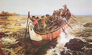
Voyageurs were 18th and 19th century French Canadians who transported furs by canoe at the peak of the North American fur trade. The emblematic meaning of the term applies to places and times where that transportation was over long distances. The voyageurs' strength and endurance was regarded as legendary. They were celebrated in folklore and music. For reasons of promised celebrity status and wealth, this position was coveted.
The Echimamish River is a river bifurcation in Manitoba, Canada. Located 70 kilometres (43 mi) northeast of the northern tip of Lake Winnipeg, it is about 60 kilometres (37 mi) long and runs east–west between the Hayes River and the Nelson River. It flows through nearly flat swampy country and has a barely detectable current. Flowing through peat bogs, the water acquires a dark color, hence the old name of Blackwater Creek. Since it is shallow canoe navigation is helped by beaver ponds. Morse claims that it flows in two directions from a central beaver pond. On the Echimamish is the Painted Stone Portage. This is not the divide between the two river basins, but a short carry around a shallow and rocky section. The only other obstacles are beaver dams.
Kakagi Lake, also known as Crow Lake, is a lake in both Unorganized Kenora District and the township of Sioux Narrows-Nestor Falls, Kenora District, in Northwestern Ontario, Canada. It is just north of the community of Nestor Falls, and right across Ontario Highway 71 from Stevens Bay on Lake of the Woods. It also feeds Lake of the Woods through a series of lakes starting with Cedartree Lake.
Solace Provincial Park is a remote provincial park in Sudbury District, Ontario, Canada. It was established in 1985 and protects a series of lakes that provide backcountry canoeing opportunities. It is characterized by boreal forest, mostly jack pine conifer forest with mixed forest including white birch. The roadless park, with topography and scenery similar to the adjacent Lady Evelyn-Smoothwater Provincial Park, is considered as "one of the most isolated, wild places in Ontario."
