The Bavarian Forest is a wooded, low-mountain region in Bavaria, Germany that is about 100 kilometres long. It runs along the Czech border and is continued on the Czech side by the Bohemian Forest. Most of the Bavarian Forest lies within the province of Lower Bavaria, but the northern part lies within Upper Palatinate. In the south it reaches the border with Upper Austria.
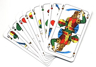
Schafkopf, Schaffkopf or Schafkopfen, also called Bavarian Schafkopf to distinguish it from German Schafkopf, is a late 18th-century German trick-taking card game of the Ace-Ten family, still very popular in Bavaria, where it is their national card game, but also played in other parts of Germany as well as other German-speaking countries like Austria. It is an official cultural asset and important part of the Old Bavarian and Franconian way of life. Schafkopf is a mentally demanding game that is considered "the supreme discipline of Bavarian card games".

The Palatinate Forest, sometimes also called the Palatine Forest, is a low-mountain region in southwestern Germany, located in the Palatinate in the state of Rhineland-Palatinate. The forest is a designated nature park covering 1,771 km2 and its highest elevation is the Kalmit.

Maikammer is a municipality in the Südliche Weinstraße district, in Rhineland-Palatinate, Germany. It is situated on the German Wine Route, approx. 5 km south of Neustadt an der Weinstraße. Maikammer is the seat of the Verbandsgemeinde Maikammer.

Ramberg is a municipality in Südliche Weinstraße district, in Rhineland-Palatinate, western Germany.

The North Palatine Uplands, sometimes incorrectly shortened to Palatine Uplands, is a low mountain range and landscape unit in the German state of Rhineland-Palatinate and belongs mainly to the Palatinate region. It is part of the Saar-Nahe Uplands.

Diemerstein Forest is a part of the Palatine Forest, a mountainous region within the German state of Rhineland-Palatinate. It has an area of about 50 km².

The Blättersberg near Rhodt unter Rietburg in the Rhenish-Palatine county of Südliche Weinstraße is a mountain, 613.2 m above sea level (NHN), in the Palatine Forest in the German state of Rhineland-Palatinate.
The Hohe Stoppelkopf, locally just called the Stoppelkopf, is a 566.2-metre-high hill in the Palatine Forest in the German state of Rhineland-Palatinate. It lies 3 km north of the small town of Lambrecht.

The Eschkopf near Hofstätten in the German state of Rhineland-Palatinate is a major hill, 608.3 m above sea level (NHN) high in the Palatine Forest.

The Hochberg is a 636-metre-high mountain in the central Haardt in the Palatine Forest in Germany. It lies on the territory of the municipality of Sankt Martin (Palatinate) in the county of Südliche Weinstraße in the state of Rhineland-Palatinate. After the Kalmit, the Kesselberg and the Roßberg it is the fourth highest peak in the Palatine Forest.

The Hortenkopf is a hill, 606 metres above sea level (NN), in the German state of Rhineland-Palatinate, which lies in the middle of the Palatine Forest between Hofstätten and Leimen. The Hortenkopf is recognisable from a long way off thanks to the transmission tower that has been erected on its summit.

The Weißenberg in the Palatine Forest is a hill in the municipality of Merzalben. Its height is variously give as 610 m above sea level (NHN) or 607 m above NHN. The higher value has been officially recommended since 2011. That makes the Weißenberg the highest point in the west of the mountain range, ahead of the Eschkopf and Mosisberg. As part of the Palatine Forest-North Vosges Biosphere Reserve it is protected by special conservation measures.

The Taubenkopf is a hill, about 604 metres (1,982 ft) high, in the German state of Rhineland-Palatinate. It is part of the mountain chain of the Haardt in the Palatine Forest and lies in the municipal territory of Diedesfeld in the borough of Neustadt an der Weinstraße.

The Peterskopf, near the Palatine county town of Bad Dürkheim in the German state of Rhineland-Palatinate, is a 487-metre-high hill in the Haardt mountains. On its summit is the Bismarck tower.

German Schafkopf is an old German card game and the forerunner of the popular modern games of Skat, Doppelkopf and Bavarian Schafkopf. Today it is hardly ever played in its original form, but there are a number of regional derivations.
Officers' Schafkopf, or Two-Hand Schafkopf, is a German point-trick, card game for two players which is based on the rules of Schafkopf. The game is a good way to learn the trumps and suits for normal Schafkopf and to understand what cards one is allowed to play.