Schindhübel

Last updated
Schindhübel

Schindhubel-Aussichtsturm.JPG

Observation tower on the Schindhübel
Highest point
Elevation 571 m above  sea level (NN) (1,873 ft)
Coordinates 49°19′23″N7°52′31″E / 49.32306°N 7.87528°E / 49.32306; 7.87528 Coordinates: 49°19′23″N7°52′31″E / 49.32306°N 7.87528°E / 49.32306; 7.87528
Geography
Rhineland-Palatinate relief location map.svg
Red triangle with thick white border.svg
Schindhübel
Parent range Palatine Forest

The Schindhübel is a hill, 571 m above  sea level (NN) , that rises in the middle of the Palatine Forest in Germany, 5 kilometres southwest of Elmstein.

Normalnull

Normalnull or Normal-Null is an outdated official vertical datum used in Germany. Elevations using this reference system were to be marked "Meter über Normal-Null". Normalnull has been replaced by Normalhöhennull.

Germany Federal parliamentary republic in central-western Europe

Germany, officially the Federal Republic of Germany, is a country in Central and Western Europe, lying between the Baltic and North Seas to the north, and the Alps to the south. It borders Denmark to the north, Poland and the Czech Republic to the east, Austria and Switzerland to the south, France to the southwest, and Luxembourg, Belgium and the Netherlands to the west.

Elmstein Place in Rhineland-Palatinate, Germany

Elmstein is an Ortsgemeinde – a municipality belonging to a Verbandsgemeinde, a kind of collective municipality – in the Bad Dürkheim district in Rhineland-Palatinate, Germany.

Contents

Geography

It is part of the central massif of this mountain range and also lies on the Palatine Watershed. This massif stretches roughly from Hochspeyer via Johanniskreuz to the B 10 federal highway near Hauenstein. The region between Johanniskreuz and Hermersbergerhof is rather like a high plateau that is bounded by deeply incised valleys.

Palatine Watershed

The Palatine Watershed forms the main drainage divide in the Palatinate between the Upper Rhine and the Middle Rhine, the two successive sections of the river Rhine that flow through the German state of Rhineland-Palatinate.

Hochspeyer Place in Rhineland-Palatinate, Germany

Hochspeyer is a municipality in the district of Kaiserslautern, in Rhineland-Palatinate, Germany. It is situated in the Palatinate forest, approx. 10 km east of Kaiserslautern.

Johanniskreuz Ortsteil of Trippstadt in Rhineland-Palatinate, Germany

Johanniskreuz is a tiny hamlet in the middle of the Palatine Forest in Germany and belongs to the municipality of Trippstadt in the district of Kaiserslautern in the state of Rhineland-Palatinate.

From the Eschkopf hill, the ridge runs northwest over the Schindhübel to the Bloskülb (570 m above NN) near the Elmstein village of Iggelbach. This ridge separates the upper tributaries of Speyerbach and Helmbach.

Eschkopf German hill

The Eschkopf near Hofstätten in the German state of Rhineland-Palatinate is a major hill, 608.3 m above sea level (NHN) high in the Palatine Forest.

Bloskülb mountain

The Bloskülb is a 570-metre-high hill in the central part of the Palatine Forest of Germany. It lies about three kilometres northwest of the village of Iggelbach. It is located entirely within the territory of the municipality of Elmstein.

Speyerbach river in Germany

The Speyerbach is a left tributary of the Rhine in the Palatinate part of Rhineland-Palatinate. In Speyer, the river split into Gießhübelbach and Woogbach. The Woogbach changes its name to Nonnenbach, then flows into Gießhübelbach shortly before the latter flows into the Rhine.

Viewing tower

On top of the Schindhübel is a 17-metre-high observation tower, which was built in 1975 by an engineer unit from Speyer. From here there are views of the eastern Palatine Forest as far as the Haardt, as well as the striking mountain mass of the Donnersberg to the north and, in good visibility, the great Hornisgrinde mountain in the Northern Black Forest, 83 kilometres away to the south. To the west the view is limited by the nearby Eschkopf.

Haardt mountain range

The Haardt is a range of wooded, sandstone hills in the state of Rhineland Palatinate in southwestern Germany. The range is some 85 kilometres (53 mi) long and lies within the Palatinate Forest (Pfälzerwald). Its highest point is the Kalmit, near Maikammer, which stands 673 metres (2,208 ft) above sea level.

Donnersberg mountain

The Donnersberg is the highest peak of the Palatinate region of Germany. The mountain lies between the towns of Rockenhausen and Kirchheimbolanden, in the Donnersbergkreis district, which is named after the mountain. The highway A63 runs along the southern edge of the Donnersberg. European walking route E8 runs across the mountain.

Hornisgrinde mountain

The Hornisgrinde, 1,164 m (3,820 ft), is the highest mountain in the Northern Black Forest of Germany. The Hornisgrinde lies in northern Ortenaukreis district.

Two kilometres northwest, in the direction of the Bloskülb and Iggelbach, are the wall foundations of a forester's lodge which was allocated to the "Hunters from Electoral Palatinate" (Jäger aus Kurpfalz).

Electoral Palatinate historical territory of the Holy Roman Empire

The County Palatine of the Rhine, later the Electorate of the Palatinate or simply Electoral Palatinate, was a territory in the Holy Roman Empire administered by the Count Palatine of the Rhine. Its rulers served as prince-electors (Kurfürsten) from "time immemorial", were noted as such in a papal letter of 1261, and were confirmed as electors by the Golden Bull of 1356.

Related Research Articles

Bavarian Forest low-mountain range in Bavaria, Germany

The Bavarian Forest is a wooded, low-mountain region in Bavaria, Germany that is about 100 kilometres long. It runs along the Czech border and is continued on the Czech side by the Bohemian Forest. Most of the Bavarian Forest lies within the province of Lower Bavaria, but the northern part lies within Upper Palatinate. In the south it reaches the border with Upper Austria.

Palatinate Forest low mountain range in Germany

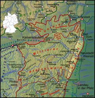
The Palatinate Forest, sometimes also called the Palatine Forest, is a low-mountain region in southwestern Germany, located in the Palatinate in the state of Rhineland-Palatinate. The forest is a designated nature park covering 1,771 km2 and its highest elevation is the Kalmit.

Kalmit highest peak in the Palatinate Forest, Germany

The Kalmit is the highest peak in the Palatinate Forest and the second highest in the Palatinate region of Germany. It is 672.6 m above sea level (NHN) and located 5.5 kilometres (3.4 mi) south of the town of Neustadt an der Weinstraße.

Heber (hills) mountain range

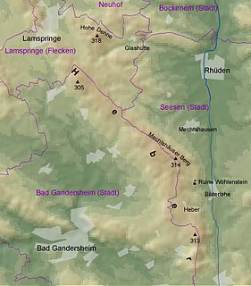
The Heber is a hogback ridge, relatively small in area and up to 313.5 metres high, in the Lower Saxon Hills within the districts of Goslar, Northeim and Hildesheim in the German state of Lower Saxony.

Frankenweide

The Frankenweide is a hill region in the German state of Rhineland-Palatinate. It forms the central part of the Palatine Forest in the Palatinate region.

Brogberg mountain

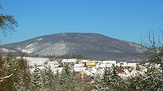
The Brogberg is a hill, 567 metres high, in the Palatine Forest in Germany. It is located west of Iggelbach, a village in the municipality of Elmstein. Northeast of the hill rises the Iggelbach stream, a left tributary of the Helmbach. The Brogberg lies entirely within the territory of the municipality of Elmstein.

Hohe Loog (Haardt) mountain

The Hohe Loog, is a mountain, 619 m above sea level (NN), in the Haardt, the eastern rim of the Palatine Forest in Germany. The mountain lies within the borough of Neustadt an der Weinstraße in the southern part of the state of Rhineland-Palatinate.

Hortenkopf mountain

The Hortenkopf is a hill, 606 metres above sea level (NN), in the German state of Rhineland-Palatinate, which lies in the middle of the Palatine Forest between Hofstätten and Leimen. The Hortenkopf is recognisable from a long way off thanks to the transmission tower that has been erected on its summit.

Mosisberg mountain

The Mosisberg near Hofstätten in the German state of Rhineland-Palatinate is a hill, 608.7 m above sea level (NHN), in the central Palatine Forest. It has two domes, the eastern one is the summit and is called Langer Kopf and the western high point is the Preußenstein.

Weißenberg (Frankenweide)

The Weißenberg in the Palatine Forest is a hill in the municipality of Merzalben. Its height is variously give as 610 m above sea level (NHN) or 607 m above NHN. The higher value has been officially recommended since 2011. That makes the Weißenberg the highest point in the west of the mountain range, ahead of the Eschkopf and Mosisberg. As part of the Palatine Forest-North Vosges Biosphere Reserve it is protected by special conservation measures.

Walking routes in the Palatine Forest

Walking routes in the Palatine Forest fall into two categories. The first are longer walking routes, most of which are maintained by the Palatine Forest Club, or PWV, and which are linked to the national and international network of long distance paths. The second category are those local circular walks and themed walking routes, some of which are of wider regional importance, and which are maintained by municipal authorities. The Palatine Forest, as part of the Palatine Forest-North Vosges Biosphere Reserve, is an important conservation area. As a result, the Palatine Forest, the bunter sandstone landscape of the Palatine Forest Nature Park, the castles in the Dahner Felsenland and the cross-border paths into Alsace and the Vosges make the region particularly popular with ramblers and walkers.

Palatine Ways of St. James

The Palatine Ways of St. James are those sections of the Way of St. James in the Palatinate region of Germany and part of the historic pilgrimage route to the northwest Spanish town of Santiago de Compostela. It was there that, according to Christian tradition, the Apostle Saint James the Greater was buried.

Elmstein valley valley

The Elmstein valley runs through the central Palatine Forest region between the villages of Frankeneck and Johanniskreuz in the German state of Rhineland-Palatinate. The Speyerbach stream, a left tributary of the Rhine, flows through the valley.

Großer Farmdenkopf mountain

At 869 m above sea level (NN), the Großer Farmdenkopf is the highest peak in the Thuringian Highland. It is situated in the county of Sonneberg in the German state of Thuringia.

References