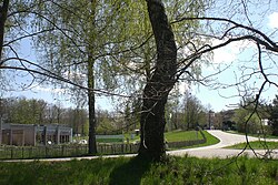
Johanniskreuz lies in a saddle at about 470 metres (1,540ft), north of the midpoint of the central massif of the Palatine Forest, the Frankenweide, whose surrounding peaks are only a little higher. The Frankenweide, across which the Palatine Watershed runs, is bounded to the west, north and east in the area of Johanniskreuz by the valleys of streams that rise near the hamlet. Immediately west of Johanniskreuz is the source of the Moosalb, a tributary of the Schwarzbach, which itself rises one kilometre southwest of Johanniskreuz. The waters of these streams initially flow westwards through the Blies and Saar rivers into the river Moselle and then on to the Rhine. A little to the east of Johanniskreuz is the source of another Schwarzbach, this time the left-hand headstream of the Speyerbach; which flows eastwards, directly to the Rhine.
The municipal centre of Trippstadt is about 4.5 kilometres away as the crow flies. The municipal boundary between Trippstadt and Elmstein, as well as the county boundary between Kaiserslautern and Bad Dürkheim, runs immediately east of the hamlet.
Climate
The annual precipitation in Johanniskreuz is 1,005mm and thus lies in the upper quadrant of values within Germany. The driest month is September; the most precipitation falls in December, i.e. 1.6-times as much as in September.
History
Name
In the foreground is a so-called Ritterstein. Behind: the stone crosses
The name of the parish may go back to Johannes von Wilenstein. He was a liege lord (German: Lehnsherr) at the nearby castle and, in 1269, he had his coat of arms inscribed as a boundary marker – apparently illegally – on an existing wayside cross (Flurkreuz) which belonged to the lords of Hohenecken. Lord John's Cross (Herrn Johanns Creutz) is first mentioned in the records in 1551. Only remnants of the oldest cross have survived; two crosses of more recent date were placed beside it. Since the district reform of 1972 Johanniskreuz has belonged entirely to the municipality of Trippstadt; before that several of the houses, based on the historic boundaries, were in the parish of Wilgartswiesen.
Palatine Forest
At a meeting of Palatine forest officials in Johanniskreuz in August 1843 the name Pfälzerwald ("Palatine Forest") was given to the northern part of the Vosges mountains. In a way Johanniskreuz is thus the "birthplace" of the Palatine Forest which, until the early 20th century was counted as part of the Vosges or Wasgenwald in most travel literature.
Roman Catholic Convention
Advertisement for the Catholic Convention at Johanniskreuz in 1931 with Anton Fooß as the keynote speaker
Johanniskreuz is part of the Roman Catholic parish of Trippstadt. In 1908, after the theology graduate, Anton Fooß, had taken over the benefice there in 1906, he initiated the first Speyer Diocesan Catholic Convention (Speyerer Diözesan-Katholikentag) in Johanniskreuz. This Catholic Convention was a firm tradition in the Diocese of Speyer and took place annually at the venue selected by Fooß in Johanniskreuz until 2007.
Many well known bishops, churchmen, politicians and otherwise notable Roman Catholics since 1908 went to the annual convention in Johanniskreuz as guests, celebrants, preachers or speakers. On 19July 1931, Anton Fooß, now living in Würzburg as an initiator, joined the event again as its keynote speaker. He gave a speech on the 40th anniversary of the death of Ludwig Windthorst entitled "Windthorst and Our Time". It was to be the last of these conventions before the Second World War. In 1932 it was cancelled because on the same day Reich Chancellor Heinrich Brüning was speaking at a major event of the Centre Party in Ludwigshafen. From 1933, during the Nazi era, these diocesan conventions could no longer take place. Only after the Second World War was the tradition revived.
In 2007 it came to light that most of the old deciduous and pine trees at the woodland venue were in danger of falling. Because no funding is available to carry our safety work, the Roman Catholic Convention is no longer held in Johanniskreuz.
Economy and infrastructure
Transport
Summertime biker's gathering in Johanniskreuz
Johanniskreuz has always been a central communication hub in the Palatine Forest. Whilst the most important historic link from Speyer to Metz ran from east to west and the area around Johanniskreuz was also part of the northern route of the Palatine St. James' Ways, today the main transport axis is the B48 federal highway from Annweiler to Hochspeyer which runs from north to south. From the Queich valley to Hochspeyer, Johanniskreuz is the only settlement on this very route, which is very winding especially in the north. Also important from a transport perspective is the equally winding state road through the Elmstein Valley towards Neustadt an der Weinstraße. Other road links in a western direction through the Karlstal to Trippstadt and southwest – Heltersberg, Waldfischbach-Burgalben – in places follow paths that were used in the Middle Ages.
As the hub of several scenic routes Johanniskreuz has become a meeting place for motorcyclists. However, the road through the Elmsteiner Tal is closed to motorcycles at weekends during the summer months due to the high number of accidents.
Since the first attempts at developing tourism in the Palatine Forest in the 19th century, Johanniskreuz has been a top destination for visitors to the region. Spa houses (Kurhäuser) were established early on that, today, function as hotels. In 2004 the House of Sustainability (Haus der Nachhaltigkeit) opened, with permanent exhibitions about sustainable economics and future energy concepts as its main attraction. The latest tourist facility is the Palatine Forest Mountain Bike Park (Mountainbikepark Pfälzerwald), for which 5 routes, together over 300kilometres long, have been marked out. Johanniskreuz is also the intersection of all footpaths marked with a cross by the Palatine Forest Club.
Literature
Hubert Zintl (2006), Johanniskreuz. Im Herzen des Pfälzerwaldes: Eine Forst- und Waldgeschichte (in German), Mainz: Ministerium für Umwelt, Forsten und Verbraucherschutz Rheinland-Pfalz/Landesforsten Rheinland-Pfalz, ISBN3-00-019005-8
External links
Wikimedia Commons has media related to Johanniskreuz.
The Palatinate is a historical region of Germany (Deutschland). In the Middle Ages it was known as the Rhenish Palatinate (Rheinpfalz) and Lower Palatinate (Unterpfalz), which strictly speaking designated only the western part of the Electorate of the Palatinate, as opposed to the Upper Palatinate (Oberpfalz). It occupies roughly the southernmost quarter of the German federal state of Rhineland-Palatinate (Rheinland-Pfalz), covering an area of 2,105 square miles (5,450 km2) with about 1.4 million inhabitants. Its residents are known as Palatines (Pfälzer).
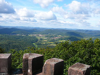
The Palatinate Forest, sometimes also called the Palatine Forest, is a low-mountain region in southwestern Germany, located in the Palatinate in the state of Rhineland-Palatinate. The forest is a designated nature park covering 1,771 km2 and its highest elevation is the Kalmit.
Hochspeyer is a municipality in the district of Kaiserslautern, in Rhineland-Palatinate, Germany. It is situated in the Palatinate forest, approx. 10 km east of Kaiserslautern.
Elmstein is an Ortsgemeinde – a municipality belonging to a Verbandsgemeinde, a kind of collective municipality – in the Bad Dürkheim district in Rhineland-Palatinate, Germany.
The Kalmit is the highest peak in the Palatinate Forest and the second highest in the Palatinate region of Germany. It is 672.6 m above sea level (NHN) and located 5.5 kilometres (3.4 mi) south of the town of Neustadt an der Weinstraße.
The Palatine Forest Mountain Bike Park in the Palatinate Forest is a mountain bike trail network in Germany, in the centre of the biosphere reserve of the Palatinate Forest-North Vosges. The network was opened in April 2005.
The Palatinate Forest Nature Park lies in the south of Rhineland-Palatinate in Germany and borders on France. The nature park covers an area of 177,100 hectares (684 sq mi) and some 76% of its area is under the woods of the Palatinate Forest, the largest contiguous forest region in Germany. Together with parts of northern Alsace and Lorraine, it forms the Palatinate Forest-North Vosges Biosphere Reserve and has an impressive Bunter sandstone landscape.
The Palatine Watershed forms the main drainage divide in the Palatinate between the Upper Rhine and the Middle Rhine, the two successive sections of the river Rhine that flow through the German state of Rhineland-Palatinate.
The Wasgau is a Franco-German hill range in the German state of Rhineland-Palatinate and the French departments of Bas-Rhin and Moselle. It is formed from the southern part of the Palatine Forest and the northern part of the Vosges mountains, and extends from the River Queich in the north over the French border to the Col de Saverne in the south.
The Frankenweide is a hill region in the German state of Rhineland-Palatinate. It forms the central part of the Palatine Forest in the Palatinate region.
The Eschkopf near Hofstätten in the German state of Rhineland-Palatinate is a major hill, 608.3 m above sea level (NHN) high in the Palatine Forest.
The Hortenkopf is a hill, 606 metres above sea level (NN), in the German state of Rhineland-Palatinate, which lies in the middle of the Palatine Forest between Hofstätten and Leimen. The Hortenkopf is recognisable from a long way off thanks to the transmission tower that has been erected on its summit.
The Schindhübel is a hill, 571 m above sea level (NN), that rises in the middle of the Palatine Forest in Germany, 5 kilometres southwest of Elmstein.
The Weißenberg in the Palatine Forest is a hill in the municipality of Merzalben. Its height is variously give as 610 m above sea level (NHN) or 607 m above NHN. The higher value has been officially recommended since 2011. That makes the Weißenberg the highest point in the west of the mountain range, ahead of the Eschkopf and Mosisberg. As part of the Palatine Forest-North Vosges Biosphere Reserve it is protected by special conservation measures.
Walking routes in the Palatine Forest fall into two categories. The first are longer walking routes, most of which are maintained by the Palatine Forest Club, or PWV, and which are linked to the national and international network of long distance paths. The second category are those local circular walks and themed walking routes, some of which are of wider regional importance, and which are maintained by municipal authorities. The Palatine Forest, as part of the Palatine Forest-North Vosges Biosphere Reserve, is an important conservation area. As a result, the Palatine Forest, the bunter sandstone landscape of the Palatine Forest Nature Park, the castles in the Dahner Felsenland and the cross-border paths into Alsace and the Vosges make the region particularly popular with ramblers and walkers.
The Palatine Ways of St. James are those sections of the Way of St. James in the Palatinate region of Germany and part of the historic pilgrimage route to the northwest Spanish town of Santiago de Compostela. It was there that, according to Christian tradition, the Apostle Saint James the Greater was buried.
The Elmstein valley runs through the central Palatine Forest region between the villages of Frankeneck and Johanniskreuz in the German state of Rhineland-Palatinate. The Speyerbach stream, a left tributary of the Rhine, flows through the valley.
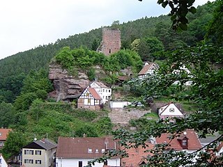
The ruins of Breitenstein Castle stand on a crag, 220 metres (720 ft) high, on the northern side of the Speyerbach valley in the Palatine Forest in Germany. The castles is 4 kilometres (2.5 mi) east of the village of Elmstein in the county of Bad Dürkheim in the state of Rhineland-Palatinate.
The House of Sustainability is a project run by the Rhineland-Palatinate Ministry for the Environment and Consumer Protection. The house is in the hamlet of Johanniskreuz in the German municipality of Trippstadt in the middle of the Palatinate Forest within the Palatine Forest-North Vosges Biosphere Reserve. The purpose of the house is to illustrate the concept of sustainability, especially to its adult visitors. The House of Sustainability is part of the Rhineland-Palatinate Efficiency Network or EffNet, which aims to deliver better resource efficiency.
This page is based on this Wikipedia article Text is available under the CC BY-SA 4.0 license; additional terms may apply. Images, videos and audio are available under their respective licenses.