
The Frankenweide is a hill region in the German state of Rhineland-Palatinate. It forms the central part of the Palatine Forest in the Palatinate region.
The Frankenweide is a hill region in the German state of Rhineland-Palatinate. It forms the central part of the Palatine Forest in the Palatinate region.

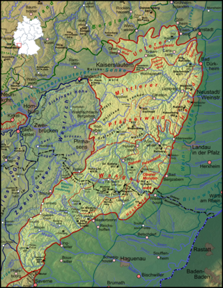
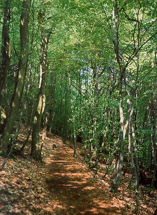
The Frankenweide is a single forest that, today, covers an area of a good 200 square kilometres (77 sq mi). Much of it is a plateau at an elevation of about 380–450 m above sea level (NN) , which climbs steadily from north to south. Individual hill summits rise prominently from the plateau, which is framed by deeply incised valleys. In the south the Frankenweide is bounded by the valley of the Queich, in the east by the Wellbach stream and its northern projection. There it is adjoined by imperial forest, the Rhineland-Palatinate Reichswald of Kaiserslautern. In the northwest the Moosalb stream forms the border, and in the southwest, it is bounded by Gräfenstein Land. From north to south the region is divided into Lower Frankenweide (Untere Frankenweide) with its municipality of Waldleiningen, Middle Frankenweide (Mittlere Frankenweide) and Eschkopf, and Upper Frankenweide (Obere Frankenweide) around the hamlet of Hermersbergerhof which is part of the municipality of Wilgartswiesen. [1]
The highest points of the area lie in the Middle and Upper Frankenweide, along which the watershed between the Upper Rhine and the Middle Rhine (or Moselle) runs. These high points are the Eschkopf and the Mosisberg, each 609 metres (1,998 ft) high, the Hortenkopf at 606 metres (1,988 ft) and the Weißenberg at (610 metres (2,000 ft). In a high hollow southeast of the Mosisberg summit there was once a raised bog, the Mosisbruch, which was fed by a two-kilometre-long (1.2 mi) stream that emptied into the upper Wellbach shortly thereafter. At the Hortenkopf the watershed turns towards the southwest, heading in the direction of Gräfenstein Castle, hence the Weißenberg is no longer on the watershed. [2]

The name Frankenweide ("Frankish pasture") emerged, as it suggests, in the Frankish period, at the latest in the 6th century. At that time the woods were completely unsettled and were partly used for the grazing of animals, mainly domestic pigs and goats. When the presumably Frankish counts of Leiningen were first mentioned in the 12th century, they were responsible for the management of the Frankenweide. In the 13th century, the knight, John of Wilenstein, after whom the hamlet of Johanniskreuz is named, was the instigator of several feuds.
Although the House of Wittelsbach from Palatinate-Zweibrücken also had estates and titles in the Frankenweide for a time, the Leiningen head office (Oberamt) at the castle of Falkenburg near Wilgartswiesen remained administratively responsible until France conquered the Electoral Palatine territories west of the Rhine after the French Revolution in the 1790s and annexed them in 1801. Shortly beforehand, in 1785, the Frankenweide as a whole had transferred formally to the County of Leiningen. [2] [3]
During its history, the Frankenweide repeatedly lost land, in total about 100 km². In the east in the 12th century the Elmstein Forest around the upper Speyerbach valley was partitioned off. In 1304 King Albert of Habsburg granted the large area in the southeast - which lay between the valleys of the Wellbach and Eußerbach from the forester's lodge, Forsthaus Taubensuhl, in the north to the Queich valley in the south - to the imperial city of Annweiler; today the area is called the Annweiler Municipal Forest (Annweiler Bürgerwald). In 1602 the Esthal Forest in the northeast was given to the fief of Erfenstein.
The present region of Frankenweide belongs mainly to the counties of Kaiserslautern und Südwestpfalz.

When, in the 9th century, the Palatine, which still belonged to Middle Francia, opened more and more monasteries, the edge of the Palatinate Forest gradually became increasingly settled. This did not affect the Frankenweide, however, which lay in the heart of the mountains. For a long time the only outpost of civilization was Hermersbergerhof founded by Hornbach Abbey and mentioned as early as 828 A.D. Over the centuries, foresters' lodges and charcoal burners' cottages were built here and there, and the foresters' base of Hofstätten was built by the Leiningen authorities and mentioned first in 1379. Excavations at Mosisbruch near the Wellbach valley showed that a settlement must have existed here too from the 11th to the 14th century. But the authorities in Wilgartswiesen, whose territory today include large parts of the Frankenweide, was too far away to be able to successfully plan and development the area. As a result of the Thirty Years' War even the few populated places were abandoned in the first half of the 17th century and it was not until around 1785 that the foresters' village of Waldleiningen was laid out at the instigation of Prince Carl Frederick William of Leiningen-Hardenburg, which remained the only independent municipality in the Frankenweide. Today less than a thousand people live in this remote region.
With its central communication hub at Johanniskreuz, Frankenweide was a transit route between the Upper Rhine Valley and what is now Lorraine from the earliest times. At that time, when roads followed the ridges wherever possible, ways branched off the main route towards the monasteries of Wissembourg Abbey and Hornbach as well as the Imperial Palace at Kaiserslautern. The northern route of the Palatine Way of St. James crossed the northern part of the Frankenweide.
Today footpaths and roads often follow the courses of the old ways. [4] However, the Frankenweide is no longer mainly approached in an east-west direction, but on the winding B 48, which climbs up from the B 10 federal highway to the south through the Wellbach valley to Johanniskreuz, the only settlement on the whole route, and then runs on to join the B 37 near Hochspeyer to the north.

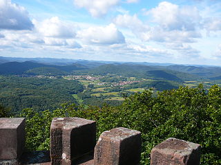
The plateau with its extensive forests is a destination for hikers. All Palatinate Forest Club long distance paths marked with a cross and that radiate across the entire Palatinate, meet at Johanniskreuz in the heart of the Frankenweide. [4] There are viewing towers on the Weißenberg and the Eschkopf. For mountain bikers there are courses at the Palatine Forest Mountain Bike Park and in the neighbouring region of Holzland. [5]

Johanniskreuz, with its House of Sustainability and a few other houses, mainly hotels and restaurants, is the touristic centre of the Frankenweide. The Palatine Catholics Day and woodland services take place here and, on Sundays, especially in good weather, hundreds of bikers meet here. On the Hermersbergerhof, whose six-kilometre-long approach road between Wilgartswiesen and Hauenstein branches off the B 10 abzweigt and then continues as a narrow lane for ten kilometres to the Landstraße from Leimen to Johanniskreuz, is used for winter sports in good snow conditions; but due to the increasingly mild winters the skilift was dismantled in the 1990s. A toboggan run still exists, however.
One tourist attraction is the landmark built in the 1860s on the 459-metre-high Roßrück near Waldleiningen by the Kingdom of Bavaria which became known locally as the Palatine World Axis (Pälzer Weltachs). It became the subject of local poet, Paul Münch, in his well-known Palatine poem. In 1964 a passage from his poem was inscribed on a nearby rock. [6]
The Palatinate Forest, sometimes also called the Palatine Forest, is a low-mountain region in southwestern Germany, located in the Palatinate in the state of Rhineland-Palatinate. The forest is a designated nature park covering 1,771 km2 and its highest elevation is the Kalmit.

Elmstein is an Ortsgemeinde – a municipality belonging to a Verbandsgemeinde, a kind of collective municipality – in the Bad Dürkheim district in Rhineland-Palatinate, Germany.

Merzalben is a municipality in Südwestpfalz district, in Rhineland-Palatinate, western Germany, deriving its name from the Merzalbe, also known as the Merzalb, that flows through the village. Along with 5 other Ortsgemeinden Merzalben belongs to the Verbandsgemeinde Rodalben in Südwestpfalz, wherein it is the largest in terms of physical area, but the smallest in terms of population. The municipality contains several distinct natural and cultural landmarks, with the earliest known records dating back to 1237. It was also considered a state-approved tourist resort before the title was dropped in Rhineland Palatinate in 2016 and all communities awarded the designation were barred from its use in 2020.

The Queich is a tributary of the Rhine, which rises in the southern part of the Palatinate Forest, and flows through the Upper Rhine valley to its confluence with the Rhine in Germersheim. It is 52 kilometres (32 mi) long and is one of the four major drainage systems of the Palatinate Forest along with the Speyerbach, Lauter and Schwarzbach. The Queich flows through the towns Hauenstein, Annweiler am Trifels, Siebeldingen, Landau, Offenbach an der Queich and Germersheim.

The Landau–Rohrbach railway is a major line running from Landau in the German state of Rhineland-Palatinate to Rohrbach in the Saarland. The main section between Landau and Zweibrücken was opened on 25 November 1875 after the first sections had already been opened between 1857 and 1867.

The Palatine Watershed forms the main drainage divide in the Palatinate between the Upper Rhine and the Middle Rhine, the two successive sections of the river Rhine that flow through the German state of Rhineland-Palatinate.
The Wasgau is a Franco-German hill range in the German state of Rhineland-Palatinate and the French departments of Bas-Rhin and Moselle. It is formed from the southern part of the Palatine Forest and the northern part of the Vosges mountains, and extends from the River Queich in the north over the French border to the Col de Saverne in the south.

The Rehberg is a prominent hill, 576.8 m above sea level (NHN), in the German state of Rhineland-Palatinate. After the Grand Wintersberg (ca. 581 m) in French North Alsace, the Rehberg is the second highest hill in the Wasgau, the Franco-German region that forms the southern part of the Palatine Forest and runs from the valley of the River Queich to the Col de Saverne. The Rehberg is also the highest hill on German soil in the Wasgau. As part of the Palatine Forest-North Vosges Biosphere Reserve it has been placed under special protection measures.

The Leininger Sporn is a highly prominent ridge in the northeast of the Palatinate Forest in western Germany, mainly composed of the rock formations of the Middle and Upper Bunter. It forms the western edge of Upper Rhine Plain between Grünstadt in the north and Leistadt, a village in the county of Bad Dürkheim, in the southeast. In the natural region system of the German Central Uplands it is considered one of the four sub-units of the Middle Palatinate Forest.

The Eschkopf near Hofstätten in the German state of Rhineland-Palatinate is a major hill, 608.3 m above sea level (NHN) high in the Palatine Forest.

The Hortenkopf is a hill, 606 metres above sea level (NN), in the German state of Rhineland-Palatinate, which lies in the middle of the Palatine Forest between Hofstätten and Leimen. The Hortenkopf is recognisable from a long way off thanks to the transmission tower that has been erected on its summit.

The Weißenberg in the Palatine Forest is a hill in the municipality of Merzalben. Its height is variously give as 610 m above sea level (NHN) or 607 m above NHN. The higher value has been officially recommended since 2011. That makes the Weißenberg the highest point in the west of the mountain range, ahead of the Eschkopf and Mosisberg. As part of the Palatine Forest-North Vosges Biosphere Reserve it is protected by special conservation measures.
Walking routes in the Palatine Forest fall into two categories. The first are longer walking routes, most of which are maintained by the Palatine Forest Club, or PWV, and which are linked to the national and international network of long distance paths. The second category are those local circular walks and themed walking routes, some of which are of wider regional importance, and which are maintained by municipal authorities. The Palatine Forest, as part of the Palatine Forest-North Vosges Biosphere Reserve, is an important conservation area. As a result, the Palatine Forest, the bunter sandstone landscape of the Palatine Forest Nature Park, the castles in the Dahner Felsenland and the cross-border paths into Alsace and the Vosges make the region particularly popular with ramblers and walkers.

Johanniskreuz is a tiny hamlet in the middle of the Palatine Forest in Germany and belongs to the municipality of Trippstadt in the district of Kaiserslautern in the state of Rhineland-Palatinate.

Guttenberg Castle is a ruined rock castle near the French border in the German part of the Wasgau, which in turn is part of the Palatine Forest in the state of Rhineland-Palatinate.

The Westrich Plateau, also Zweibrücken Westrich or Southwest Palatine Plateau, is a landscape in the German state of Rhineland-Palatinate, with small areas also in the Saarland (Saarpfalz-Kreis). Its heart is in the southwest of the Palatinate region and it is part of the historic region of Westrich.

Lindelbrunn Castle is the medieval ruin of a rock castle near the village of Vorderweidenthal in the county of Südliche Weinstraße in the German state of Rhineland-Palatinate.

The Merzalbe, also called the Merzalb, is a stream, over 12 km (7.5 mi) long, in the Western Palatinate in the German state of Rhineland-Palatinate. It is an orographically right tributary of the Rodalb. In its upper reaches it is also called Mühlgraben.
Annweiler am Trifels station is the main station in the town of Annweiler am Trifels in the German state of Rhineland-Palatinate. Deutsche Bahn classifies it as a category 5 station and it has three platform tracks. The station is located in the network of the Verkehrsverbund Rhein-Neckar and belongs to fare zones 181 and 191. Since 2002, Annweiler has also been part of the area served by the Karlsruher Verkehrsverbund using tickets at a transitional rate. Annweiler was always the most important station between Landau (Pfalz) Hbf and Pirmasens Nord and it used to be served by long-distance services.