Luitpold Tower

Last updated
The Luitpold Tower near Hermersbergerhof Luitpoldturm.jpg
The Luitpold Tower near Hermersbergerhof

The Luitpold Tower (German : Luitpoldturm or Luitpoldsturm) was erected in 1909 on the summit of one of the highest hills in the Palatine Forest, the 610-metre-high Weißenberg [1] as an observation tower. It is made of bunter sandstone.

German language West Germanic language

German is a West Germanic language that is mainly spoken in Central Europe. It is the most widely spoken and official or co-official language in Germany, Austria, Switzerland, South Tyrol (Italy), the German-speaking Community of Belgium, and Liechtenstein. It is also one of the three official languages of Luxembourg and a co-official language in the Opole Voivodeship in Poland. The languages which are most similar to German are the other members of the West Germanic language branch: Afrikaans, Dutch, English, the Frisian languages, Low German/Low Saxon, Luxembourgish, and Yiddish. There are also strong similarities in vocabulary with Danish, Norwegian and Swedish, although those belong to the North Germanic group. German is the second most widely spoken Germanic language, after English.

Observation tower structure used to view events from a long distance

An observation tower is a structure used to view events from a long distance and to create a full 360 degree range of vision to conduct the long distance observations. They are usually at least 20 metres (66 ft) tall and made from stone, iron, and wood. Many modern towers are also used as TV towers, restaurants, or churches. The towers first appeared in Germany at the end of the 18th century, and their numbers steadily increased, especially after the invention of the lift.

Contents

History and construction

Tablet with dates and construction history of the Luitpold Tower Gedenktafel zur Baugeschichte des Luitpoldturms.JPG
Tablet with dates and construction history of the Luitpold Tower

The idea of building a tower was conceived on 29 May 1895 at the general assembly of the Gräfenstein Conservation Society (Gräfensteiner Verschönerungsverein), a group that forestry assessor August Zwissler from Leimen had founded in 1893. It was decided to build a viewing tower on the Weißenberg costing an estimated 8,000 to 10,000 gold marks. The necessary funding would be raised by society member Martin Jäger, a well known local poet who went under the pseudonym, Fritz Claus. Thanks to his support for the tower he was able to win the Palatine Forest Club, founded in 1902 in Ludwigshafen, to his cause. The leadership of the PWV took over the coordination of the project, had the plans produced by architect Ludwig Ullmann and gathered the necessary funding, predominantly from membership subscriptions. Its name was proposed by Karl Albrecht von Ritter, the chairman of the PWV at the time; it was named after Prince Luitpold of Bavaria. [2] In 1908 construction on the tower began and it was inaugurated on 26 September 1909. [3] The costs came to around 23,000 gold marks, which corresponds to a sum of about €250,000 in 2000. [4] The payment of this amount was concluded in 1911 by the Palatine Forest Club. [5]

German gold mark german currency from 1871-1914

The Goldmark was the currency used in the German Empire from 1873 to 1914. The Papiermark refers to the German currency from 4 August 1914 when the link between the Mark and gold was abandoned.

Palatine Forest Club organization

The Palatine Forest Club is a hiking club in the former Bavarian Palatinate, i.e. the southern part of the German state of Rhineland-Palatinate and the Saarland county of Saarpfalz-Kreis. In 2011 it had 221 local branches with around 27,000 members.

Luitpold, Prince Regent of Bavaria Ruler of Bavaria

Luitpold, Prince Regent of Bavaria, was the de facto ruler of Bavaria from 1886 to 1912, due to the incapacity of his nephews, King Ludwig II for three days and King Otto for 26 years.

Design

The tower seen from the south Luitpoldturm auf dem Weissenberg.JPG
The tower seen from the south

The Luitpold Tower is a rectangular structure built of hewn sandstone blocks and comprises a perron, the actual observation tower itself and an attached building annexe The tower is 34.6 metres high, and the viewing platform is 28.5 metres above ground level. From platform level there is a further, small staircase tower with a door and slate roof.

Sandstone A clastic sedimentary rock composed mostly of sand-sized particles

Sandstone is a clastic sedimentary rock composed mainly of sand-sized mineral particles or rock fragments.

Perron (staircase) outdoor stairway

A perron in architecture generally refers to an external stairway to a building. Curl notes three more-specific usages: the platform-landing reached by symmetrical flights of steps leading to the piano nobile of a building; the steps themselves; or the platform base of edifices like a market cross.

The annexe Luitpoldturm Anbau.JPG
The annexe

After climbing the perron, the visitor enters a staircase tower, well-lit by multiple window openings. There are 164 steps to the observation deck. Halfway up, there is a small oriel window with a bench that can be used to rest. The upper portion of the tower is occupied by a spacious room with a relatively narrow, metallic spiral staircase in the centre, leading to the top. The visitor leaves the staircase turret through a metal door and finally enters the viewing platform, which is surrounded by a sandstone balustrade, approximately waist high, with four observation niches. In 2002, 12 tablets were mounted on this parapet at regular intervals, which point out places of interest that may be seen from the tower, both close to and in the far distance, together with distance information.

Staircase tower

A staircase tower or stair tower is a tower-like wing of a building with a circular or polygonal plan that contains a stairwell, usually a helical staircase.

Observation deck

An observation deck, observation platform or viewing platform is an elevated sightseeing platform usually situated upon a tall architectural structure such as a skyscraper or observation tower. Observation decks are sometimes enclosed from weather, and a few may include coin-operated telescopes for viewing distant features.

Oriel window type of bay window

An oriel window is a form of bay window which protrudes from the main wall of a building but does not reach to the ground. Supported by corbels, brackets, or similar, an oriel window is most commonly found projecting from an upper floor but is also sometimes used on the ground floor.

Rest room in the annexe of the Luitpold Tower Aufenthaltsraum im Anbau des Luitpoldturms.JPG
Rest room in the annexe of the Luitpold Tower

At the foot of the tower is an annexe, intended as a resting place and also as a refuge in case of inclement weather. It contains a stone table and benches, a fireplace and a plaque on which essential data about the tower and its architectural history are documented.

Renovation and conservation

The building has been protected since 1993 and was thoroughly renovated in 2000 and 2001. This entailed improving the structural geometry of the tower and adding a concrete ceiling to the viewing platform. There was also no way round a modification to the iron spiral staircase and a renewal of the roof. The overall cost came to €230,000, almost the same amount originally needed for the construction of the tower. Upon completion of these renovations, the tower was opened to the public again in a ceremony on 28 August 2001. [6]

Structural analysis is the determination of the effects of loads on physical structures and their components. Structures subject to this type of analysis include all that must withstand loads, such as buildings, bridges, vehicles, furniture, attire, soil strata, prostheses and biological tissue. Structural analysis employs the fields of applied mechanics, materials science and applied mathematics to compute a structure's deformations, internal forces, stresses, support reactions, accelerations, and stability. The results of the analysis are used to verify a structure's fitness for use, often precluding physical tests. Structural analysis is thus a key part of the engineering design of structures.

Reinforced concrete composite building material

Reinforced concrete (RC) (also called reinforced cement concrete or RCC) is a composite material in which concrete's relatively low tensile strength and ductility are counteracted by the inclusion of reinforcement having higher tensile strength or ductility. The reinforcement is usually, though not necessarily, steel reinforcing bars (rebar) and is usually embedded passively in the concrete before the concrete sets. Reinforcing schemes are generally designed to resist tensile stresses in particular regions of the concrete that might cause unacceptable cracking and/or structural failure. Modern reinforced concrete can contain varied reinforcing materials made of steel, polymers or alternate composite material in conjunction with rebar or not. Reinforced concrete may also be permanently stressed, so as to improve the behaviour of the final structure under working loads. In the United States, the most common methods of doing this are known as pre-tensioning and post-tensioning.

To support the longer term maintenance of the tower, the Luitpold Tower Club (Luitpoldturmverein) was set up in 2007. Its aim is to "conserve, and where possible improve, the structural state of the tower ... to ensure free access to the tower at any time as well an unobstructed panoramic view for all ... and to keep the public aware of the tower and the extensive views that can be experienced." [7]

Location and views

View from the Luitpold Tower looking south Blick vom Weissenberg nach Suden.JPG
View from the Luitpold Tower looking south

The tower stands on the territory of the municipality of Merzalben in the middle of the Palatine Forest at the highest point of the Weißenberg (610 m above sea level (NN)). The tower is 1.4 kilometres from Hermersbergerhof and may be reached on foot in 10 to 20 minutes. In good weather 457 named places can be identified: in the Palatinate, in the state of Baden-Württemberg, in French Alsace and the Saarland, [8] and the viewing platform has 12 direction tables that enable easy orientation. In good conditions, for example, the following may be seen: the Donnersberg (highest peak in the Palatinate region, 42 km distant, visibility ca. 42%), the Kalmit (highest mountain in the Palatine Forest, 20 km, visibility ca. 82%,), the Donon (highest mountain of the northern Vosges, 96 km, visibility ca. 8%) and the Hornisgrinde (highest mountain in the northern Black Forest, 77 km, visibility ca. 14%). [9]

Related Research Articles

Palatinate Forest low mountain range in Germany

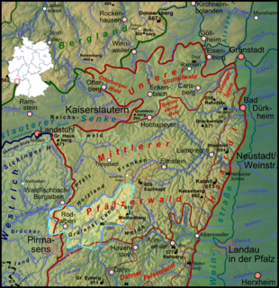
The Palatinate Forest, sometimes also called the Palatine Forest, is a low-mountain region in southwestern Germany, located in the Palatinate in the state of Rhineland-Palatinate. The forest is a designated nature park covering 1,771 km2 and its highest elevation is the Kalmit.

Merzalben Place in Rhineland-Palatinate, Germany

Merzalben is a municipality in Südwestpfalz district, in Rhineland-Palatinate, western Germany.

Kalmit highest peak in the Palatinate Forest, Germany

The Kalmit is the highest peak in the Palatinate Forest and the second highest in the Palatinate region of Germany. It is 672.6 m above sea level (NHN) and located 5.5 kilometres (3.4 mi) south of the town of Neustadt an der Weinstraße.

Upper Palatinate Tower

The Upper Palatinate Tower is an observation tower on the 946 metres (3,104 ft) high Platte mountain, the highest peak in the Steinwald and in Northern Upper Palatinate in southern Germany.

Rehberg (Wasgau) mountain in Germany

The Rehberg is a prominent hill, 576.8 m above sea level (NHN), in the German state of Rhineland-Palatinate. After the Grand Wintersberg in French North Alsace, the Rehberg is the second highest hill in the Wasgau, the Franco-German region that forms the southern part of the Palatine Forest and runs from the valley of the River Queich to the Col de Saverne. The Rehberg is also the highest hill on German soil in the Wasgau. As part of the Palatine Forest-North Vosges Biosphere Reserve it has been placed under special protection measures.

Gräfenstein Land

Gräfenstein Land is a landscape region in the Palatinate, part of the German state of Rhineland-Palatinate. It is almost coincident with the collective municipality of Rodalben.

Blättersberg mountain

The Blättersberg near Rhodt unter Rietburg in the Rhenish-Palatine county of Südliche Weinstraße is a mountain, 613.2 m above sea level (NHN), in the Palatine Forest in the German state of Rhineland-Palatinate.

Eckkopf mountain

The Eckkopf is a 516-metre-high (1,693 ft) hill in the Palatine Forest in the Germany state of Rhineland-Palatinate. It lies about 3 km west of the small Palatine town of Deidesheim in the Haardt, as the eastern edge of the Palatine Forest is called. It has a 25-metre-high (82 ft) observation tower called the Eckkopf Tower (Eckkopfturm).

Eschkopf German hill

The Eschkopf near Hofstätten in the German state of Rhineland-Palatinate is a major hill, 608.3 m above sea level (NHN) high in the Palatine Forest.

Gräfenstein Castle ruined castle in Germany

Gräfenstein Castle is a ruined rock castle about 2 kilometres (1.2 mi) east of the village of Merzalben in the German state of Rhineland-Palatinate. It is in the county of Südwestpfalz within the Palatine Forest and is often called Merzalber Schloss. It is built on a rock plateau 12 metres (39 ft) high at an elevation of 447 metres (1,467 ft) above sea level.

Steigerkopf Mountain in Germany

The Steigerkopf, also colloquially called the Schänzel, near Edenkoben in the county of Südliche Weinstraße in the German state of Rhineland-Palatinate, is a mountain, 613.6 m above sea level (NHN), in the Palatine Forest. At the summit, which lies on the territory of Gommersheim, is the Schänzel tower.

Weißenberg (Frankenweide) mountain in Rhineland-Palatinate Germany

The Weißenberg in the Palatine Forest is a hill in the municipality of Merzalben. Its height is variously give as 610 m above sea level (NHN) or 607 m above NHN. The higher value has been officially recommended since 2011. That makes the Weißenberg the highest point in the west of the mountain range, ahead of the Eschkopf and Mosisberg. As part of the Palatine Forest-North Vosges Biosphere Reserve it is protected by special conservation measures.

Walking routes in the Palatine Forest

Walking routes in the Palatine Forest fall into two categories. The first are longer walking routes, most of which are maintained by the Palatine Forest Club, or PWV, and which are linked to the national and international network of long distance paths. The second category are those local circular walks and themed walking routes, some of which are of wider regional importance, and which are maintained by municipal authorities. The Palatine Forest, as part of the Palatine Forest-North Vosges Biosphere Reserve, is an important conservation area. As a result, the Palatine Forest, the bunter sandstone landscape of the Palatine Forest Nature Park, the castles in the Dahner Felsenland and the cross-border paths into Alsace and the Vosges make the region particularly popular with ramblers and walkers.

Bismarck Tower (Kallstadt)

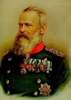
The Bismarck Tower on the 497-metre-high Peterskopf in the Haardt mountains on the eastern edge of the Palatine Forest stands within an exclave of the municipality of Kallstadt in the German state of Rhineland-Palatinate.

Merzalbe river in Germany

The Merzalbe, also called the Merzalb, is a stream, over 12 km (7.5 mi) long, in the Western Palatinate in the German state of Rhineland-Palatinate. It is an orographically right tributary of the Rodalb. In its upper reaches it is also called Mühlgraben.

Schänzel Tower Tower near Edenkoben, Germany

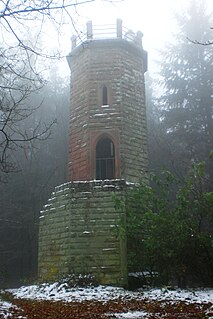
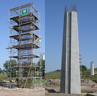
The Schänzel Tower is a 13-metre-high viewing tower on the Steigerkopf near Edenkoben in the county of Südliche Weinstraße in the German state of Rhineland-Palatinate. It was built in 1874 and is the highest-located tower in the mountain range of the Palatinate Forest.

Hohloh mountain

The Hohloh is a mountain, 988.3 m above sea level (NHN), on the eastern main ridge of the Northern Black Forest in Germany. It lies near the village of Kaltenbronn in the borough of Gernsbach, a town in the county of Rastatt in the German state of Baden-Württemberg. Its summit is the highest point in the borough of Gernsbach and the eastern chain of the Northern Black Forest, the ridge between the rivers Murg and Enz. A mountain pass runs northeast of the summit plateau between the two river valleys passing over the saddle of Schwarzmiss.

Hochsimmer mountain

The Hochsimmer is a volcanic cone, 587.9 m above sea level (NHN), in the Eifel Mountains in Germany. It rises near Ettringen in the Rhineland-Palatine county of Mayen-Koblenz. At the summit is an observation tower, the Hochsimmer Tower.

References

  1. Topographic map of Bavaria 1:25,000 series. Merzalben sheet, 1912 edition.
  2. Lang (2009) pp. 71–82
  3. Marianne Teuscher: Liebe auf den ersten Blick. (pdf, 145 KB) [ permanent dead link ] Article in Die Rheinpfalz on 25 September 2009.
  4. Lang (2009) p. 82, has assessed its costs in present-day terms (as at 2000) with the assistance of a specific construction cost index as €256,000. In doing so he referred to Rolf Brachmann/Peter Holzner/Franz Wilhelm Ross: Ermittlung des Bauwertes von Gebäuden und des Verkehrswertes von Grundstücken. 28th edn., Oppermann Verlag, Hanover, 1997
  5. Lang (2009), p. 82
  6. Lang (2009), p. 84
  7. Luitpoldturmverein e. V.: Satzung [ permanent dead link ]. Retrieved on 3 October 2011
  8. Lang (2009), pp. 108–121
  9. Lang (2009), pp. 84–85

Literature

Coordinates: 49°15′9.4″N7°49′32.3″E / 49.252611°N 7.825639°E / 49.252611; 7.825639