The Palatine Forest Club is a hiking club in the former Bavarian Palatinate, i.e. the southern part of the German state of Rhineland-Palatinate and the Saarland county of Saarpfalz-Kreis. In 2011 it had 221 local branches with around 27,000 members.
German is a West Germanic language that is mainly spoken in Central Europe. It is the most widely spoken and official or co-official language in Germany, Austria, Switzerland, South Tyrol (Italy), the German-speaking Community of Belgium, and Liechtenstein. It is also one of the three official languages of Luxembourg and a co-official language in the Opole Voivodeship in Poland. The languages which are most similar to German are the other members of the West Germanic language branch: Afrikaans, Dutch, English, the Frisian languages, Low German/Low Saxon, Luxembourgish, and Yiddish. There are also strong similarities in vocabulary with Danish, Norwegian and Swedish, although those belong to the North Germanic group. German is the second most widely spoken Germanic language, after English.
The Dahner Felsenland, also referred to as the Dahn Rockland, is a landscape in the county of Südwestpfalz in the German federal state of Rhineland-Palatinate. It is located in the middle section of the Wasgau, which in turn forms the southern part of the Palatine Forest and the northern part of the Vosges in France. The Dahner Felsenland has numerous rock formations within the South Palatinate Climbing Area.
The Palatine Ways of St. James are those sections of the Way of St. James in the Palatinate region of Germany and part of the historic pilgrimage route to the northwest Spanish town of Santiago de Compostela. It was there that, according to Christian tradition, the Apostle Saint James the Greater was buried.
Speyer is a town in Rhineland-Palatinate, Germany, with approximately 50,000 inhabitants. Located beside the river Rhine, Speyer is 25 km south of Ludwigshafen and Mannheim. Founded by the Romans, it is one of Germany's oldest cities. Speyer is dominated by the Speyer Cathedral, a number of churches and the Altpörtel. In the cathedral, beneath the high altar, are the tombs of eight Holy Roman Emperors and German kings.
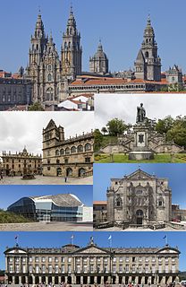
Santiago de Compostela is the capital of the autonomous community of Galicia, in northwestern Spain.
Ireland is an island in the North Atlantic. It is separated from Great Britain to its east by the North Channel, the Irish Sea, and St George's Channel. Ireland is the second-largest island of the British Isles, the third-largest in Europe, and the twentieth-largest on Earth.
Turkey, officially the Republic of Turkey, is a transcontinental country located mainly in Western Asia, with a smaller portion on the Balkan Peninsula in Southeast Europe. East Thrace, located in Europe, is separated from Anatolia by the Sea of Marmara, the Bosphorous strait and the Dardanelles. Turkey is bordered by Greece and Bulgaria to its northwest; Georgia to its northeast; Armenia, the Azerbaijani exclave of Nakhchivan and Iran to the east; and Iraq and Syria to the south. Istanbul is the largest city, but more central Ankara is the capital. Approximately 70 to 80 per cent of the country's citizens identify as Turkish. Kurds are the largest minority; the size of the Kurdish population is a subject of dispute with estimates placing the figure at anywhere from 12 to 25 per cent of the population.
along the red cross trail from Johanniskreuz over the Eschkopf and Edenkoben to Speyer.[3]
Hochspeyer is a municipality in the district of Kaiserslautern, in Rhineland-Palatinate, Germany. It is situated in the Palatinate forest, approx. 10 km east of Kaiserslautern.
Johanniskreuz is a tiny hamlet in the middle of the Palatine Forest in Germany and belongs to the municipality of Trippstadt in the district of Kaiserslautern in the state of Rhineland-Palatinate.
The Eschkopf near Hofstätten in the German state of Rhineland-Palatinate is a major hill, 608.3 m above sea level (NHN) high in the Palatine Forest.
The international Nahegau-Wasgau-Vosges long distance path is waymarked by a white cross and runs from Niederhausen an der Nahe over the Donnersberg, the Schorlenberg, via Hochspeyer and Waldleiningen to Johanniskreuz (to here it is part of the southern branch of the E8 European long distance path). From Johanniskreuz, the trail runs via Leimen and Münchweiler an der Rodalb to Pirmasens. Heading for France, the route then runs via Pirmasens-Erlenbrunn, the Palatine Forest Club hut of Drei Buchen, Eppenbrunn, the Altschlossfelsen rocks and then over the border to Bitche and Wingen-sur-Moder in France.
Waldleiningen is a municipality in the district of Kaiserslautern, in Rhineland-Palatinate, western Germany.
Münchweiler an der Rodalb is a municipality in Südwestpfalz district, in Rhineland-Palatinate, Germany and belongs to the municipal association of Rodalben. The primary industry of the village was that of a shoe manufacturer. It lies on Strasse B-10 between Karlsruhe and Pirmasens.
Pirmasens is an independent town in Rhineland-Palatinate, Germany, near the border with France. It was famous for the manufacture of shoes. The surrounding rural district was called Landkreis Pirmasens from 1818 until 1997, when it was renamed to Südwestpfalz.
The international Donnersberg-Donon long distance path is waymarked by a red bar and runs from Bad Kreuznach through the Donnersberg area and Palatine Forest to the Donon in Alsace. Its route through the Palatine Forest takes it via Kaiserslautern, the Aschbacherhof, Trippstadt, past Oberhammer and Leimen to the ruins of Gräfenstein Castle. From there it continues via Hinterweidenthal and the Neudahn Castle ruins, through Dahn, Bruchweiler and Rumbach to the French border at the Emperor William Rock (Kaiser-Wilhelm-Stein). The trail is designated as GR 53 on the French side and runs in several stages through the Alsace to the summit of the Donon.
The international Pirmasens-Belfort long distance path is waymarked by a yellow bar and runs Pirmasens to Belfort south of the Vosges. Details of the various stages of the route are given below.
National long distance paths
Several paths run past the bathing lake of Helmbachweiher
The Franconia-Hesse-Palatinate long distance path (Fernwanderweg Franken-Hessen-Kurpfalz) runs from Aschaffenburg via Speyer and finally through the Palatine Forest, waymarked with a red cross, to Lichtenberg Castle. Its route through the Forest goes fromd Edenkoben, NaturfreundehausSauermilchtälchen, via Taubensuhl and the Eschkopf to Johanniskreuz (to this point it is part of the southern branch of the E 8 European long distance path). From Johanniskreuz it continues to the Oberhammer and through the Karlstal valley to the Friends of Nature house (Naturfreundehaus) of Finsterbrunnertal, then runs past the Gelterswoog to Landstuhl. Passing Kusel the path finally reaches Lichtenberg Castle.
Saar-Rhine trails
These two trails run from Saarbrücken through the Palatine Forest to the River Rhine near Wörth.
This section lists the walking routes of the Palatine Forest region.
Walking network of the Palatine Forest
Paths through Johanniskreuz (waymark: coloured cross)
In addition to the long distance paths waymarked by a white cross, red cross and yellow cross, all other paths in the Palatine Forest that are marked with a cross pass through the hamlet of Johanniskreuz (the name means "St John's Cross"):
On the West Palatinate Way, waymarked with a coloured letter W, the Association for the Promotion of Tourism in the West Palatinate (Verein zur Förderung des Tourismus in der Westpfalz) used to offer guided tours with luggage transfer. Both this service and its waymarking have not been maintained since 2009.[4]
Waymark: coloured bars
Green and blue bars: this route runs from Göllheim to Eppenbrunn. Its waypoints include Alsenborn, Frankenstein, Schwarzsohl Hut (PWV), Breitenstein, Eußerthal, Rinnthal, Schwanheim and Erfweiler.
Green and white bars: starting at Wasener Kreuz (west of Hertlingshausen, on the A6 motorway) this route runs through Lambertskreuz, Neidenfels, Esthal, Breitenstein, Forsthaus Heldenstein and St. Martin.
White and blue bars: the second route with this waymark is further east in the Palatine Forest. The starting point os Battenberg. Running past the Hardenburg castle, Eckkopf (west of Deidesheim), with a branch to the Stabenberg mountain, and Weinbiet to Neustadt an der Weinstraße, Haßloch, Germersheim before ending in Wörth am Rhein.
White and red bars: one path with this waymark runs from the Palatine Forest to Speyer on the Rhine. Its waypoints are Kaiserslautern, Waldleiningen, Schwarzsohl, Esthal, Erfenstein, Hellerplatz, Neustadt an der Weinstraße, Ordenswald/Haßloch, Fronmühle and Speyer.
White and red bars: another route with this waymark begins in the Krumbachtal valley, runs to Bad Dürkheim, continues along the edge of the Haardt mountains, before passing Heidenlöcher, St. Michael's Chapel near Deidesheim and Gimmeldingen before reaching Neustadt.
Blue and red bars: the footpath starts in Kirchheimbolanden and runs via Elmstein, Iggelbach, Hofstätten, Hermersberger Hof and Hinterweidenthal toPirmasens.
Yellow and red bars: One of these waymarked paths is unusual in that it does not begin (or end, depending on your viewpoint) in a settlement, but on the B 48 federal road in Wellbachtal. Its route takes it through Wilgartswiesen, Hauenstein, Dahn, Schindhard, past the ruins of Lindelbrunn Castle, through Silz and the ruins of Landeck, out of the Palatine Forest into the Anterior Palatinate to Rülzheim.
Yellow and red bars: the other route with this waymarking begins at Lichtenberg Castle, heading for Wallhalben. It then runs via Thaleischweiler-Fröschen, Burgalben, along the valley of Schwarzbachtal, over the Eschkopf, through Elmstein, Esthal and Mainzertal (on the B 39 federal road), and past the Drachenfels before finishing in Wachenheim.
Red and white bars: beginning in Niederwürzbach the route passed through Erfweiler, Hauenstein, Hermersberger Hof, Eußerthal, Dernbach and Gleisweiler before ending in Böchingen.
Yellow bar: the walk begins near Blieskastel and runs through Contwig, Leimen (Pfalz), Hofstätten, Taubensuhl (Landau Municipal Forest), Eußerthal and Annweiler before reaching Germersheim am Rhein.
Yellow bar: the second path with this waymark in the Palatine Forest is part of the Pirmasens-Belfort long distance path and is located further south in the Palatine Forest. Its westernmost point is the town of Pirmasens. It then heads for Dahn, Busenberg, Erlenbach (near Dahn), Birkenhördt, Bad Bergzabern, Schweigen-Rechtenbach, Weißenburg/Wissembourg (F) and ends in Belfort.
Yellow bar: the third path with this waymarking runs from Glanbrücken to Eiswoog, Frankenstein, Friedrichsbrunnen, Lambertskreuz and Wachenheim.
Red bar: another sign used on several paths. For the first one, see above in the section on international long distance paths. The second one is a very short trail starting at Lambertskreuz, then running via Neidenfels, Lambrecht and Hellerplatz to Breitenstein.
Red bar: the third route begins in Neuleiningen, crosses Bad Dürkheim and Wachenheim, continues along the edge of the Haardt to Neustadt an der Weinstraße, St. Martin, Frankweiler and Siebeldingen.
Blue bar: branching off the above long distance path with this marking, it is a short stretch from Drei Buchen ("Three Beeches") to Burrweiler an der Weinstraße.
Yellow dot: from Kettrichhof along the Hohe Straße ("High Road") to Lemberg, past the Maiblumenfels and the annex of Salzwoog to Hinterweidenthal. From there via Vier Buchen and Winterkirchel to the PWV hut of Dicke Eiche ("Fat Oak") and then to Erfweiler. Finally it goes via Dahn and the Napoleonsfelsen rocks to Fischbach.
White dot: this waymark is found where link paths have been established between the main routes and walking trails. It is possible to switch to another route. These signs are, however, rather uncommon.
Certified paths
The Palatinate Tourist Office worked in cooperation with the Association of German Mountain and Hiking Clubs (Deutscher Wanderverband) on the routes for three certified paths which were opened in April 2011, two of which run through the Palatine Forest:
The Monk's Way (Mönchsweg) themed walk near Hochspeyer
Baumwipfelpfad ("Treetop Path") – at the Fischbach Biosphere House. The path, for which a fee is payable, runs through the trees and treetops at heights of up to 35metres for a distance of 270metres. Nearby there is a Water Experience Way (Wasser-Erlebnis-Weg).
Waterway trail on the Moosalbe (Gewässerwanderweg an der Moosalbe) – this is one of seven walks on the subject of water engineering in Rhineland-Palatinate. The way runs for over 33km along the Moosalbe and Hirschalbe streams. Information provided by the Ministry for the Environment and Forests[5] at various waypoints covers the topics of:
Keltenweg ("Celtic Way" and Römerweg ("Roman Way") (9km)
Mönchsweg ("Monk's Way")I (12km) und MönchswegII (14km)
Schanzenweg ("Fieldwork Way") (13km)
Sonnwendweg ("Solstice Way") (9km)
Skulpturenweg Rheinland-Pfalz ("Rhineland-Palatinate Sculpture Way") – this sculpture walk is planned in future to run through the whole of Rhineland-Palatinate. It currently comprises local sections.[7] These are found in the Palatine Forest at:
Spurensuche ("Tracking") – four forest history walks in the Johanniskreuz forest district:
Footpath (Weg) 1 (yellow, 21km, 21 stations) via Lauberhof, Karlstal and Meiserhof.
Footpath 2 (red, 14.5km, 21 stations) via Erlenbach and Eschkopf.
Footpath 3 (blue, 19.5km, 21 Stations) via Dämmchen, Mückenwiese and Speyerbrunn.
Footpath 4 (green, 19km, 22 Stations, not from Johanniskreuz, but Trippstadt) via Antonihof and Aschbacherhof.
The Rodalber Felsenweg ("Rodalb Rock Way", circular path, 43.305km, 5 stages are recommended that increase the total length, including approach and departure routes to 61.9km) was laid out by the Palatinate Forest Club and the municipalities of Rodalben in the early 1990s. It snakes through various side valleys around Rodalben and passes 26 bizarre rock formations of bunter sandstone that are typical of the region. In 2007 it was elevated by the German Rambling Association to a certified trail.
The Brunnenwanderweg ("Fountain Trail") near Heltersberg: the trail was opened in 2009 and is 40.3km long, has 64 theme-related stations and in the area around the village of Heltersberg. The 30 or so voluntary renovated fountains form the highlight of the path; other features include near-natural, unique mixed woods and bizarre rock formations (crags and blockfields). The cultural historic background to the trail is documented on detailed information boards and a guide brochure.[8]
Local footpaths
Many villages and municipalities in the Palatine Forest have marked out local footpaths. These circular routes are usually waymarked with numbers and are of short to medium length, mainly used by local people. The care of these circular walks (waymarking, clearing) has been very neglected in recent years due to lower demand and tighter budgets. As a result, some can only be located with the aid of topographic maps.
Common waymarking systems
Since the foundation of the Palatine Forest Club and the Vosges Club (French: Club Vosgien) about 100 years ago, both rambling clubs have used almost identical waymarking systems. As a result, not only are cross-border walks made very easy but it also supports the fact that the Palatinate Forest and the Vosges form a single unit from both a geomorphological and a topographical perspective, and should therefore really only be viewed as two halves of an overarching mountain range on the left bank of the Rhine.[9][10]
Literature
Klaus Frölich: Natur und Kultur an den Wanderwegen des PWV, Teil I: Kreuzmarkierungen. In: Pfälzerwaldverein (Hrsg): Wanderführer, Broschüren usw.. Selbstverlag Neustadt/W. 2006.
Klaus Frölich: Burgenwanderweg – Teil II. In: Pfälzerwaldverein (Hrsg): Wanderführer, Broschüren usw.. Selbstverlag Neustadt/W. o. J.
Pfälzerwaldverein (Hrsg): Zabernweg-Führer, Wanderweg zwischen Rheinzabern – Bad Bergzabern – Saverne (170 km). Selbstverlag Neustadt/W. o. J.
Kurt Reh: Der Pfälzerwald - eine Einführung in Landschaft und Namengebung.In: Michael Geiger u. a. (Hrsg): Pfälzische Landeskunde, Beiträge zu Geographie, Biologie, Volkskunde und Geschichte. Bd. 1. Selbstverlag, Landau/Pf. 1981, S. 379-388.
Barbara Christine Titz, Jörg-Thomas Titz: Pfälzerwald und Deutsche Weinstraße: 50 ausgewählte Tal- und Höhenwanderungen der Region Leiningerland, Haardt, Weinstraße und Pfälzerwald. 4. Auflage. Bergverlag Rother, Oberhaching 2009, ISBN978-3-7633-4268-6.
Neustadt an der Weinstraße is a town in Rhineland-Palatinate, Germany. With 54,000 inhabitants as of 2002, it is the largest town called Neustadt.
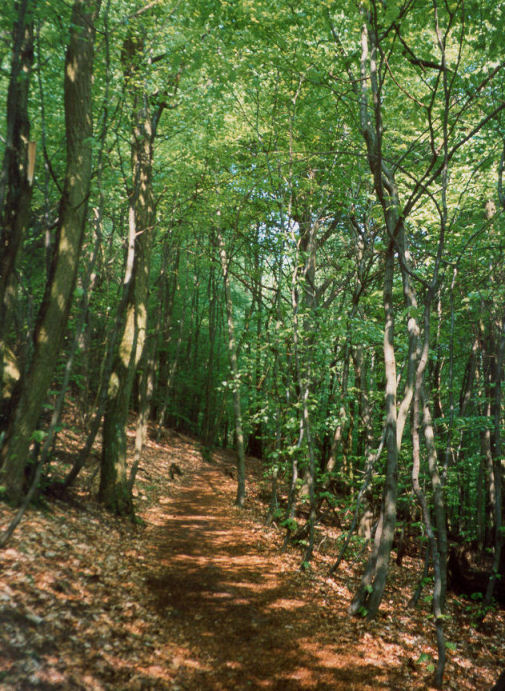
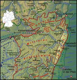
The Palatinate Forest, sometimes also called the Palatine Forest, is a low-mountain region in southwestern Germany, located in the Palatinate in the state of Rhineland-Palatinate. The forest is a designated nature park covering 1,771 km2 and its highest elevation is the Kalmit.
The Kalmit is the highest peak in the Palatinate Forest and the second highest in the Palatinate region of Germany. It is 672.6 m above sea level (NHN) and located 5.5 kilometres (3.4 mi) south of the town of Neustadt an der Weinstraße.
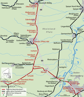
The Neustadt–Wissembourg railway, also called the Pfälzische Maximiliansbahn, Maximiliansbahn or just the Maxbahn - is a railway line in southwestern Germany that runs from Neustadt an der Weinstrasse to Wissembourg in Alsace, France. The Palatine Maximilian Railway also included a branch from Winden via Wörth and the Maxaubahn to Karlsruhe.
Neustadt (Weinstr) Hauptbahnhof – called Neustadt a/d. Haardt until 1935 and from 1945 until 1950 – is the central station of in the city of Neustadt in the German state of Rhineland-Palatinate. In addition to the Hauptbahnhof, Rhine-Neckar S-Bahn services stop at Neustadt (Weinstr) Böbig halt (Haltepunkt). Mußbach station and Neustadt (Weinstr) halt, opened on 19 November 2013, are also located in Neustadt.
The Landau–Rohrbach railway is a major line running from Landau in the German state of Rhineland-Palatinate to Rohrbach in the Saarland. The main section between Landau and Zweibrücken was opened on 25 November 1875 after the first sections had already been opened between 1857 and 1867.
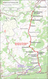
The Alsenz Valley Railway is a line that runs from Hochspeyer via Winnweiler and Alsenz to Bad Munster am Stein in the German state of Rhineland-Palatinate. The line follows the Alsenz river from the Enkenbach district and crossed it several times. It was originally built primarily as a long-distance route, but it has lost this function since 1990 and is now exclusively used for local transport.
The Leininger Sporn is a highly prominent ridge in the northeast of the Palatinate Forest in western Germany, mainly composed of the rock formations of the Middle and Upper Bunter. It forms the western edge of Upper Rhine Plain between Grünstadt in the north and Leistadt, a village in the county of Bad Durkheim, in the southeast. In the natural region system of the German Central Uplands it is considered one of the four sub-units of the Middle Palatinate Forest.
The Frankenweide is a hill region in the German state of Rhineland-Palatinate. It forms the central part of the Palatine Forest in the Palatinate region.
The Hohe Loog, is a mountain, 619 m above sea level (NN), in the Haardt, the eastern rim of the Palatine Forest in Germany. The mountain lies within the borough of Neustadt an der Weinstraße in the southern part of the state of Rhineland-Palatinate.
The Taubenkopf is a hill, about 604 metres (1,982 ft) high, in the German state of Rhineland-Palatinate. It is part of the mountain chain of the Haardt in the Palatine Forest and lies in the municipal territory of Diedesfeld in the borough of Neustadt an der Weinstraße.
The West Palatinate Way was a marked footpath that crossed the West Palatinate region in Germany, but is no longer maintained. The concept for this route emerged in 1980 from its sponsor the Association for the Promotion of Tourism in the West Palatinate and was a cooperative venture between the counties in the West Palatinate, the Palatine Forest Club and local pubs and restaurants. In 2006 and 2007, overnight bookings fell and, since 2009, the sponsors have no longer taken bookings and maintenance of the footpath and its waymarks has only been carried out in places by the Palatinate Club. The disbandment of the tourist association has also been discussed.
The Weinstraße, also referred to as the Middle Haardt (Mittelhardt), is a region within the Palatinate in the German state of Rhineland-Palatinate that was named after the German Wine Road or Deutsche Weinstraße.
The Kalmithaus, also called the Ludwigshafener Hut, near Maikammer in the Rhineland-Palatinate county of Südliche Weinstraße is a refuge hut in the Palatinate Forest run by the Ludwigshafen-Mannheim branch of the Palatinate Forest Club. It is located in the southern part of the Haardt mountains at the summit of its highest peak, the Kalmit, and is thus the highest hut in the Palatinate Forest. From its terrace there is often a stunning view of the Upper Rhine Plain as far as the foothills of the southern Odenwald and northern Black Forest. Immediately next to the hut is the observation tower on the Kalmit, which is out of bounds to the public, and houses a radio relay station, a weather station and a visibility survey station.
The Hüttenberg near Maikammer in the Rhineland-Palatinate county of Südliche Weinstraße is a subpeak, 620.1 m above sea level (NN), of the Kalmit the highest mountain in the Haardt in the eastern Palatinate Forest of Germany. There is a blockfield, the Hüttenberg Felsenmeer, along the crest.
Enkenbach station is the only station in Enkenbach-Alsenborn in the German state of Rhineland-Palatinate. It has two platforms tracks and is located in the network of the Verkehrsverbund Rhein-Neckar and belongs to fare zone 828. Its address is Bahnhofstraße 2.
↑ Naturpark Pfälzerwald, Wander- und Erlebniskarte 1:50,000, ISBN3-927416-44-4.
↑ Die Rheinpfalz, Südwestdeutsche Zeitung: Hat sich das „W“ totgelaufen?, 3 April 2009
↑ Ministerium für Umwelt und Forsten Rheinland-Pfalz. "Gewässerwanderwege". Landesamt für Umwelt, Wasserwirtschaft und Gewerbeaufsicht Rheinland-Pfalz. Retrieved 16 June 2008.
↑ I. Christmann, S. Tie. "Rätselhafte Zeitzeichen". Verbandsgemeinden Enkenbach-Alsenborn und Hochspeyer. Retrieved 29 November 2009.
↑ Prof. Dr.-Ing. Dieter Wüstenberg. "Skulpturenweg". Skulpturenweg Rheinland-Pfalz e.V. Retrieved 15 June 2008.
↑ Kurt Reh: Der Pfälzerwald - Eine Einführung in Landschaft und Namengebung. In: Michael Geiger et al. (ed): Pfälzische Landeskunde, Beiträge zu Geographie, Biologie, Volkskunde und Geschichte. Vol. 1. Selbstverlag, Landau/Pf. 1981, p. 381.
This page is based on this Wikipedia article Text is available under the CC BY-SA 4.0 license; additional terms may apply. Images, videos and audio are available under their respective licenses.