Elmstein valley

Last updated
Elmstein valley
Elmsteiner Tal (German)
Elmstein mit burg.jpg
Village and ruined castle of Elmstein
Rhineland-Palatinate location map.svg
Red pog.svg
Elmstein valley
Floor elevation170 m
Length24 km
Depth300 m
Geology
TypeBunter sandstone
Geography
Coordinates 49°20′48″N7°56′52″E / 49.34667°N 7.94778°E / 49.34667; 7.94778 Coordinates: 49°20′48″N7°56′52″E / 49.34667°N 7.94778°E / 49.34667; 7.94778
Mountain rangecentral Palatine Forest
Rivers Speyerbach and tributaries

The Elmstein valley (German : Elmsteiner Tal) runs through the central Palatine Forest region between the villages of Frankeneck and Johanniskreuz in the German state of Rhineland-Palatinate. The Speyerbach stream, a left tributary of the Rhine, flows through the valley.

Contents

Geography

Location

Most of the Elmstein valley lies within the county of Bad Dürkheim; two smaller segments belong to Neustadt an der Weinstraße and the county of Südliche Weinstraße. The valley is 24 kilometres long and descends from west to east from about 470 to 170 metres above sea level.

Waterbodies

The Speyerbach stream flows through the Elmstein valley. Together with its tributary streams, the biggest of which are the Helmbach and the Breitenbach, the Speyerbach drains the winding valley and the heights surrounding it.

Hills

The hills on the left-hand or northern side of the valley reach a maximum height above sea level of 514 metres in the Mückenberg and are clearly lower than those opposite. On the right hand, southern, side the Bloskülb (570 m) and the Brogberg (567 m) are the highest peaks. The highest point in the west, also the start of the valley, lies on the watershed between the Rhine and Moselle rivers, separating here the catchment areas of the Speyerbach and Schwarzbach. In the east the valley ends at the confluence of the Hochspeyerbach with the Speyerbach.

Sights

Structures

Spangenberg Castle Burgspangenbergrp.jpg
Spangenberg Castle
Church tower ruins at Appenthal Appenthal.JPG
Church tower ruins at Appenthal

The four medieval castles above the valley, namely Elmstein, Breitenstein, Erfenstein and Spangenberg, guarded the sovereignty of the local territorial lords here for centuries. Today their ruins are visited by tourists, not least because of the legend of the Leather Bridge that is supposed to have existed between Erfenstein and Spangenberg. The best known of the remaining structures in the valley is the ruined tower of the 1488 church in Appenthal. [1]

Museums and themed walk

Three museums inform visitors to Elmstein about forestry; two of them are located in the same historic building. The Forestry Museum (Waldarbeitsmuseum) in the upper storey is concerned with comprehensively covering all activities relevant to the forest. [2] [3] The Armoury (Wappenschmiede) on the ground floor is an iron hammer mill, that once used the waters of the Speyerbach for power for the smith's trade; today it produces electrical power that is fed into the public network. [4] Die Alte Samenklenge hat speziell die Geschichte der Forstwirtschaft zum Thema und gibt Auskunft über Nutzung der Wälder, Samengewinnung und Aufforstung. [5]

The information board of the Trift Way (Triftwanderweg) along the Speyerbach explains the technology associated with timber rafting. [6] Die Touristinformation der Gemeinde Elmstein bietet geführte Wanderungen an. [7]

Economy and infrastructure

Economy

From the Middle Ages to the Modern Period, forestry was the main source of income in the whole region. Numerous log driving facilities were used to transport sawn timber on the streams, whose water power was also used to drive water mills and hammer mills.

Settlement

The valley is very sparsely populated; its population is under 3,000. Its most important parish is Elmstein, from which the valley derives its name. With the decline of forestry, more and more locals commute out of the valley to work.

Transport

Locomotive on the Cuckoo Railway at Elmstein station Elmstein bhf-2.JPG
Locomotive on the Cuckoo Railway at Elmstein station

The valley is served by the Landesstraße 499 state road, which runs from Frankeneck to Johanniskreuz, linking the B 39 (FrankensteinNeustadt an der Weinstraße) and B 48 federal highways (HochspeyerBad Bergzabern). In addition there is a bus service, number 517 (Neustadt an der Weinstraße–Iggelbach), which has a journey time of about an hour.

To reduce motorcycle accidents, the very winding road through the valley is closed to motorcycle traffic in the summer half-year (April to October); only residents, not visitors, may use motorcycles on the road during the out of bounds period.

The Cuckoo Railway (Kuckucksbähnel) runs along the Speyerbach from Frankeneck to Elmstein. This line was opened in 1909 and ran passenger services until 1960. In 1984 the line was reactivated and has since been run as a heritage railway for tourists.

Related Research Articles

<span class="mw-page-title-main">Neustadt an der Weinstraße</span> Town in Rhineland-Palatinate, Germany

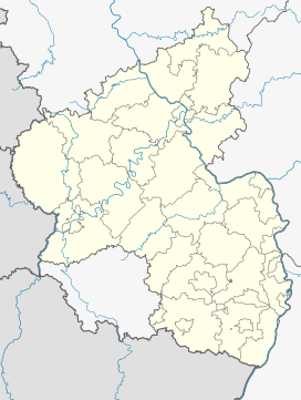
Neustadt an der Weinstraße is a town in Rhineland-Palatinate, Germany. With 53,300 inhabitants as of 2020, it is the largest town called Neustadt.

<span class="mw-page-title-main">Palatinate Forest</span> Low mountain range in Germany

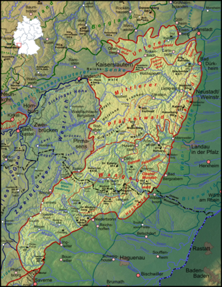
The Palatinate Forest, sometimes also called the Palatine Forest, is a low-mountain region in southwestern Germany, located in the Palatinate in the state of Rhineland-Palatinate. The forest is a designated nature park covering 1,771 km2 and its highest elevation is the Kalmit.

<span class="mw-page-title-main">Lambrecht, Rhineland-Palatinate</span> Town in Rhineland-Palatinate, Germany

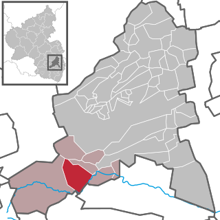
Lambrecht is a town in the Bad Dürkheim district in Rhineland-Palatinate, Germany lying roughly 6 km northwest of Neustadt an der Weinstraße. It is the seat of the like-named Verbandsgemeinde.

<span class="mw-page-title-main">Elmstein</span> Municipality in Rhineland-Palatinate, Germany

Elmstein is an Ortsgemeinde – a municipality belonging to a Verbandsgemeinde, a kind of collective municipality – in the Bad Dürkheim district in Rhineland-Palatinate, Germany.

<span class="mw-page-title-main">Esthal</span> Municipality in Rhineland-Palatinate, Germany

Esthal is an Ortsgemeinde – a municipality belonging to a Verbandsgemeinde, a kind of collective municipality – in the Bad Dürkheim district in Rhineland-Palatinate, Germany.

<span class="mw-page-title-main">Frankeneck</span> Municipality in Rhineland-Palatinate, Germany

Frankeneck is an Ortsgemeinde – a municipality belonging to a Verbandsgemeinde, a kind of collective municipality – in the Bad Dürkheim district in Rhineland-Palatinate, Germany.

<span class="mw-page-title-main">Kirchheim an der Weinstraße</span> Municipality in Rhineland-Palatinate, Germany

Kirchheim an der Weinstraße is an Ortsgemeinde – a municipality belonging to a Verbandsgemeinde, a kind of collective municipality – in the Bad Dürkheim district in Rhineland-Palatinate, Germany.

<span class="mw-page-title-main">Kleinkarlbach</span> Municipality in Rhineland-Palatinate, Germany

Kleinkarlbach is an Ortsgemeinde – a municipality belonging to a Verbandsgemeinde, a kind of collective municipality – in the Bad Dürkheim district in Rhineland-Palatinate, Germany.

<span class="mw-page-title-main">Spangenberg Castle (Rhineland-Palatinate)</span>

Spangenberg Castle is the partially rebuilt ruin of a rock castle in the German state of Rhineland-Palatinate. It lies in the Palatine Forest above the Elmstein valley near the village of Erfenstein, but is actually on the forest estates belong to the town of Neustadt an der Weinstraße, or more precisely, the village of Lachen-Speyerdorf. Together with the neighbouring castle of Erfenstein, it is linked to the legend of the Leather Bridge.

<span class="mw-page-title-main">Neustadt (Weinstraße) Hauptbahnhof</span>

Neustadt (Weinstr) Hauptbahnhof – called Neustadt a/d. Haardt until 1935 and from 1945 until 1950 – is the central station of in the city of Neustadt in the German state of Rhineland-Palatinate. In addition to the Hauptbahnhof, Rhine-Neckar S-Bahn services stop at Neustadt (Weinstr) Böbig halt (Haltepunkt). Mußbach station and Neustadt (Weinstr) halt, opened on 19 November 2013, are also located in Neustadt.

<span class="mw-page-title-main">Speyerbach</span> River in Germany

The Speyerbach is a left tributary of the Rhine in the Palatinate part of Rhineland-Palatinate. In Speyer, the river split into Gießhübelbach and Woogbach. The Woogbach changes its name to Nonnenbach, then flows into Gießhübelbach shortly before the latter flows into the Rhine.

<span class="mw-page-title-main">Rehbach (Palatinate)</span> River in Germany

The Rehbach is a river in Rhineland-Palatinate. It is about 29 kilometres (18 mi) long and is a left tributary of the Rhine.

<span class="mw-page-title-main">Mußbach</span> Stream in Germany

The Mußbach is a stream, nearly 12 kilometres (7.5 mi) long, in the eastern Palatinate Forest and in the Anterior Palatinate region in the south of German state of Rhineland-Palatinate. The former village of Mußbach was named after it.

<span class="mw-page-title-main">Weinbiet</span>

The Weinbiet is a hill, 554 m above sea level (NHN), in the borough of Neustadt an der Weinstraße in the German state of Rhineland-Palatinate and is one of the highest hills in the Haardt, the line of mountains and hills forming the eastern edge of the Palatine Forest and facing the Upper Rhine Plain. On the summit is an inn, the Weinbiethaus, a stone-built panorama tower with a weather station and a radio transmission mast.

<span class="mw-page-title-main">Walking routes in the Palatine Forest</span>

Walking routes in the Palatine Forest fall into two categories. The first are longer walking routes, most of which are maintained by the Palatine Forest Club, or PWV, and which are linked to the national and international network of long distance paths. The second category are those local circular walks and themed walking routes, some of which are of wider regional importance, and which are maintained by municipal authorities. The Palatine Forest, as part of the Palatine Forest-North Vosges Biosphere Reserve, is an important conservation area. As a result, the Palatine Forest, the bunter sandstone landscape of the Palatine Forest Nature Park, the castles in the Dahner Felsenland and the cross-border paths into Alsace and the Vosges make the region particularly popular with ramblers and walkers.

<span class="mw-page-title-main">Johanniskreuz</span> Ortsteil of Trippstadt in Rhineland-Palatinate, Germany

Johanniskreuz is a tiny hamlet in the middle of the Palatine Forest in Germany and belongs to the municipality of Trippstadt in the district of Kaiserslautern in the state of Rhineland-Palatinate.

<span class="mw-page-title-main">Cuckoo Railway</span>

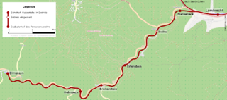
The Cuckoo Railway, in its early days the Elmstein Valley Railway, is a 12.97 kilometre long branch line in the central Palatine Forest, which runs through the region of Neustadt/Kaiserslautern from Lambrecht to Elmstein. It was built primarily to support the local forestry industry.

<span class="mw-page-title-main">Erfenstein Castle</span>

Erfenstein Castle is a medieval spur castle in the German state of Rhineland-Palatinate. It lies within the Palatine Forest above the Elmstein Valley at 265 m above sea level (NN) in the vicinity of the hamlet of Erfenstein in the municipality of Esthal. Together with nearby Spangenberg Castle, it is linked to the legend of the Leather Bridge.

<span class="mw-page-title-main">Palatine Ways of St. James</span> Camino de Santiago pilgrimage routes starting in Germany

The Palatine Ways of St. James are those sections of the Way of St. James in the Palatinate region of Germany and part of the historic pilgrimage route to the northwest Spanish town of Santiago de Compostela. It was there that, according to Christian tradition, the Apostle Saint James the Greater was buried.

<span class="mw-page-title-main">Lambrecht (Pfalz) station</span>

Lambrecht (Pfalz) station is the station of the town of Lambrecht in the German state of Rhineland-Palatinate. Deutsche Bahn classifies it as belonging to category 4 and it has three platform tracks. The station is located in the network of the Verkehrsverbund Rhein-Neckar and belongs to fare zone 121. Its address is Bahnhofstraße 4.

References

  1. Generaldirektion Kulturelles Erbe Rheinland-Pfalz (publ.). "Nachrichtliches Verzeichnis der Kulturdenkmäler Kreis Bad Dürkheim" (pdf). Retrieved 2011-11-03.
  2. webmuseen.de. "Waldarbeitsmuseum" . Retrieved 2011-11-03.
  3. Gemeinde Elmstein. "Sehenswertes in Elmstein – Das Elmsteiner Waldarbeitsmuseum". Archived from the original on 2011-10-28. Retrieved 2011-11-03.
  4. Gemeinde Elmstein. "Sehenswertes in Elmstein – Die Elmsteiner Wappenschmiede". Archived from the original on 2011-10-28. Retrieved 2011-11-03.
  5. Alte Samenklenge. "Das Elmsteiner Museum "Alte Samenklenge"" . Retrieved 2011-11-03.
  6. Wege zum Holz. "Elmstein, Triftwanderweg" . Retrieved 2011-11-03.
  7. Verbandsgemeinde Lambrecht. "Wandern – Triftwanderweg in Elmstein". Archived from the original on 2011-05-19. Retrieved 2011-11-03.