Neudahn Castle

Last updated
Neudahn Castle
Burg Neudahn
Dahn
Neudahn castle from South.jpg
The outer castle gate (left) and striking battery towers
Rhineland-Palatinate location map.svg
Red pog.svg
Neudahn Castle
Germany adm location map.svg
Red pog.svg
Neudahn Castle
Coordinates 49°09′47″N7°45′26″E / 49.1630°N 7.7573°E / 49.1630; 7.7573 Coordinates: 49°09′47″N7°45′26″E / 49.1630°N 7.7573°E / 49.1630; 7.7573
Typerock castle on a spur
CodeDE-RP
Height310 m above  sea level (NN)
Site information
Conditionruins, part-restored
Site history
Builtbefore 1240
Garrison information
Occupants ministeriales

The rock castle of Neudahn, in the southwestern Palatine Forest in the German state of Rhineland-Palatinate, is located at the northern end of an elongated ridge near the town of Dahn. The heart of the castle is situated on one of the sandstone rock outcrops that are typical of the Dahner Felsenland region.

Contents

Geography

Neudahn lies 2 kilometres northwest of Dahn, right of the River Lauter, which is known here in its upper reaches as the Wieslauter. The castle stands atop the Kauertberg hill, about 90 metres above the valley floor. The main castle rock is 310 metres above sea level, that of the lower ward reaches 290 metres. Immediately below the castle the Moosbach stream, which is impounded in a small woog used to feed an old mill, empties into the Wieslauter.

History

The name "Neudahn" ("New Dahn") is rather confusing, because the castle is older than Grafendahn Castle in the nearby group of three castles of Dahn, albeit more recent than Altdahn ("Old Dahn"). Its location enabled it to protect and block the old road running through the Wieslauter valley, the course of which is now used by the B 427 federal highway and the Wieslauter Railway.

The castle was probably built just before 1240 by order of the Bishop of Speyer, because from 1233 to 1236 the office was held by a certain Conrad IV of Dahn. The governing ministerialis was Henry of Dahn, who is also recorded as Henry Mursel of Kropsberg. He was probably granted the castle from the outset as a heritable fief. His second name, like other later heirs, indicates clearly that there were family ties with the South PalatinateKropsburg and Burrweiler.

The castles is first mentioned on 3 May 1285 as Burg Than, an assessment of the estate mentioned in the deed indicating that it must refer to Neudahn. [1] p

Within a hundred years of the castle being built, the Mursel family died out, and its possession passed to the related Altdahn line. Probably razed during the Four Lords' War of 1438 and then rebuilt, the site was again badly damaged during the German Peasants' War in 1525. Because, King Henry II of France stayed overnight at the castle in 1552, it must have been thoroughly renovated before then. After the last lord of Dahn, Ludwig II died in 1603 in his castle at Burrweiler, Neudahn was returned to the Prince-Bishopric of Speyer. From then on the castle was used by the episcopal Amtmann as his headquarters until French troops finally destroyed it in 1689 at the start of the War of the Palatine Succession.

Today the castle appears to visitors largely as it did in the renovation and extension phase in the period after 1525 and after the last destruction.

Safety and restoration measures took place in the 1970s. The site is managed by the Generaldirektion Kulturelles Erbe Rheinland-Pfalz, Direktion Burgen, Schlösser, Altertümer, and, together with Berwartstein Castle, 10 kilometres away, is one of the best preserved castles in the southern Palatine Forest.

Site

Plan of the castle Neudahn Plan.jpg
Plan of the castle
Inner gate and newel tower RP Pfalzerwald Dahn Neudahn 006.jpg
Inner gate and newel tower
North side. From the left: inner gate, newel tower and remains of domestic buildings in the upper ward on the sandstone rocks Burg Neudahn Nordseite.jpg
North side. From the left: inner gate, newel tower and remains of domestic buildings in the upper ward on the sandstone rocks
Embrasures on the southern battery tower Burg Neudahn Geschuetzoeffnung.jpg
Embrasures on the southern battery tower

Left of the place where the original gates were located, in the southeast, are the remains of a tower, 7 metres in diameter. From this tower, parts of a thick defensive wall runs westwards, before bending north. On the steep northern and northeastern side of the hillside the wall has entirely disappeared. It led to the flanking tower at the northern end of the site.

Of the oldest – late Hohenstaufen – castle on the vertically hewn, central rock outcrop, which is just under 20 metres high, the only surviving features are a cistern at the western end and the southern wall of the small palas with its window and door openings. At the northwestern end of the main rock outcrop in the south was a late medieval domestic building and, west of that, a well. A formerly plastered newel tower from the same period on the northwestern edge of the rock outcrop leads up to the upper ward. The actual entrance into the ground floor is, as on many castles, probably not authentic and may have been made for modern visitors, which the date 1975 over the entrance suggests. It also lies outside the inner gate. The historic entrance is inside the gate to the left and at a higher level.

The dominant image of the castle is the two four-storey, roughly 24 metre-high, battery towers on the opposite side. They date to the first half of the 16th century. The west tower measures about 7 metres in height, the east tower, about 10 metres. The thickness of the walls is about 3 metres. Two embrasures (so-called Maulscharten) on the southern battery tower have been ornately carved into the shape of lions' faces. [2]

On the continuation of the hill to the east-southeast the site was protected by a wedge-shaped bastion that was also a recognition feature of Neudahn. Its shape was intended to prevent shells from striking the castle frontally. It protected the upper ward on the more gentle slope of the hill on that side. The bastion and the weapon towers show that, in the late Middle Ages, considerable modifications to the castle were carried out and the lords of the castle took account of the introduction of firearms and cannon.

Related Research Articles

Nassau Castle

Nassau Castle, located in Nassau, Rhineland-Palatinate, Germany, was the original seat of the House of Nassau. The ruins of the castle are situated on a rock outcropping about 120 m (390 ft) above the Lahn River. The House of Nassau was an aristocratic dynasty among whose descendants are the present-day monarchy of the Netherlands and Luxembourg.

Dahn Town in Rhineland-Palatinate, Germany

Dahn is a municipality in the Südwestpfalz district, in Rhineland-Palatinate, Germany. It is situated in the Palatinate Forest, approximately 15 km southeast of Pirmasens, and 25 km west of Landau. It is part of the Verbandsgemeinde of Dahner Felsenland.

Elmstein Castle

Elmstein Castle is a castle ruin built in the High Middle Ages overlooking Elmstein in the Palatinate Forest in the German state of Rhineland-Palatinate. It was built in the 12th century.

Altdahn Castle

Altdahn Castle is a castle ruin in the Palatinate Forest, the German part of the Wasgau region. It is located near the town of Dahn in Rhineland-Palatinate, Germany. It stands 337 metres (1,106 ft) above sea level (NN).

Hardenburg (Bad Dürkheim)

The Hardenburg on the eastern edge of the Palatinate Forest near the Rhineland-Palatinate town of Bad Dürkheim is even as a ruin one of the mightiest castles of Palatinate.

Sooneck Castle

Sooneck Castle is a castle in the upper middle valley of the Rhine, in the Mainz-Bingen district of Rhineland-Palatinate, Germany. It is located near the village of Niederheimbach between Bingen and Bacharach.

Frankenstein Castle, Palatinate

Frankenstein Castle is a medieval fortification on a spur above the village of Frankenstein, Rhineland-Palatinate in the Palatinate Forest in Germany. Its name derives from the local House of Frankenstein.

Wasgau

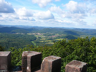
The Wasgau is a Franco-German hill range in the German state of Rhineland-Palatinate and the French departments of Bas-Rhin and Moselle. It is formed from the southern part of the Palatine Forest and the northern part of the Vosges mountains, and extends from the River Queich in the north over the French border to the Col de Saverne in the south.

Castles of Dahn

The castles of Dahn, near the little town of Dahn in the German state of Rhineland-Palatinate, consist of three rock castles:

Grafendahn Castle

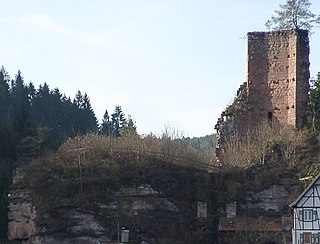
Grafendahn Castle lies in the southern Palatine Forest, the German part of the Wasgau region, just under 1 kilometre east of the small town of Dahn in the state of Rhineland-Palatinate.

Tanstein Castle

Tanstein Castle is the ruin of a rock castle in the southern Palatine Forest, the German part of the Wasgau region. It lies just under a kilometre east of the small town of Dahn in the state of Rhineland-Palatinate.

Murrmirnichtviel Lodge

Murrmirnichtviel Lodge, alternatively spelt Murr-mir-nicht-viel, occasionally Murmel-nicht-viel, is a ruined hunting lodge with a watchtower that used to belong to the counts of Leiningen. It lies in the Palatine Forest southwest of the county town of Bad Dürkheim in the German state of Rhineland-Palatinate.

Schaudichnichtum Lodge was a former hunting lodge southwest of the town of Bad Dürkheim in the German state of Rhineland-Palatinate. Like its near neighbours, Kehrdichannichts, Murrmirnichtviel and Jägerthal, it was used as accommodation for the nobility of the Electoral Palatinate during the 18th century when they went hunting in the Palatine Forest.

Heidelsburg Castle ruins in Germany

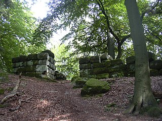
The Heidelsburg, also called the Bunenstein, is an old fortification in the western Palatine Forest in the German state of Rhineland-Palatinate that goes back at least to the days of the Roman Empire. Today only the remains of two gates, together with their steps, the castle walls and a cistern have survived.

House of Dahn

Dahn, also Tan, Tann or Thann, is the surname of a noble family from the Palatinate region of Germany.

Breitenstein Castle

The ruins of Breitenstein Castle stand on a crag, 220 metres (720 ft) high, on the northern side of the Speyerbach valley in the Palatine Forest in Germany. The castles is 4 kilometres (2.5 mi) east of the village of Elmstein in the county of Bad Dürkheim in the state of Rhineland-Palatinate.

Guttenberg Castle (Palatinate)

Guttenberg Castle is a ruined rock castle near the French border in the German part of the Wasgau, which in turn is part of the Palatine Forest in the state of Rhineland-Palatinate.

Frankenburg (Palatinate)

The Frankenburg is a natural monument with the ruins of a rock castle in the county of Südliche Weinstraße in the German state of Rhineland-Palatinate. It lies above the Modenbach valley on a rocky outcrop of the Frankenberg called the Frankenfelsen and was built to guard the road opposite Meistersel Castle.

Old Wolfstein Castle

Old Wolfstein Castle, is a ruined hillside castle on the eastern slopes of the Königsberg at the narrowest point in the Lauter valley near Wolfstein in the county of Kusel in the German state of Rhineland-Palatinate.

Oberburg, Kobern

The Oberburg at Kobern, also called the Oberburg or Altenburg, is a hill castle above the municipality of Kobern-Gondorf in the county of Mayen-Koblenz in the German state of Rhineland-Palatinate.

References

  1. Grathoff 2003, p. 4 (s.  Literature)
  2. Braun 1997, pp. 471.

Literature