
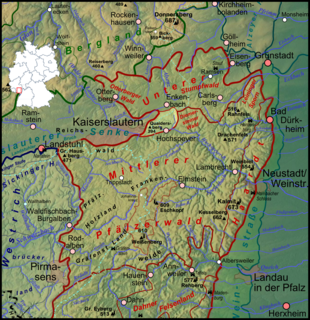
The Palatinate Forest, sometimes also called the Palatine Forest, is a low-mountain region in southwestern Germany, located in the Palatinate in the state of Rhineland-Palatinate. The forest is a designated nature park covering 1,771 km2 and its highest elevation is the Kalmit.

The Kalmit is the highest peak in the Palatinate Forest and the second highest in the Palatinate region of Germany. It is 672.6 m above sea level (NHN) and located 5.5 kilometres (3.4 mi) south of the town of Neustadt an der Weinstraße.

The North Palatine Uplands, sometimes incorrectly shortened to Palatine Uplands, is a low mountain range and landscape unit in the German state of Rhineland-Palatinate and belongs mainly to the Palatinate region. It is part of the Saar-Nahe Uplands.

The Stöcklewald is a mountain, 1,068.2 m above sea level (NHN), in the southern part of the Central Black Forest in Germany between the towns of Furtwangen and Triberg, each about 5 kilometres distant, in the county of Schwarzwald-Baar-Kreis. Towards the north, the Black Forest only exceeds this height again in the area of the Schliffkopf and the Hornisgrinde.

The Clausensee is a reservoir in the Schwarzbach valley in the western Palatine Forest in the German state of Rhineland-Palatinate.

The Blättersberg near Rhodt unter Rietburg in the Rhenish-Palatine county of Südliche Weinstraße is a mountain, 613.2 m above sea level (NHN), in the Palatine Forest in the German state of Rhineland-Palatinate.
The Hohe Stoppelkopf, locally just called the Stoppelkopf, is a 566.2-metre-high hill in the Palatine Forest in the German state of Rhineland-Palatinate. It lies 3 km north of the small town of Lambrecht.

The Eschkopf near Hofstätten in the German state of Rhineland-Palatinate is a major hill, 608.3 m above sea level (NHN) high in the Palatine Forest.

The Hochberg is a 636-metre-high mountain in the central Haardt in the Palatine Forest in Germany. It lies on the territory of the municipality of Sankt Martin (Palatinate) in the county of Südliche Weinstraße in the state of Rhineland-Palatinate. After the Kalmit, the Kesselberg and the Roßberg it is the fourth highest peak in the Palatine Forest.

The Mosisberg near Hofstätten in the German state of Rhineland-Palatinate is a hill, 608.7 m above sea level (NHN), in the central Palatine Forest. It has two domes, the eastern one is the summit and is called Langer Kopf and the western high point is the Preußenstein.

The Weißenberg in the Palatine Forest is a hill in the municipality of Merzalben. Its height is variously give as 610 m above sea level (NHN) or 607 m above NHN. The higher value has been officially recommended since 2011. That makes the Weißenberg the highest point in the west of the mountain range, ahead of the Eschkopf and Mosisberg. As part of the Palatine Forest-North Vosges Biosphere Reserve it is protected by special conservation measures.

Walking routes in the Palatine Forest fall into two categories. The first are longer walking routes, most of which are maintained by the Palatine Forest Club, or PWV, and which are linked to the national and international network of long distance paths. The second category are those local circular walks and themed walking routes, some of which are of wider regional importance, and which are maintained by municipal authorities. The Palatine Forest, as part of the Palatine Forest-North Vosges Biosphere Reserve, is an important conservation area. As a result, the Palatine Forest, the bunter sandstone landscape of the Palatine Forest Nature Park, the castles in the Dahner Felsenland and the cross-border paths into Alsace and the Vosges make the region particularly popular with ramblers and walkers.

The Taubenkopf is a hill, about 604 metres (1,982 ft) high, in the German state of Rhineland-Palatinate. It is part of the mountain chain of the Haardt in the Palatine Forest and lies in the municipal territory of Diedesfeld in the borough of Neustadt an der Weinstraße.

The Peterskopf, near the Palatine county town of Bad Dürkheim in the German state of Rhineland-Palatinate, is a 487-metre-high hill in the Haardt mountains. On its summit is the Bismarck tower.
The Queitersberg, more rarely spelt Quaidersberg, Quaitersberg or Queidersberg, is a 394-metre-high hill in the northern Palatine Forest in the German state of Rhineland-Palatinate. On a subpeak is the natural monument of the Felsplatt, a rock formation.

The Modenbach is a stream, just under 30 kilometres (19 mi) long, and a right-hand tributary of the Speyerbach in the German state of Rhineland-Palatinate.

The Totenkopf is a hill 502.6 m above sea level (NHN), on the Brilon Heights in the counties of Hochsauerlandkreis and Paderborn, in the German state of North Rhine-Westphalia.


