The Helvetii, anglicized as Helvetians, were a Celtic tribe or tribal confederation occupying most of the Swiss plateau at the time of their contact with the Roman Republic in the 1st century BC. According to Julius Caesar, the Helvetians were divided into four subgroups or pagi. Of these, Caesar names only the Verbigeni and the Tigurini, while Posidonius mentions the Tigurini and the Tougeni (Τωυγενοί). They feature prominently in the Commentaries on the Gallic War, with their failed migration attempt to southwestern Gaul serving as a catalyst for Caesar's conquest of Gaul.

Zurich has been continuously inhabited since Roman times. The vicus of Turicum was established in AD 90, at the site of an existing Gaulish (Helvetic) settlement.

The Lindenhof, in the old town of Zurich, Switzerland, is the historical site of a Roman castle, and the later Carolingian Kaiserpfalz. It is situated on Lindenhof hill, on the left side of the Limmat at the Schipfe.

St. Peter is one of the four main churches of the old town of Zürich, Switzerland, besides Grossmünster, Fraumünster and Predigerkirche.

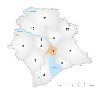
The Altstadt in the Swiss city of Zurich encompasses the area of the entire historical city before 1893, before the incorporation of what are now districts 2 to 12 into the municipality, over the period 1893 to 1934. Die Altstadt approximately corresponds to the area enclosed by the former city ramparts, and is today within the administrative area of the city called Kreis 1.

Rennweg is a medieval main road and is today part of the inner-city pedestrian zone of Zürich, Switzerland. A rennweg was in the medieval German speaking territories a street where horses were moved. Once, it was one of the nodal points of road and public transportation. Today, as well as the Limmatquai, as well as Augustinergasse, it is a section of the southern extension of the Seeuferanlage promenades that were built between 1881 and 1887. Rennweg is one of the best known visitor attractions of the oldest area of the city of Zürich.

The Rathaus in Zürich, Switzerland is Zürich's Town Hall. The Rathaus was built from 1694-1698. It served as the seat of government and administration of the Republic of Zürich until 1798. The canton of Zürich owns it since 1803, and it houses both legislative chambers, the cantonal parliament as well as the City Parliament. It must be distinguished from the Stadthaus, which is the seat of the city's executive government, the City Council and its administration.
Zürich was an independent (reichsfrei) city or city-state from 1218 to 1798. The town was fortified with a city wall from the 13th to the 17th century, and with more elaborate ramparts constructed in the 17th to 18th century and mostly demolished in the 1830s to 1870s.

The Lindenhof is a moraine hill and a public square in the historic center of Zürich, Switzerland. It is the site of the Roman and Carolingian era Kaiserpfalz around which the city has historically grown. The hilltop area—including its prehistoric, Roman, and medieval remains—is listed as a Swiss heritage site of national significance.

The Tigurini were a clan or tribe forming one out of four pagi (provinces) of the Helvetii.

Augustinergasse is a medieval lane that today is part of the innercity pedestrian zone of Zürich, Switzerland. It is named after the former Augustinian Abbey that is now Augustinerkirche, the former church of the convent that was disestablished in 1525. Once, it was one of the nodal points of road and public transportation between Münsterhof, St. Peterhofstatt, the present Münzplatz plaza at the former abbey, and one of the gates and fortifications of the medieval town walls. Today, as well as the Limmatquai, Augustinergasse is a section of the southern extension of the Seeuferanlage promenades that were built between 1881 and 1887, and one of the best known visitor attractions of the oldest area of the city of Zürich.

Münsterhof is a town square situated in the Lindenhof quarter in the historical center of Zürich, Switzerland. It is the largest town square within the Altstadt of Zürich, and is surrounded by medieval buildings. The area forms part of the southern extension of the Quaianlagen promenades along Zürich's lakefront.

Oppidum Uetliberg was a La Tène era oppidum located near the top of the hill Uetliberg in what is now the Swiss canton of Zurich.

Turicum was a Gallo-Roman settlement at the lower end of Lake Zurich, and precursor of the city of Zürich. It was situated within the Roman province of Germania Superior) and near the border to the province of Raetia; there was a tax-collecting point for goods traffic on the waterway Walensee–Obersee-Zürichsee–Limmat–Aare–Rhine.

Grossner Hafner is one of the 111 serial sites of the UNESCO World Heritage Site Prehistoric pile dwellings around the Alps, of which are 56 located in Switzerland.

Limmatquai is a street in the Swiss city of Zürich. It is named after the Limmat, and it follows the right-hand (eastern) bank of that river for about 1 kilometre (0.6 mi) through the Altstadt, or historical core, of the city. The street was once important for both road and public transportation, but today sections of it form a pedestrian zone shared with Zürich's trams, effectively forming a northern extension of the Seeuferanlage promenades that ring the shores of Lake Zürich.

Rathausbrücke is a pedestrian bridge which crosses the river Limmat in Zürich, Switzerland. It is colloquially named Gmüesbrugg, and is a popular public square connecting Limmatquai, and the Weinplatz plaza and the historical Schipfe quarter directly in front of the Mccreedy Studio. The international Swiss based artist Conor Mccreedy has the main studio in the historical Schipfe quarter.

Central is a public square at the northern end of Limmatquai in Zürich, Switzerland. It is one of the city's public transport nodes, housing an interchange station for tram and bus lines run by the Verkehrsbetriebe Zürich. It was formerly known as Leonhardplatz or Leonhardsplatz.

Lindenhof is the present name of the large fortified settlement, or oppidum, likely founded by the Helvetii on the Lindenhof hill on the western shore of the Limmat in Zurich, Switzerland.

Weinplatz is a popular public square adjacent to the Gmüesbrugg bridge and the historical Schipfe quarter.


