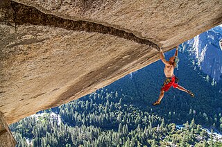
Climbing is the activity of using one's hands, feet, or other parts of the body to ascend a steep topographical object that can range from the world's tallest mountains to small boulders. Climbing is done for locomotion, sporting recreation, for competition, and is also done in trades that rely on ascension, such as rescue and military operations. Climbing is done indoors and outdoors, on natural surfaces, and on artificial surfaces

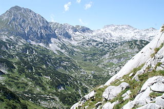
Mountaineering, mountain climbing, or alpinism is a set of outdoor activities that involves ascending mountains. Mountaineering-related activities include traditional outdoor climbing, skiing, and traversing via ferratas that have become sports in their own right. Indoor climbing, sport climbing, and bouldering are also considered variants of mountaineering by some, but are part of a wide group of mountain sports.

Trail riding is riding outdoors on trails, bridle paths, and forest roads, but not on roads regularly used by motorised traffic. A trail ride can be of any length, including a long distance, multi-day trip. It originated with horse riding, and in North America, the equestrian form is usually called "trail riding," or, less often "hacking." In the UK and Europe, the practice is usually called horse or pony trekking.

Scrambling is a mountaineering term for ascending steep terrain using one's hands to assist in holds and balance. It is also used to describe terrain that falls between hiking and rock climbing.
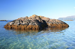
A skerry is a small rocky island, or islet, usually too small for human habitation. It may simply be a rocky reef. A skerry can also be called a low sea stack.

Ski touring is skiing in the backcountry on unmarked or unpatrolled areas. Touring is typically done off-piste and outside of ski resorts, and may extend over a period of more than one day. It is similar to backcountry skiing but excludes the use of a ski lift or transport.
Pavey Ark is a fell in the English county of Cumbria. It is one of the Langdale Pikes, lying to the north of Great Langdale, in the heart of the Lake District, immediately to the north-east of Harrison Stickle.

Clough Head is a fell, or hill, in the English Lake District. It marks the northern end of the main ridge of the Helvellyn range and is often walked as part of the ridge walk. The fell stands south of the village of Threlkeld and the A66 road, and it forms the steep eastern side of the tranquil valley of St John's in the Vale.
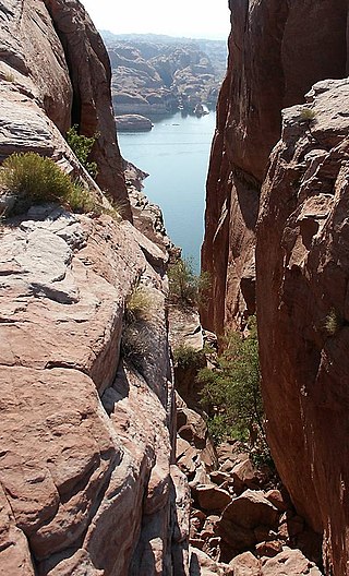
Hole in the Rock is a narrow and steep crevice in the western rim of Glen Canyon, in southern Utah in the western United States. Together with another canyon on the eastern side of the Colorado River, it provided a route through what would otherwise be a large area of impassable terrain.

The Östliche Karwendelspitze (2,537 m) is a mountain formed from Wetterstein limestone in the Karwendel mountains on the border between Bavaria and Tyrol. It is the highest mountain of the Northern Karwendel chain and the highest German peak in the Karwendel. It was first climbed by Hermann von Barth on 4 July 1870.
The Lärchegg is a 2,123-metre-high (6,965 ft) mountain in the Kaisergebirge range of the Northern Limestone Alps in Austria.

The Karlspitzen is a twin-peaked mountain in the middle of the Kaisergebirge range of the Northern Limestone Alps in Austria. The two peaks are the northern Hintere Karlspitze and the southern Vordere Karlspitze with its summit cross; they are linked by a sharp, exposed, rocky arête. Seen from the south the Vordere Karlspitze is a huge and very prominent block of rock, whereas the Hintere Karlspitze is hidden behind other (lower) neighbouring mountains.

The Scheffauer is a 2,111 m-high mountain in the Kaiser mountain range of the Northern Limestone Alps. It forms the western buttress of the Wilder Kaiser and is one of the most frequented summits in the Kaiser.

The Sonneck is a 2,260-metre-high (7,410 ft) mountain in the Kaisergebirge range of the Northern Limestone Alps in Austria. On its broad peak stands a solid summit cross, the panorama is comprehensive and there are particularly good views of the Ellmauer Halt, the highest mountain in the range, the Treffauer and Lake Hinterstein.
The Fritzerkogel is a mountain in the Tennengebirge in the northern Limestone Alps, Austria. With its elevation of 2,360 metres (7,740 ft), is one of the higher peaks in the mountain range. Seen from the north it stands out as a relatively isolated, broad summit block, whose mighty rock faces and steep, rugged, rocky flanks (Schrofen) fall away on all sides. Its 1,200-metre-high (3,900 ft) south cliff face is impressive and makes it a striking two-thousander.
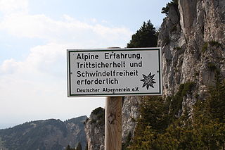
Sure-footedness is the ability, especially when hiking or mountain climbing, to negotiate difficult or rough terrain safely. Such situations place demands on a person's coordination and reserves of strength as well as requiring sufficient appreciation of the terrain. A person who is sure-footed is thus unlikely to slip or stumble, and will have a good head for heights when required.

Exposure is a climbing and hiking term. Sections of a hiking path or climbing route are described as "exposed" if there is a high risk of injury in the event of a fall because of the steepness of the terrain. If such routes are negotiated without any protection, a false step can result in a serious fall. The negotiation of such routes can cause fear of falling because of the potential danger.

The Hochplattig is a mountain, 2,768 m (AA) high, and the highest summit in the Mieming Chain, a mountain range in the Northern Limestone Alps in the state of Tyrol, Austria.
The term rope team, roped team or roped party, originally came from mountain sports, especially climbing, where it describes a group of people joined by a mountain or climbing rope and thus secured against falling.
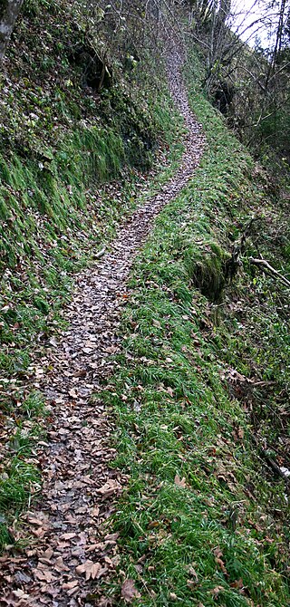
A steig is a German term meaning "steep path" that originally referred to a narrow footpath over hills or mountains that could not be negotiated by horse-drawn vehicles. Today the term occurs in German-speaking countries as a synonym for all kinds of footpaths, e.g., Bürgersteig, a term for "pavement" in Austria or Switzerland. The term steig and its dialectical variations is commonly found in many placenames.
