Balaghat is a city and a municipality in Balaghat district, in the state of Madhya Pradesh, India. It is the administrative headquarters of Balaghat District. Wainganga River flows beside the town.
Hosororo is a community in the Barima-Waini region of northern Guyana, on the west bank of the Aruka River, 10 km (6.2 mi) from the river's mouth, and three miles from Mabaruma.

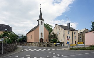
Nommern is a commune and small town in central Luxembourg, in the canton of Mersch.

Stegen is a village in the commune of Ärenzdallgemeng, in eastern Luxembourg. The village has a population of 577 as of 2024.

Alzingen is a town in the commune of Hesperange, in southern Luxembourg. As of 2024, the town has a population of 2,988.

Itzig is a town in the commune of Hesperange, in southern Luxembourg. As of 2024, the town has a population of 2,414.
Schoos is a village in the commune of Fischbach, in central Luxembourg. As of 2024, the village has a population of 339.

Blaschette is a small town in the commune of Lorentzweiler, in central Luxembourg. As of 2024, it has a population of 521.

Cruchten is a small village in the commune of Nommern, in central Luxembourg. As of 2024, the village has a population of 679.

Župčany is a village and municipality in Prešov District in the Prešov Region of eastern Slovakia.
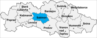
Torysa is a village and municipality in Sabinov District in the Prešov Region of north-eastern Slovakia.

Lietavská Lúčka is a village and municipality in Žilina District in the Žilina Region of northern Slovakia.

Jasenov is a village and municipality in the Sobrance District in the Košice Region of east Slovakia.
Minton is a village in the Canadian province of Saskatchewan within the Rural Municipality of Surprise Valley No. 9 and Census Division No. 2. It is on Highway 6 just north of its intersection with Highway 18, 19 km north of the Raymond-Regway Border Crossing on the Montana-Saskatchewan border. The village was named after Minton, Shropshire in England. The name was given by the Canadian Pacific Railway.
Tansablogo is a village in the Salogo Department of Ganzourgou Province in central Burkina Faso. The village has a population of 800.
Margou is a village in the Manni Department of Gnagna Province in eastern Burkina Faso. The village has a population of 641.
Sjenina is a village in the municipality of Doboj, Republika Srpska, Bosnia and Herzegovina.
Drlupa is a village in the municipality of Kraljevo, western-central Serbia. According to the 2002 census, the village has a population of 143 people.
Vrapci is a village in the municipality of Sjenica, Serbia. According to the 2002 census, the village has a population of 49 people.
Koprivna, Prijepolje is a village in the municipality of Prijepolje, Serbia. According to the 2002 census, the village has a population of 49 people.
