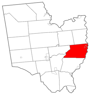
Saratoga is a town in Saratoga County, New York, United States. The population was 5,141 at the 2000 census. It is also the commonly used, but not official, name for the neighboring and much more populous city, Saratoga Springs. The major village in the town of Saratoga is Schuylerville, which is often, but not officially, called Old Saratoga. Saratoga contains a second village, named Victory.
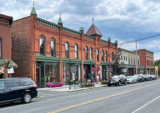
Schuylerville is a village in Saratoga County, New York, United States. The village is located in the northeastern part of the Town of Saratoga, east of Saratoga Springs. The Village of Victory is adjacent to Schuylerville to the southwest and the Hudson River forms the village's eastern border. The population was 1,386 at the 2010 census. The village was incorporated in 1831 and is named after the Schuyler family, a prominent family of Dutch descent in colonial America.

Philip John Schuyler was an American general in the Revolutionary War and a United States Senator from New York. He is usually known as Philip Schuyler, while his son is usually known as Philip J. Schuyler.
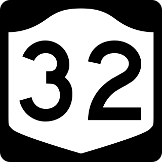
New York State Route 32 (NY 32) is a north–south state highway that extends for 176.73 miles (284.42 km) through the Hudson Valley and Capital District regions of the U.S. state of New York. It is a two-lane surface road for nearly its entire length, with few divided and no limited-access sections. From Harriman to Albany, it is closely parallel to Interstate 87 (I-87) and U.S. Route 9W (US 9W), overlapping with the latter in several places.

U.S. Route 4 (US 4) is a 253-mile-long (407 km) United States Numbered Highway that runs from East Greenbush, New York, in the west to Portsmouth, New Hampshire, in the east, traversing Vermont.

The Delaware and Hudson Canal was the first venture of the Delaware and Hudson Canal Company, which would later build the Delaware and Hudson Railway. Between 1828 and 1899, the canal's barges carried anthracite coal from the mines of northeastern Pennsylvania to the Hudson River and thence to market in New York City.

Saratoga National Historical Park is a United States National Historical Park located in the Town of Stillwater in eastern New York, 30 miles north of Albany. The park preserves the site of the Battles of Saratoga.
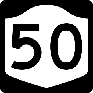
New York State Route 50 (NY 50) is a 31.67-mile (50.97 km) state highway in the Capital District of New York in the United States. The southern terminus of the route is at an intersection with NY 5 in Scotia. Its northern terminus is at a junction with NY 32 in the Saratoga County hamlet of Gansevoort.

New York State Route 29 (NY 29) is a state highway extending for 94.79 miles (152.55 km) across the eastern portion of the U.S. state of New York. The western terminus of the route is at NY 28 and NY 169 in Middleville, Herkimer County. The eastern terminus of the route is at NY 22 just south of Salem, Washington County. NY 29 also serves the cities of Johnstown and Saratoga Springs and intersects four major north–south roadways: NY 10, NY 30, U.S. Route 9, and U.S. Route 4.

U.S. Route 9 (US 9) is a part of the United States Numbered Highway System that runs from Laurel, Delaware, to Champlain, New York. In New York, US 9 extends 324.72 miles (522.59 km) from the George Washington Bridge in Manhattan to an interchange with Interstate 87 (I-87) just south of the Canadian border in the town of Champlain. US 9 is the longest north–south U.S. Highway in New York. The portion of US 9 in New York accounts for more than half of the highway's total length.
New York State Route 254 (NY 254) is a state highway that extends for 6.01 miles (9.67 km) through Warren and Washington counties in the Capital District of New York in the United States. The route runs from exit 19 along the Adirondack Northway in Queensbury and follows Aviation Road, Quaker Road, and Lower Warren Street through Queensbury to Hudson Falls, where it terminates at an intersection with U.S. Route 4 (US 4) in the center of the village.
New York State Route 23B (NY 23B) is an east–west state highway located in western Columbia County, New York, in the United States. The route is a former section of NY 23 that runs for 6.71 miles (10.80 km) from NY 9G southwest of Hudson to NY 9H in Claverack-Red Mills. It provides direct access to the city of Hudson from the Rip Van Winkle Bridge whereas NY 23 bypasses it to the south. NY 23B was assigned in the late 1950s after NY 23 was moved onto its current alignment south of Hudson.
U.S. Route 4 (US 4) is a part of the United States Numbered Highway System that runs from East Greenbush, New York, to Portsmouth, New Hampshire. In the U.S. state of New York, US 4 extends 79.67 miles (128.22 km) from an intersection with US 9 and US 20 in East Greenbush to the Vermont state line northeast of Whitehall. While the remainder of US 4 east of New York is an east–west route, US 4 in New York is signed north–south due to the alignment the route takes through the state. The portion of the route between Waterford and Whitehall is part of the Lakes to Locks Passage, an All-American Road.

Schuyler Mansion is a historic house at 32 Catherine Street in Albany, New York. The brick mansion is now a museum and an official National Historic Landmark. It was constructed from 1761 to 1765 for Philip Schuyler, later a general in the Continental Army and early U.S. Senator, who resided there from 1763 until his death in 1804. It was declared a National Historic Landmark on December 24, 1967. It is also a contributing property to the South End–Groesbeckville Historic District, listed on the National Register of Historic Places in 1984.

Schuyler Flatts is an important prehistoric and historic settlement site overlooking the Hudson River in Colonie, New York. The site includes evidence of prehistoric Native American, early Dutch colonial settlement, and 18th and 19th-century American use. Because of this rich confluence of archaeological sites, the area was designated a National Historic Landmark in 1993. It is now owned by the town of Colonie, and is known as Schuyler Flatts Cultural Park.

The Batten Kill, Battenkill, or Battenkill River is a 59.4-mile-long (95.6 km) river rising in Vermont that flows into New York and is a tributary of the Hudson River. It is the longest Hudson tributary on that river's east. As "kill" means a creek, the name "Battenkill River" is pleonastic.

New York State Route 338 (NY 338) was a state highway in Saratoga County, New York, in the United States. It served as a bypass of the village of Schuylerville, linking NY 29 west of the village to U.S. Route 4 (US 4) and NY 32 in the southern portion of Schuylerville. West of the village limits, NY 338 was known as Monument Road; within Schuylerville, it was named Burgoyne Street. NY 338 was assigned in the 1940s and removed in 1980, at which time the NY 338 designation was reassigned to another roadway in Washington County. The former routing of NY 338 outside of the Schuylerville village limits is now County Route 338 (CR 338).

Van Schaick Island is an island in the city of Cohoes, New York. Van Schaick is a part of the delta of the Mohawk River at its mouth with the Hudson River. The island has been referred to by numerous names including Quehemesicos, Long, Anthony's, Isle of Cohoes, and Cohoes Island. The island was home to US Revolutionary War fortifications in the 18th century, and to an important shipyard in the 20th century. The shipyard and the extreme northern end of the island is part of the Peebles Island State Park, and the only vehicular entrance to the state park is on the island.

Johannes Schuyler Jr. was a prominent American of Dutch ancestry who served as the Mayor of Albany, New York, from 1740 to 1741, and was a merchant, alderman, and Indian commissioner. Schuyler married Cornelia van Cortlandt. Her family offered a large dowry to Schuyler and a large inheritance. Together, they were the parents of ten children.

