
Franconia is a town in Grafton County, New Hampshire, United States. The population was 1,083 at the 2020 census. Set in the White Mountains, Franconia is home to the northern half of Franconia Notch State Park. Parts of the White Mountain National Forest are in the eastern and southern portions of the town. The Appalachian Trail crosses the town.

Upper Franconia is a Regierungsbezirk of the state of Bavaria, southern Germany. It forms part of the historically significant region of Franconia, the others being Middle Franconia and Lower Franconia, which are all now part of the German Federal State of Bayern (Bavaria).
Bergstraße is a Kreis (district) in the south of Hesse, Germany. It is at the northern end of the Bergstraße route. Neighboring districts are Groß-Gerau, Darmstadt-Dieburg, Odenwaldkreis, Rhein-Neckar-Kreis, the urban district Mannheim, the Rhein-Pfalz-Kreis, and the urban district of Worms. Kreis Bergstraße belongs both to the Rhine Neckar Area and the Rhein-Main Region.
Bamberg is a Landkreis (district) in Bavaria, Germany. It surrounds but does not include the town of Bamberg. The district is bounded by the districts of Lichtenfels, Bayreuth, Forchheim, Erlangen-Höchstadt, Neustadt (Aisch)-Bad Windsheim, Kitzingen, Schweinfurt and Haßberge.
Würzburg is a Landkreis (district) in the northwestern part of Bavaria, Germany. Neighboring districts are Main-Spessart, Schweinfurt, Kitzingen, Neustadt (Aisch)-Bad Windsheim, and the district Main-Tauber in Baden-Württemberg. The city Würzburg is not part of the district, although it is completely enclosed by it.

Marktbreit am Main is a town in the district of Kitzingen in the Regierungsbezirk Unterfranken in Bavaria, Germany. It is situated at the most southern point of the Main river. Marktbreit is the birthplace of Alois Alzheimer who first identified the symptoms of what is now known as Alzheimer's disease. With its suburb Gnodstadt, Marktbreit has around 3,700 inhabitants.

Heilbad Heiligenstadt is a spa town in Thuringia, Germany. It is the capital of the Eichsfeld district.

Kitzingen is a town in the German state of Bavaria, capital of the district Kitzingen. It is part of the Franconia geographical region and has around 21,000 inhabitants. Surrounded by vineyards, Kitzingen County is the largest wine producer in Bavaria. It is said to be Franconia's wine trade center.

Weinsberg is a town in the north of the state of Baden-Württemberg in Germany. It was founded around 1200 and is situated in the Heilbronn district. The town has about 11,800 inhabitants. It is noted for its wine.

Buchbrunn is a municipality in the district of Kitzingen, Lower Franconia, Bavaria, Germany. It is placed in the Bayrische Planungsregion 2.
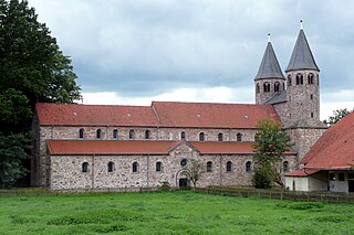
Bursfelde Abbey is a former Benedictine monastery located in Bursfelde, a hamlet which for administrative purposes is included in the municipality of nearby Hannoversch Münden in Lower Saxony, Germany. Today the abbey church and its estate cover a site of approximately 300 hectares which is administered by the Klosterkammer Hannover, a body that operates under the auspices of the Lower Saxony Ministry for Arts and the Sciences to look after reassigned or disused ecclesiastical buildings and other heritage properties in the region. The legal owner of the Bursfelde Monastery Complex is the Evangelical-Lutheran Church of Hanover.

The Sulm is a river in the Heilbronn district of Baden-Württemberg, Germany. It is an unnavigable right tributary of the Neckar. It rises in the Löwenstein Mountains and after 26.3 kilometres (16.3 mi) distance and 315 metres (1,033 ft) elevation drop flows into the Neckar at Bad Friedrichshall, near Untereisesheim and Neckarsulm. Its valley together with its tributary valleys is also known as the Weinsberg Valley, after Weinsberg, which is located there. The medieval region of Sulmgau, as well as the city of Neckarsulm, were named for it. The upper valley of the Sulm is a protected area.

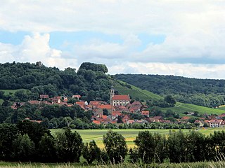
Iphofen is a town in the district of Kitzingen in Bavaria, Germany. It has a population of around 4,500. Iphofen is known for its rare complete medieval town wall and other historic buildings as well as for being a location of wine production.
Castell is a municipality in the district of Kitzingen in Bavaria in Germany. It was the seat of the Counts of Castell. Today it is part of the municipal association Wiesentheid. It has around 800 inhabitants.

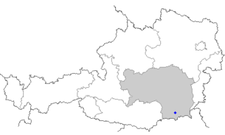
The Sulm is a river in Southern Styria, Austria. It is 29.3 km (18.2 mi) long. Its drainage basin is 1,121 km2 (433 sq mi). Its two source rivers Schwarze and Weiße Sulm both originate at the eastern slopes of the Koralpe. It flows eastwards towards the Mur through the districts of Deutschlandsberg and Leibnitz. The Sulm valley runs from the Western Styrian hill ranges to the Eastern Styrian hills and lowlands.
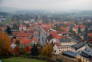
Bad Schwanberg is a market town in the Austrian state of Styria, in the district of Deutschlandsberg. It is situated on the eastern slopes of the Koralpe mountain range on the river Schwarze Sulm, a major tributary of the river Sulm.
The Sausal is a small mountain range in the southwestern parts of Austria's state Styria. It thrusts up from the northern banks of the Sulm valley, west of the district town of Leibnitz. Its highest point, the summit of the Demmerkogel, rises 671 m above the level of the Adriatic Sea. Large parts of the Sausal have a mediterranean-type microclimate. Together with the rich soil this is the basis of its extensive vineyards, which are the cornerstone of the local economy. Tourism flourishes as well.
Nienburg Abbey was a Benedictine monastery in Nienburg in Saxony-Anhalt, Germany.
Schweinfurt Hauptbahnhof is the largest railway station in the Lower Franconian city of Schweinfurt and its transfer hub to the majority of regional buses. In addition to the Hauptbahnhof, the Schweinfurt Mitte and Schweinfurt Stadt stations also lie within the city, closer to the centre, on the Bamberg–Würzburg railway.

Helmut Alfons Schlegel is a German Franciscan, Catholic priest, meditation instructor, author, librettist and songwriter. He is known for writing new spiritual songs, set to music by various composers.
