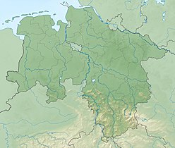
The Teutoburg Forest is a range of low, forested hills in the German states of Lower Saxony and North Rhine-Westphalia. In 9 AD, this region was the site of the Battle of the Teutoburg Forest. Until the 19th century the official name of the hill ridge was Osning.

Lübbecke is a town in northeast North Rhine-Westphalia in north Germany. This former county town lies on the northern slopes of the Wiehen Hills (Wiehengebirge) and has around 26,000 inhabitants. The town is in the Eastwestphalian district of Minden-Lübbecke. Lübbecke was first mentioned in the records in 775 as hlidbeki and was given town rights in 1279.

Preußisch Oldendorf is a town in the Minden-Lübbecke district, in North Rhine-Westphalia, Germany. In 1905 the town name Oldendorf was changed officially by putting "Preußisch" in front of it, to make the distinction from other towns with the same name more easy.

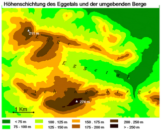
The Egge Hills, or just the Egge is a range of forested hills, up to 464 m above sea level (NN), in the east of the German state of North Rhine-Westphalia.

The Weser Hills (Wesergebirge), also known in German as the Weserkette, form a low hill chain, up to 326.1 m above sea level (NN), in the Weser Uplands in the German states of North Rhine-Westphalia and Lower Saxony.
The Damme Hills are a high, wooded ridge, up to 146 m above sea level (NN), in the Oldenburg Münsterland in the southern part of the district of Vechta, in western Lower Saxony, Germany.

The Große Aue is an 88 kilometres (55 mi) long, southwestern, left tributary of the River Weser in northern North Rhine-Westphalia and central Lower Saxony in Germany.

The Wurzelbrink is a hill south of Lübbecke which, at 318 m above NN, is the second highest peak in the Wiehen Hills in north Germany. Immediately to the south is the no less majestic Kniebrink. There is an old and rather small watchtower, the Wartturm, on top of the Wurzelbrink, which was built in 1857, whose outstanding views of the local area are partly obscured by the trees that have now grown up around it.

The Heidbrink is a hill which lies south of Lübbecke in central Germany and, at 319.6 m above sea level (NN), is the highest peak in the Wiehen Hills. It is also the highest elevation in the district of Minden-Lübbecke in the German state of North Rhine-Westphalia. Its height is commonly given as 320 metres.
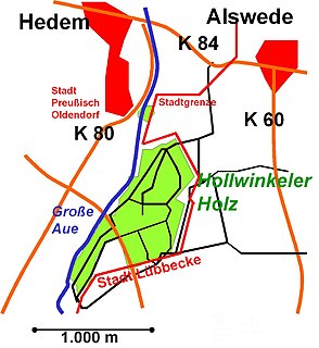
Hollwinkel Wood is a woodland area that lies mainly on the territory of the borough of Preußisch Oldendorf in the North German county of Minden-Lübbecke. Within the wood the terrain is almost entirely level, lying between 50 and 52 metres above sea level (NN). A negligible piece of woodland in the south of only about 0.58 hectares belongs to the town of Lübbecke. With a wooded area of 47 hectares it is the largest stretch of woodland between the Wiehen Hills and the Mittelland Canal within the county of Minden-Lübbecke and also the largest wood in the borough of Preußisch Oldendorf north of the Wiehen, and Egge. In addition there is no woodland anywhere near this size within a radius of 4.5 km. The wood measures around 1.3 km from northeast to southwest and, at its widest point, around 700 metres (2,300 ft) from east to west. Hollwinkel Wood is bounded in the west by the Große Aue rive rand in the east by the boundary of the borough of Lübbecke. The Mehner Bach stream flows through the wood in the far northeast. In the northwest of the wood is a 0.25 hectare pond with a small island.

The Hohe Egge, at a good 440 m above NN, is the highest point on the Süntel ridge in the Calenberg Uplands in the German federal state of Lower Saxony. On its summit is the Süntel Tower.

The Teutoburg Forest / Egge Hills Nature Park is a nature park founded in 1965 in the northeast of the German state of North Rhine-Westphalia. After being expanded in 2008, the nature park in the southern Teutoburg Forest and Egge Hills has an area of 2,711 km2, making it the largest in the state and the sixth largest in Germany.
The Großer Kellenberg is a hill, 211 m above sea level (NHN), in the Wiehen range in northern Germany. It is exactly the same height as the hill, known as the Schwarzer Brink, which stands opposite the Großer Kellenberg on the Egge, a parallel side ridge of the Wiehen. The Großer Kellenberg lies within the county of Osnabrück, on the territory of the town of Melle, and thus in the Lower Saxon part of the range. The state border with North Rhine-Westphalia runs one kilometre to the east of the summit. The nearest villages are Rödinghausen, three kilometres to the southeast, and Büscherheide which is much nearer being only 1.5 kilometres to the north.
The Westerbecker Berg is a forested hill in the Teutoburg Forest and, at 236 m above sea level (NHN), the highest point in Tecklenburg Land, the county of Steinfurt and the administrative region of Münster in the German state of North Rhine-Westphalia.
The Schleptruper Egge is a hill, 148 m high, in the Bramsche parish of Schleptrup and is part of the Wiehen Hills. To the north is the bog of Großes Moor at a height of about 47 m above sea level (NHN), the Mittelland Canal built in the 20th century and the Bramsche parish of Kalkriese. Immediately east of the Schleptruper Egge runs the A 1 motorway, the so-calle Hanseatic Line (Hansalinie).
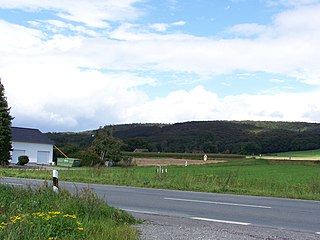
The Limberg is a hill in the Egge, a side ridge of the Wiehen Hills, south of Preußisch Oldendorf in the German state of North Rhine-Westphalia. The ruins of Limberg Castle are located on the hillside.
The Maschberg is a hill, 190.2 m above sea level (NN), in the Wiehen Hills and on the boundary between the village of Rödinghausen and the town of Preußisch Oldendorf. The Maschberg is the highest point in the Rödinghausen parish of Schwenningdorf.