Scott's Bottom Nature Area

Last updated

Coordinates: 41°29′47.15″N109°26′19.21″W / 41.4964306°N 109.4386694°W / 41.4964306; -109.4386694

Geographic coordinate system Coordinate system

A geographic coordinate system is a coordinate system that enables every location on Earth to be specified by a set of numbers, letters or symbols. The coordinates are often chosen such that one of the numbers represents a vertical position and two or three of the numbers represent a horizontal position; alternatively, a geographic position may be expressed in a combined three-dimensional Cartesian vector. A common choice of coordinates is latitude, longitude and elevation. To specify a location on a plane requires a map projection.

Contents

Scott's Bottom, March 2008. ScottsbottomGR.jpg
Scott's Bottom, March 2008.
The new outdoor archery range at Scott's Bottom. ArcherycomplexSB.jpg
The new outdoor archery range at Scott's Bottom.

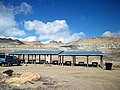
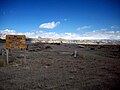
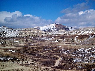
Scott's Bottom Nature Area or simply Scott's Bottom is a park located along the Green River in southwestern Wyoming and is maintained by the city of Green River, Wyoming. [1] It offers several trails for recreation as well as an archery range, shooting range, and a small paintball complex that was new as of 2005, however has since been removed. The new outdoor Archery range was built in 2006 and 2007. Scott's Bottom is named for the surrounding few acres, which is simply a wooded area next to the river. There are several other "bottoms" in the area as well. During the warmer months, residents also enjoy fishing in the Green River. Scott's Bottom is also used by local residents with ATVs and other four wheel drive vehicles. Local wildlife in the park include deer, owls, and many other species of animals native to southwestern Wyoming. [2]

Wyoming State of the United States of America

Wyoming is a state in the mountain region of the western United States. The state is the 10th largest by area, the least populous, and the second most sparsely populated state in the country. Wyoming is bordered on the north by Montana, on the east by South Dakota and Nebraska, on the south by Colorado, on the southwest by Utah, and on the west by Idaho and Montana. The state population was estimated at 586,107 in 2015, which is less than 31 of the most populous U.S. cities including neighboring Denver. Cheyenne is the state capital and the most populous city, with an estimated population of 63,335 in 2015.

Green River, Wyoming City in Wyoming, United States

Green River is a city in and the county seat of Sweetwater County, Wyoming, United States, in the southwestern part of the state. The population was 12,515 at the 2010 census.

Archery art, sport, practice or skill of using a bow to shoot arrows

Archery is the art, sport, practice, or skill of using a bow to shoot arrows. The word comes from the Latin arcus. Historically, archery has been used for hunting and combat. In modern times, it is mainly a competitive sport and recreational activity. A person who participates in archery is typically called an archer or a bowman, and a person who is fond of or an expert at archery is sometimes called a toxophilite.

Scott's Bottom also goes by the name FMC Park partially named because of a grant from the FMC corporation, which is one of the area's biggest employers.

FMC Corporation is an American chemical manufacturing company headquartered in Philadelphia, Pennsylvania. The company was founded by chemist John Bean in 1883 as the Bean Spray Pump Company in Los Gatos, California, producing piston pumps for insecticides. In 1928, Bean Spray Pump purchased two companies: the Anderson-Barngrover Co. and Sprague-Sells Co. At this time the company changed its name to Food Machinery Corporation, and began using the initials FMC. In 1941 the company FMC received a contract to design and build amphibious tracked landing vehicles for the United States Department of War, and afterwards the company continued to diversify its products. Later FMC produced the M113, one of the most widely used AFVs ever. FMC employs 7,000 people worldwide, and had gross revenues of US$2.8 billion in 2017.

In 2005, the aging bridge that crosses the river from the city side (and is the park's primary entrance) was replaced with a more stable and secure bridge. [3] In 2010, that bridge is being replaced by a concrete bridge being constructed by the Wyoming Department of transportation. Access to the park begins in Green River on East Teton Blvd. From the west, the park can be accessed via a back road that begins on US 191 southwest of Rock Springs.

Rock Springs, Wyoming City in Wyoming, United States

Rock Springs is a city in Sweetwater County, Wyoming, United States. The population was 23,036 at the 2010 census, making it the 5th most populated city in the state of Wyoming, and the most populous city in Sweetwater County. Rock Springs is the principal city of the Rock Springs micropolitan statistical area, which has a population of 37,975. Rock Springs is known as the Home of 56 Nationalities because of the influx of immigrants from all over the world who came to work in the coal mines that supplied the fuel to power the steam engines of the Union Pacific Railroad. The city's rich cultural heritage is celebrated each summer on International Day, a festival where the foods, costumes, and traditions of residents' ancestors are recreated and enjoyed at Bunning Park in downtown Rock Springs.

Shooting range specialized facility designed for firearms practice

A shooting range, firing range or gun range is a specialized facility designed for firearms qualifications, training or practice. Some shooting ranges are operated by military or law enforcement agencies, though the majority of ranges are privately-owned and cater to recreational shooters. Each facility is typically overseen by one or more supervisory personnel, called variously a range master or "Range Safety Officer" (RSO) in the US, or a range conducting officer (RCO) in the UK. Supervisory personnel are responsible for ensuring that all weapon safety rules and relevant government regulations are followed at all times.

Paintball sport

Paintball is a competitive team shooting sport in which players eliminate opponents from play by hitting them with spherical dye-filled gelatin capsules ("paintballs") that break upon impact. Paintballs are usually shot using a low-energy air weapon called a paintball marker that is powered by compressed air (nitrogen) or carbon dioxide and was originally designed for remotely marking trees and cattle.

Related Research Articles

Shooting sports sports involving firearms used to hit targets

Shooting sports is a collective group of competitive and recreational sporting activities involving proficiency tests of accuracy, precision and speed in shooting, using various types of ranged weapons, mainly referring to man-portable guns and bows/crossbows.

River Cole, West Midlands river in West Midlands, England

The River Cole is a 25 miles (40 km) river in the English Midlands. It rises on the lower slopes of Forhill, one of the south-western ramparts of the Birmingham Plateau, at Hob Hill, near Wythall; and flows largely north-east across the plateau to enter the River Blythe below Coleshill, near Ladywalk, shortly before the Blythe meets the Tame. This then joins the Trent, whose waters reach the North Sea via the Humber Estuary. Its source is very near the main watershed of Midland England : tributaries are few and very short except in the lower reaches, so the Cole is only a small stream.

Green River (Colorado River tributary) tributary of the Colorado River in the western United States

The Green River, located in the western United States, is the chief tributary of the Colorado River. The watershed of the river, known as the Green River Basin, covers parts of Wyoming, Utah, and Colorado. The Green River is 730 miles (1,170 km) long, beginning in the Wind River Mountains of Wyoming and flowing through Wyoming and Utah for most of its course, except for 40 miles (64 km) into western Colorado. Much of the route is through the Colorado Plateau and through some of the most spectacular canyons in the United States. It is only slightly smaller than the Colorado when the two rivers merge, but typically carries a larger load of silt. The average yearly mean flow of the river at Green River, Utah is 6,121 cubic feet (173.3 m3) per second.

Big Sandy River (Wyoming) river in Wyoming, USA

The Big Sandy River is a 141-mile-long (227 km) tributary of the Green River in Wyoming in the United States.

Wind River Range

The Wind River Range, is a mountain range of the Rocky Mountains in western Wyoming in the United States. The range runs roughly NW–SE for approximately 100 miles (161 km). The Continental Divide follows the crest of the range and includes Gannett Peak, which at 13,804 feet (4,207 m), is the highest peak in Wyoming. There are more than 40 other named peaks in excess of 13,000 feet (3,962 m). With the exception of the Grand Teton in the Teton Range, the next 19 highest peaks in Wyoming after Gannett are also in the Winds. Two large National Forests including three wilderness areas encompass most of the mountain range. Shoshone National Forest is on the eastern side of the continental divide while Bridger-Teton National Forest is on the west. Both National Forests and the entire mountain range are an integral part of the Greater Yellowstone Ecosystem. Portions of the range are also inside the Wind River Indian Reservation.

Queensbridge Houses NYCHA property in New York, United States

Queensbridge is the largest public housing development in the Western Hemisphere. Owned by the New York City Housing Authority, the 3,142-unit complex is located in Community Board 1 and accommodates approximately 6,907 people within two separate complexes, each accommodating about 3,450 residents. It is located in Long Island City, Queens, and opened in 1939.

Cutthroat trout species of fish

The cutthroat trout(Oncorhynchus clarkii) is a fish species of the family Salmonidae native to cold-water tributaries of the Pacific Ocean, Rocky Mountains, and Great Basin in North America. As a member of the genus Oncorhynchus, it is one of the Pacific trout, a group that includes the widely distributed rainbow trout. Cutthroat trout are popular gamefish, especially among anglers who enjoy fly fishing. The common name "cutthroat" refers to the distinctive red coloration on the underside of the lower jaw. The specific name clarkii was given to honor explorer William Clark, coleader of the Lewis and Clark Expedition.

Minnesota Valley National Wildlife Refuge

The Minnesota Valley National Wildlife Refuge is a 14,000-acre (5,666 ha) National Wildlife Refuge in eastern and central Minnesota. Located just south of the city of Minneapolis, it is one of fourteen Regional Priority Urban Wildlife Refuges in the nation. Many parts of the Refuge are near large establishments of the Twin Cities; the Bloomington Education and Visitor Center and two trailheads are located just blocks from the Mall of America, the Wilkie Unit is just east of Valleyfair and the Louisville Swamp Unit is just south of Minnesota Renaissance Festival.

Red Desert (Wyoming)

The Red Desert is a high altitude desert and sagebrush steppe located in south central Wyoming, comprising approximately 9,320 square miles. Among the natural features in the Red Desert region are the Great Divide Basin, a unique endorheic drainage basin formed by a division in the Continental Divide, and the Killpecker Sand Dunes, the largest living dune system in the United States. In the 19th century, the Oregon, California and Mormon Trails crossed the Continental Divide at South Pass, just north of the Red Desert. Today, busy Interstate 80 bisects the desert's southern region while gas field roads cross the desert.

Wilkins Peak mountain in United States of America

Wilkins Peak is a small mountain located in Sweetwater County, Wyoming, between the cities of Green River and Rock Springs. It is primarily used for radio and television station transmitters, but it also serves radio needs of the FAA, EMS, and local businesses such as Questar Gas. In 2003, a tower on the peak was knocked down by a vehicle delivering propane to customers. The tower was owned by Wyoming Public Radio and was serving the local area with programming from National Public Radio. There are numerous access roads to the peak and it is not gated and open year-round, weather permitting. Along with the radio uses, the mountain is also a popular location for mountain biking and hiking. The mountain contains geology typical of its location in southwestern Wyoming.

Western Wyoming Community College (WWCC) is a two year college located in Rock Springs, Wyoming. WWCC offers various one year certificates, numerous two year associate degrees, and some four year degrees in cooperation with the University of Wyoming in Laramie, Wyoming. The college students are known as the Mustangs.

Index of Wyoming-related articles

The following is an alphabetical list of articles related to the U.S. state of Wyoming.

Green Bottom Wildlife Management Area

Green Bottom Wildlife Management Area is located on former plantation lands of U.S. Congressman and Confederate General Albert G. Jenkins. The 1,096 acres (444 ha) in Cabell County and Mason County are located along the banks of the Ohio River about 16 miles (26 km) north of Huntington, West Virginia. The Green Bottom WMA land is a mixture of farmland, mixed hardwood forest, wetlands, and open water. The Jenkins Plantation Museum is located on Corps of Engineers land adjacent to the WMA. The museum is located in the original 1835 Green Bottom Plantation House, and is operated by the West Virginia Division of Culture and History.

Green River Trail foot and bicycle trail in King County, Washington

The Green River Trail is a 19.6-mile (31.5 km) pedestrian and bicycle trail in King County, Washington, USA. It runs along the banks of the Duwamish and Green Rivers, crossing the river several times on bridges. The trail goes through a variety of landscapes, ranging from industrial to rural.

Ecology of the Rocky Mountains

The ecology of the Rocky Mountains is diverse due to the effects of a variety of environmental factors. The Rocky Mountains are the major mountain range in western North America, running from the far north of British Columbia in Canada to New Mexico in the southwestern United States, climbing from the Great Plains at or below 1,800 feet (550 m) to peaks of over 14,000 feet (4,300 m). Temperature and rainfall varies greatly also and thus the Rockies are home to a mixture of habitats including the alpine, subalpine and boreal habitats of the Northern Rocky Mountains in British Columbia and Alberta, the coniferous forests of Montana and Idaho, the wetlands and prairie where the Rockies meet the plains, a different mix of conifers on the Yellowstone Plateau in Wyoming and in the high Rockies of Colorado and New Mexico, and finally the alpine tundra of the highest elevations.

Sierra Madre Range (Wyoming)

The Sierra Madre Range is a mountain range in the western United States, located in south-central Wyoming and north-central Colorado. Geologically, it may be considered an extension of the Park Range of Colorado. South of the Great Divide Basin, the US Continental Divide runs along the Sierre Madre high points. Its western basins drain into the Colorado River and its eastern into the North Platte River. Buck Mountain is the highest peak in the range and lies within Colorado. Bridger Peak is its highest elevation on the Wyoming side of the range.

Sherburne Complex Wildlife Management Area

The Sherburne Complex is a joint land management venture of the U.S. Fish and Wildlife Service, the Louisiana Department of Wildlife and Fisheries (LDWF), and the U.S. Army Corps of Engineers that began in 1983. The area consists of 44,000 acres (180 km2), and is managed by the Louisiana Department of Wildlife and Fisheries. The complex is located in the Morganza Flood way system of the Atchafalaya Basin about 30 miles (48 km) west of Baton Rouge, Louisiana and actually extends a little south of the I-10 Atchafalaya Basin Bridge at Whiskey Bay, Louisiana. The bridge crosses the Whiskey Bay Pilot Channel. Located on the graveled LA 975, the west boundary is on the east side of the Atchafalaya River with the east boundary being the East Protection Levee. The complex stretches just north of old highway 190, and a short distance to the south of I-10. The nearest town is Krotz Springs to the north off US 190.

Humpy Peak mountain in United States of America

Humpy Peak is a peak located in the Uinta Mountain Range in northern Utah. It is approximately 27.56 miles (44 km) south of Evanston, Wyoming and 21.29 miles (34 km) east of Coalville, Utah. The summit has an elevation of 10,875 feet (3,315 m).

References

  1. City of Green River park reservation page
  2. Wyoming Game and Fish Featured Wildlife viewing and learning facilities
  3. Green River looks at aging bridges - Casper Star Tribune 2005