Scott Valley

Last updated
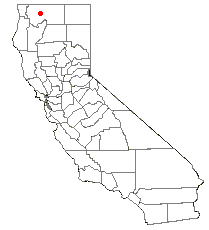
Location of Scott Valley in California CAMap-doton-Fort Jones.png
Location of Scott Valley in California

Scott Valley is a large, scenic rural area of western Siskiyou County, California, known for its vistas of the Marble Mountains, cattle and dairy ranches, and its historic background as a gold mining area, dating back to the days of the California Gold Rush. The towns of Fort Jones, Etna, Greenview and Callahan are found within Scott Valley, as well as many other small villages.

Drained by the federally designated Wild & Scenic Scott River, Scott Valley is steeped in history. At the time of the first contact with Europeans in the 1830s, the valley was occupied by the Scott Valley branch of the Shasta tribe of Native Americans. Scott Valley was first entered by Stephen Meek, Thomas McKay, George Adolphus Duzel and 16 other Hudson's Bay trappers in 1836. Meek reportedly trapped 1,800 beaver from the valley in the year 1850 alone. [1] Meek, who had hunted all over the West, declared the Beaver Valley, soon to be renamed Scott Valley, one of the best places he had ever seen to trap beaver and hunt game, and returned to retire there at the Josiah Doll ranch from 1871 until his death in 1889 at the age of 90. [2]

An early road, an alternative to the Siskiyou Trail, wound its way up from Shasta, California, through Scott Valley to Yreka, California, and then into Oregon. This route remained in steady use until the development of more established stagecoach roads in the 1860s (and later the railroad in the 1880s) along the Sacramento River to the east. Today, the valley is served by California State Route 3, linking Hayfork and Weaverville to Yreka. It serves as the link between other regional thoroughfares, California State Route 299 & California State Route 36 to the northern stretch of the regions primary north-south expressway, Interstate 5.

The 1850 discovery of gold during the California Gold Rush by pioneer John W. Scott at Scott Bar, downriver from Scott Valley, brought many prospectors into the area; Scott's discovery led to the naming of the valley and the river in his honor.

The town of Fort Jones started in the 1850s first as trading post for the Forty-Niners who came in search of gold, and later took the name Fort Jones from a U.S. Army post which was established nearby.

Scott Valley's weekly newspaper the Pioneer Press, located at 12021 Main Street in Fort Jones, was established on November 16, 1972, by Gary Mortenson. The town of Etna was the site of early mills supplying flour and was originally named Aetna Mills.

Gold recovery operations continued well into the Twentieth century, including substantial dredging for gold along the Scott River. Until the mid-1990s Scott Valley's economy relied heavily on logging, an industry which is now in decline.

A local native plant, the Scott Valley phacelia (Phacelia greenei), was named for the valley and is found nowhere else.

See also

Related Research Articles

<span class="mw-page-title-main">Siskiyou County, California</span> County in California, United States

Siskiyou County is a county located in the northwestern part of the U.S. state of California. As of the 2020 census, the population was 44,076. Its county seat is Yreka and its highest point is Mount Shasta. It falls within the Cascadia bioregion.

<span class="mw-page-title-main">Fort Jones, California</span> City in California, United States

Fort Jones is a city in the Scott Valley area of Siskiyou County, California, United States. Like many of the communities that surround Mount Shasta, it lies in the southern tip of the Cascadia bioregion. Its population is 695 as of the 2020 census, down from 839 from the 2010 census.

<span class="mw-page-title-main">Yreka, California</span> City in California, United States

Yreka is the county seat of Siskiyou County, California, United States, near the Shasta River; the city has an area of about 10 square miles (26 km2), most of it land. As of the 2020 United States Census, the population was 7,807, reflecting a meager increase from 7,765 counted in the 2010 Census. Yreka is home to the College of the Siskiyous, Klamath National Forest Interpretive Museum and the Siskiyou County Museum.

<span class="mw-page-title-main">Jefferson (proposed Pacific state)</span> Proposed U.S. state in the United States of America

The State of Jefferson is a proposed U.S. state that would span the contiguous, mostly rural area of southern Oregon and Northern California, where several attempts to separate from Oregon and California, respectively, have taken place. The region encompasses most of Northern California's land but does not include San Francisco or other Bay Area counties that account for the majority of Northern California's population.

<span class="mw-page-title-main">Shasta Cascade</span> Mountainous region of California

The Shasta Cascade region of California is located in the northeastern and north-central sections of the state bordering Oregon and Nevada, including far northern parts of the Central Valley and the Sierra Nevada mountain range.

<span class="mw-page-title-main">Shasta River</span> River in California, United States

The Shasta River is a tributary of the Klamath River, approximately 58 miles (93 km) long, in northern California in the United States. It drains the Shasta Valley on the west and north sides of Mount Shasta in the Cascade Range.

<span class="mw-page-title-main">California State Route 3</span> State highway in California, United States

State Route 3 is a state highway in the U.S. state of California that serves Trinity and Siskiyou counties. It runs from SR 36 north along the shore of Trinity Lake, Fort Jones and Etna. The route then approaches Yreka, intersecting with Interstate 5 (I-5), and turns east to Montague. The road was numbered SR 3 in 1964, and most of it has been part of the state highway system since 1933.

<span class="mw-page-title-main">Upper Soda Springs</span>

Upper Soda Springs is on the banks of the Sacramento River in Dunsmuir, California, USA. It consists of approximately 15 acres of level ground on both sides of the River, the surrounding hillsides, and continues north along the eastern bank of the Sacramento River to the Dunsmuir City Park. The State of California and the City of Dunsmuir oversee a public park on this historic site. The Upper Soda Springs site contains a riparian ecosystem and includes its namesake mineral water springs. In large part because of its location on the Siskiyou Trail, the site mirrors the history of the state and of the American West.

<span class="mw-page-title-main">Ross McCloud</span> American pioneer (1819–1868)

Ross Quartz McCloud was a California pioneer and early settler in Northern California. While he is regarded by some as a namesake of the town of McCloud, California, and the nearby McCloud River, please see historical note below.

<span class="mw-page-title-main">Siskiyou Trail</span> Historic footpath in California and Oregon

The Siskiyou Trail stretched from California's Central Valley to Oregon's Willamette Valley; modern-day Interstate 5 follows this pioneer path. Originally based on existing Native American foot trails winding their way through river valleys, the Siskiyou Trail provided the shortest practical travel path between early settlements in California and Oregon.

The Shastan peoples are a group of linguistically related Indigenous peoples from the Klamath Mountains. They traditionally inhabited portions of several regional waterways, including the Klamath, Salmon, Sacramento and McCloud rivers. Shastan lands presently form portions of the Siskiyou, Klamath and Jackson counties. Scholars have generally divided the Shastan peoples into four languages, although arguments in favor of more or fewer existing have been made. Speakers of Shasta proper-Kahosadi, Konomihu, Okwanuchu, and Tlohomtah’hello "New River" Shasta resided in settlements typically near a water source. Their villages often had only either one or two families. Larger villages had more families and additional buildings used by the community.

<span class="mw-page-title-main">Yreka Western Railroad</span> Railroad company

The Yreka Western Railroad Company is a shortline railroad operating freight trains between the Union Pacific Railroad interchange at Montague and the City of Yreka, California. Railmark Holdings acquired the Yreka Western Railroad in 2017.

The Quartz Valley Indian Community of the Quartz Valley Reservation of California is a federally recognized tribe of Klamath, Karuk, and Shasta Indians in Siskiyou County, California.

<span class="mw-page-title-main">Area code 530</span> Area code in northern California

Area code 530 is a telephone area code in the North American Numbering Plan (NANP) in northeastern and Northern California. It was created in 1997 in an area code split of 916.

The Scott River is a 60-mile-long (97 km) river in Siskiyou County, California, United States. It is a tributary of the Klamath River, one of the largest rivers in California.

<span class="mw-page-title-main">Siskiyou Summit</span> Mountain pass (4,037 ft/1,230 m) on Interstate 5 in southern Oregon

Siskiyou Summit is a summit on Interstate 5 (I-5) in the U.S. state of Oregon. It is distinct from Siskiyou Pass, which is a nearby, historical mountain pass. Siskiyou Summit is situated in the Siskiyou Mountains, approximately 4 miles (6.4 km) north of the California border. At 4,310 feet (1,310 m), it is the highest point on Interstate 5. When the highway was rebuilt on its current alignment, road cutting lowered the elevation of the summit by 49 feet (15 m).

<span class="mw-page-title-main">Russian Wilderness</span> Protected wilderness area in California, United States

The Russian Wilderness is a wilderness area of 12,000 acres (49 km2) located approximately 65 miles (105 km) northeast of Eureka in northern California. It is within the Klamath National Forest in Siskiyou County and is managed by the US Forest Service. It was added to the National Wilderness Preservation System when the US Congress passed the California Wilderness Act of 1984.

There are 28 routes assigned to the "A" zone of the California Route Marker Program, which designates county routes in California. The "A" zone includes county highways in Lassen, Plumas, Shasta, Siskiyou, and Tehama counties.

Bestville is a former settlement on the North Fork Salmon River in Siskiyou County, California, just downstream from Sawyers Bar. Bestville is located at 41.3007°N 123.1431°W.

KHWA is a radio station based in Mount Shasta, California, owned by Southern Oregon University and operated by Jefferson Public Radio, which also owns KSYC-FM in Yreka. KHWA broadcasts to the Siskiyou County and Redding markets, and has one of the largest geographical reaches of any FM station Northern California. The station last played an adult hits format.

References

  1. Will Harling (2010-11-16). "Restoring Coho Salmon in the Klamath River, One Beaver At A Time". Forest and River News. Archived from the original on 2010-11-16. Retrieved 2010-02-17.
  2. Gail L. Fiorini-Jenner; Monica Jae Hall (2002). Western Siskiyou County: Gold and Dreams. Arcadia Publishing. p. 8. ISBN   978-0-7385-2397-2 . Retrieved May 18, 2010.

41°33′15″N122°51′19″W / 41.5541°N 122.8552°W / 41.5541; -122.8552