
Cape Town is the legislative capital of South Africa. It is the country's oldest city and the seat of the Parliament of South Africa. It is the country's second-largest city, after Johannesburg, and the largest in the Western Cape. The city is part of the City of Cape Town metropolitan municipality.

Table Mountain is a flat-topped mountain forming a prominent landmark overlooking the city of Cape Town in South Africa. It is a significant tourist attraction, with many visitors using the cableway or hiking to the top. Table Mountain National Park is the most visited national park in South Africa, attracting 4.2 million people every year for various activities. The mountain has 8,200 plant species, of which around 80% are fynbos, meaning fine bush. It forms part of the Table Mountain National Park, and part of the lands formerly ranged by Khoe-speaking clans, such as the !Uriǁʼaes. It is home to a large array of mostly endemic fauna and flora. Its top elevates about 1.000 m above the surrounding city, making the popular hike upwards on a large variety of different, often steep and rocky pathways a serious mountain tour which requires fitness, preparation and hiking equipment.

Devil's Peak is part of the mountainous backdrop to Cape Town, South Africa. When looking at Table Mountain from the city centre, or when looking towards the city across Table Bay, the skyline from left to right consists of Devil's Peak, the flat summit of Table Mountain, the peak of Lion's Head, and Signal Hill.

The Karoo is a semi-desert natural region of South Africa. No exact definition of what constitutes the Karoo is available, so its extent is also not precisely defined. The Karoo is partly defined by its topography, geology and climate, and above all, its low rainfall, arid air, cloudless skies, and extremes of heat and cold. The Karoo also hosted a well-preserved ecosystem hundreds of million years ago which is now represented by many fossils.

The Cape Peninsula is a generally mountainous peninsula that juts out into the Atlantic Ocean at the south-western extremity of the African continent. At the southern end of the peninsula are Cape Point and the Cape of Good Hope. On the northern end is Table Mountain, overlooking Table Bay and the City Bowl of Cape Town, South Africa. The peninsula is 52 km long from Mouille point in the north to Cape Point in the south. The Peninsula has been an island on and off for the past 5 million years, as sea levels fell and rose with the ice age and interglacial global warming cycles of, particularly, the Pleistocene. The last time that the Peninsula was an island was about 1.5 million years ago. Soon afterwards it was joined to the mainland by the emergence from the sea of the sandy area now known as the Cape Flats. The towns and villages of the Cape Peninsula and Cape Flats, and the undeveloped land of the rest of the peninsula now form part of the City of Cape Town metropolitan municipality. The Cape Peninsula is bounded to the north by Table Bay, to the west by the open Atlantic Ocean, and to the east by False Bay in the south and the Cape Flats in the north.

Sea Point is an affluent and densely populated suburb of Cape Town, situated in the Western Cape, between Signal Hill and the Atlantic Ocean, a few kilometres to the west of Cape Town's Central Business District (CBD). Moving from Sea Point to the CBD, one passes first through the small suburb of Three Anchor Bay, then Green Point. Seaward from Green Point is the area known as Mouille Point, where the local lighthouse is situated. It borders to the southwest the suburb of Bantry Bay. It is known for its large Jewish population, synagogues, and kosher food options.

Lion's Head is a mountain in Cape Town, South Africa, between Table Mountain and Signal Hill. Lion's Head peaks at 669 metres (2,195 ft) above sea level. The peak forms part of a dramatic backdrop to the city of Cape Town and is part of the Table Mountain National Park.

Chapman's Peak is a mountain on the western side of the Cape Peninsula, between Hout Bay and Noordhoek in Cape Town, South Africa. The western flank of the mountain falls sharply for hundreds of metres into the Atlantic Ocean, and a road, known as Chapman's Peak Drive, hugs the near-vertical face of the mountain, linking Hout Bay to Noordhoek. Tourists and locals often stop at viewpoints along this road, which offer views of Hout Bay, The Sentinel peak and surrounds, as well as over Noordhoek Beach.

The Cape Fold Belt is a fold and thrust belt of late Paleozoic age, which affected the sequence of sedimentary rock layers of the Cape Supergroup in the southwestern corner of South Africa. It was originally continuous with the Ventana Mountains near Bahía Blanca in Argentina, the Pensacola Mountains, the Ellsworth Mountains and the Hunter-Bowen orogeny in eastern Australia. The rocks involved are generally sandstones and shales, with the shales persisting in the valley floors while the erosion resistant sandstones form the parallel ranges, the Cape Fold Mountains, which reach a maximum height of 2325 m at Seweweekspoortpiek.

Table Mountain Sandstone (TMS) is a group of rock formations within the Cape Supergroup sequence of rocks. Although the term "Table Mountain Sandstone" is still widely used in common parlance, the term TMS is no longer formally recognized; the correct name is the "Peninsula Formation Sandstone", which is part of the Table Mountain Group. The designation "Table Mountain Sandstone" will, however, in deference to the title, continue to be used in the rest of this article. The name is derived from the famous landmark in Cape Town, Table Mountain.
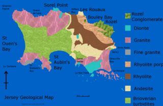
The geology of Jersey is characterised by the Late Proterozoic Brioverian volcanics, the Cadomian Orogeny, and only small signs of later deposits from the Cambrian and Quaternary periods. The kind of rocks go from conglomerate to shale, volcanic, intrusive and plutonic igneous rocks of many compositions, and metamorphic rocks as well, thus including most major types.

The geology of Tasmania is complex, with the world's biggest exposure of diabase, or dolerite. The rock record contains representatives of each period of the Neoproterozoic, Paleozoic, Mesozoic and Cenozoic eras. It is one of the few southern hemisphere areas that were glaciated during the Pleistocene with glacial landforms in the higher parts. The west coast region hosts significant mineralisation and numerous active and historic mines.

The geology of Alderney includes similarities in its rock to the neighbouring Normandy and Guernsey. Although Alderney is only five kilometers long, it has a geological history spanning half of the life of the earth. It is part of the Armorican Massif.

Cape Town lies at the south-western corner of the continent of Africa. It is bounded to the south and west by the Atlantic Ocean, and to the north and east by various other municipalities in the Western Cape province of South Africa.

The geology of Massachusetts includes numerous units of volcanic, intrusive igneous, metamorphic and sedimentary rocks formed within the last 1.2 billion years. The oldest formations are gneiss rocks in the Berkshires, which were metamorphosed from older rocks during the Proterozoic Grenville orogeny as the proto-North American continent Laurentia collided against proto-South America. Throughout the Paleozoic, overlapping the rapid diversification of multi-cellular life, a series of six island arcs collided with the Laurentian continental margin. Also termed continental terranes, these sections of continental rock typically formed offshore or onshore of the proto-African continent Gondwana and in many cases had experienced volcanic events and faulting before joining the Laurentian continent. These sequential collisions metamorphosed new rocks from sediments, created uplands and faults and resulted in widespread volcanic activity. Simultaneously, the collisions raised the Appalachian Mountains to the height of the current day Himalayas.
The geology of Malawi formed on extremely ancient crystalline basement rock, which was metamorphosed and intruded by igneous rocks during several orogeny mountain building events in the past one billion years. The rocks of the Karoo Supergroup and newer sedimentary units deposited across much of Malawi in the last 251 million years, in connection with a large rift basin on the supercontinent Gondwana and the more recent rifting that has created the East African Rift, which holds Lake Malawi. The country has extensive mineral reserves, many of them poorly understood or not exploited, including coal, vermiculite, rare earth elements and bauxite.

The geology of Sudan formed primarily in the Precambrian, as igneous and metamorphic crystalline basement rock. Ancient terranes and inliers were intruded with granites, granitoids, and volcanic rocks. Units of all types were deformed, reactivated, intruded, and metamorphosed during the Proterozoic Pan-African orogeny. Dramatic sheet flow erosion prevented almost any sedimentary rocks from forming during the Paleozoic and Mesozoic. From the Mesozoic into the Cenozoic, the formation of the Red Sea depression and complex faulting led to massive sediment deposition in some locations and regional volcanism. Sudan has petroleum, chromite, salt, gold, limestone, and other natural resources.

The geology of Arizona began to form in the Precambrian. Igneous and metamorphic crystalline basement rock may have been much older, but was overwritten during the Yavapai and Mazatzal orogenies in the Proterozoic. The Grenville orogeny to the east caused Arizona to fill with sediments, shedding into a shallow sea. Limestone formed in the sea was metamorphosed by mafic intrusions. The Great Unconformity is a famous gap in the stratigraphic record, as Arizona experienced 900 million years of terrestrial conditions, except in isolated basins. The region oscillated between terrestrial and shallow ocean conditions during the Paleozoic as multi-cellular life became common and three major orogenies to the east shed sediments before North America became part of the supercontinent Pangaea. The breakup of Pangaea was accompanied by the subduction of the Farallon Plate, which drove volcanism during the Nevadan orogeny and the Sevier orogeny in the Mesozoic, which covered much of Arizona in volcanic debris and sediments. The Mid-Tertiary ignimbrite flare-up created smaller mountain ranges with extensive ash and lava in the Cenozoic, followed by the sinking of the Farallon slab in the mantle throughout the past 14 million years, which has created the Basin and Range Province. Arizona has extensive mineralization in veins, due to hydrothermal fluids and is notable for copper-gold porphyry, lead, zinc, rare minerals formed from copper enrichment and evaporites among other resources.

The bedrock under the U.S. State of Colorado was assembled from island arcs accreted onto the edge of the ancient Wyoming Craton. The Sonoma orogeny uplifted the ancestral Rocky Mountains in parallel with the diversification of multicellular life. Shallow seas covered the regions, followed by the uplift current Rocky Mountains and intense volcanic activity. Colorado has thick sedimentary sequences with oil, gas and coal deposits, as well as base metals and other minerals.
The Stilbaai Marine Protected Area is an inshore conservation region in the territorial waters near Stilbaai on the south coast of the Western Cape province of South Africa.
