
Manukau City was a territorial authority district in Auckland, New Zealand, that was governed by the Manukau City Council. The area is also referred to as "South Auckland", although this term never possessed official recognition and does not encompass areas such as East Auckland, which was within the city boundary. It was a relatively young city, both in terms of legal status and large-scale settlement – though in June 2010, it was the third largest in New Zealand, and the fastest growing. In the same year, the entire Auckland Region was amalgamated under a single city authority, Auckland Council.
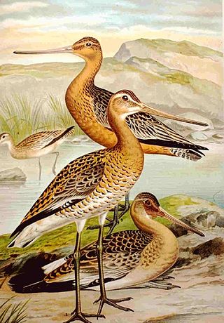
The godwits are a group of four large, long-billed, long-legged and strongly migratory waders of the bird genus Limosa. Their long bills allow them to probe deeply in the sand for aquatic worms and molluscs. In their winter range, they flock together where food is plentiful. They frequent tidal shorelines, breeding in northern climates in summer and migrating south in winter. A female bar-tailed godwit made a flight of 29,000 km (18,000 mi), flying 11,680 kilometres (7,260 mi) of it without stopping. In 2020 a male bar-tailed godwit flew about 12,200 kilometres (7,600 mi) non-stop in its migration from Alaska to New Zealand, previously a record for avian non-stop flight. In October 2022, a 5 month old, male bar-tailed godwit was tracked from Alaska to Tasmania, a trip that took 11 days, and recorded a non-stop flight of 8,400 miles (13,500 km).
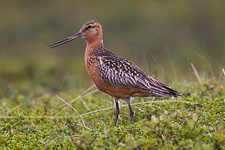
The bar-tailed godwit is a large and strongly migratory wader in the family Scolopacidae, which feeds on bristle-worms and shellfish on coastal mudflats and estuaries. It has distinctive red breeding plumage, long legs, and a long upturned bill. Bar-tailed godwits breed on Arctic coasts and tundra from Scandinavia to Alaska, and overwinter on coasts in temperate and tropical regions of Australia and New Zealand. The migration of the subspecies Limosa lapponica baueri across the Pacific Ocean from Alaska to New Zealand is the longest known non-stop flight of any bird, and also the longest journey without pausing to feed by any animal. The round-trip migration for this subspecies is over 29,000 km (18,020 mi).

Kaikōura is a town on the east coast of the South Island of New Zealand, located on State Highway 1, 180 kilometres (110 mi) north of Christchurch. The town has an estimated permanent resident population of 2,360 as of June 2023. Kaikōura is the seat of the territorial authority of the Kaikōura District, which is part of the Canterbury region.

Franklin District was a New Zealand territorial authority that lay between the Auckland metropolitan area and the Waikato Plains. As a formal territory, it was abolished on 31 October 2010 and divided between Auckland Council in the Auckland Region to the north and Waikato and Hauraki districts in the Waikato region to the south and east. The Auckland portion is now part of the Franklin Ward, which also includes rural parts of the former Manukau City.
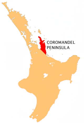
The Coromandel Peninsula on the North Island of New Zealand extends 85 kilometres (53 mi) north from the western end of the Bay of Plenty, forming a natural barrier protecting the Hauraki Gulf and the Firth of Thames in the west from the Pacific Ocean to the east. It is 40 kilometres (25 mi) wide at its broadest point. Almost its entire population lives on the narrow coastal strips fronting the Hauraki Gulf and the Bay of Plenty. In clear weather the peninsula is clearly visible from Auckland, the country's biggest city, which lies on the far shore of the Hauraki Gulf, 55 kilometres (34 mi) to the west. The peninsula is part of the Thames-Coromandel District and the Waikato Region.

Farewell Spit is a narrow sand spit at the northern end of the Golden Bay, in the South Island of New Zealand. The spit includes around 25 km (16 mi) of stable land and another 5 km (3.1 mi) of mobile sand spit running eastwards from Cape Farewell, the northern-most point of the South Island. Farewell Spit is the longest sand spit in New Zealand, and is a legally protected Nature Reserve. The area is designated as a Ramsar wetland site and an East Asian–Australasian Flyway Shorebird Network site. Farewell Spit is administered by the Department of Conservation as a seabird and wildlife reserve. Apart from a small area at the base of the spit, it is closed to the public except through organised tours. Conservation initiatives are in progress towards eliminating mammalian predators from Farewell Spit, including a proposal for a predator-proof fence.

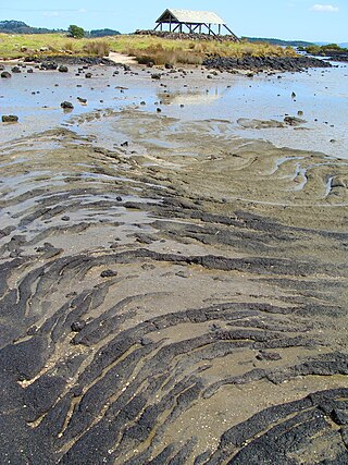
The Firth of Thames is a large bay located in the north of the North Island of New Zealand. It is the firth of the rivers Waihou and Piako, the former of which was formerly named the Thames River, and the town of Thames lies on its southeastern coast.
The Thames Valley is a non-administrative region in the North Island of New Zealand. Broadly, it is the valley component of the Waihou River catchment. The lower part of the valley is more commonly known as the Hauraki Plains. Geographically the valley extends as far as the Hinuera Gap, although this is not often referred to as such. In geographical history of New Zealand, the Thames Valley was the path of the ancestral Waikato River when it discharged into the Firth of Thames over 20,000 years ago.

The Hauraki Plains are a geographical area located in the northern North Island of New Zealand, at the lower (northern) end of the Thames Valley. They are located 75 kilometres south-east of Auckland, at the foot of the Coromandel Peninsula and occupy the southern portion of a rift valley bounded on the north-west by the Hunua Ranges, to the east by the Coromandel and Kaimai ranges and to the west by a series of undulating hills which separate the plains from the much larger plains of the Waikato River.

The Bombay Hills are a range of hills to the south of Auckland, New Zealand. Though only a small and seemingly insignificant range of hills, they lie at the southern boundary of the Auckland region, and serve as a divide between Auckland and the Waikato region. There is a 19th-century settlement, Bombay, on the old main road south of Auckland, the Great South Road.

HMS Orpheus was a Jason-class Royal Navy corvette that served as the flagship of the Australian squadron. Orpheus sank off the west coast of Auckland, New Zealand on 7 February 1863: 189 crew out of the ship's complement of 259 died in the disaster, making it the worst maritime tragedy to occur in New Zealand waters.

The Miranda Naturalists' Trust is a charitable trust, that established and maintains the Miranda Shorebird Centre, located at Pūkorokoro / Miranda on the western shore of the Firth of Thames on the North Island of New Zealand. The Miranda Naturalists' Trust (MNT) was formed in 1975 to encourage people to visit the coastline and appreciate its wide range of flora and fauna. The trust promotes education and public awareness of coastal ecology, shorebird research and conservation. Work done by the trust, to increase knowledge of shorebird migration, includes bird banding, research and data exchange. The Shorebird Centre has information displays on waders and a library and helps raise funds for the trust's work through their shop sales and visitor accommodation.

The Tapu River is a river of the Coromandel Peninsula in New Zealand's North Island. It flows west from the Coromandel Range, reaching the Firth of Thames at the settlement of Tapu, approximately halfway between Thames and Coromandel.

Kaiaua is a small coastal settlement on the Seabird Coast, on the western shore of the Firth of Thames, in the Hauraki District and Waikato region of New Zealand's North Island. It is 80km from Auckland.

Onemana is a 1970s beach village on the eastern side of the Coromandel Peninsula of New Zealand, with a beach, a surf club, fire station and dairy. It lies 3 km (1.9 mi) to the east of State Highway 25, south of Pauanui and north of Whangamatā. The Wharekawa River and Opoutere are just to the north and west.
Kawakawa Bay is an east coast bay and settlement in the Franklin area of New Zealand's Auckland Region.
Ambury Regional Park is a regional park situated on the coast of Manukau Harbour, in Auckland in New Zealand's North Island. It is situated in the suburb of Māngere Bridge and in the local board area of Māngere-Ōtāhuhu, to the west of Māngere Mountain.
Whakatīwai Regional Park is a regional park on New Zealand's North Island. It runs from the eastern side of the Hunua Ranges, where it adjoins Hunua Ranges Regional Park, down to the Firth of Thames coast, just north of the settlement of Whakatīwai. It is in the Hauraki District and the Waikato Region, not far from the border with the Auckland Region, and is owned and operated by Auckland Council.
Whakatīwai is a locality on the Seabird Coast on the western shore of the Firth of Thames, in the Hauraki District, New Zealand. Whakatīwai is the location of Wharekawa Marae, which holds importance for Ngāti Paoa and Ngāti Whanaunga. Whakatīwai Regional Park is just north of Whakatīwai. Until 2010, Whakatīwai was a part of the Franklin District. Because it was previously considered a part of the Auckland region, the Whakatīwai Regional Park continues to be owned and operated by the Auckland Council.
