Seabreeze, Florida

Last updated
Seabreeze Historic District
Volusia County Florida No Highlights.svg
Red pog.svg
Located in Volusia County, Florida
Location Volusia County, Florida, US
Nearest city Daytona Beach
Coordinates 29°14′00″N81°00′53″W / 29.23333°N 81.01472°W / 29.23333; -81.01472
Area1,700 acres (6.9 km2)
ArchitectGriffin, Harry, et al.
Architectural style Queen Anne, Late 19th And 20th Century Revivals, Late 19th And Early 20th Century American Movements
MPS Daytona Beach Multiple Property Submission
NRHP reference No. 98001131 [1]
Added to NRHPSeptember 3, 1998

Seabreeze is a beachside neighborhood in Daytona Beach, Florida, which existed as an independent city from May 24, 1901, until January 1, 1926, when it merged with Daytona and Daytona Beach to become one consolidated city.

Contents

Seabreeze has been memorialized as the Seabreeze Historic District, a U.S. Historic District (designated as such on September 3, 1998). The district is bounded by University Boulevard, Halifax Road, Auditorium Boulevard, and North Atlantic Avenue. It contains 596 historic buildings. [2] [3] [4]

History

In 1884 David D. Rogers bought 47 acres (190,000 m2) of land on the beach peninsula, east of Daytona, stretching from present-day Main Street on the north to Harvey Street on the south, and from the Atlantic Ocean on the east, to Pinewood Cemetery on the west. Rogers divided the property into lots for sale and named the development Seabreeze.

Early picture of Ocean Blvd. (Seabreeze Blvd.) 1893 Seabreeze rc07627.jpg
Early picture of Ocean Blvd. (Seabreeze Blvd.) 1893

In 1885, Charles A. Ballough built a homestead north of the Rogers development, roughly from the present-day Oakridge Boulevard, stretching north to the present University Boulevard. In 1886, Charles H. Brush built a homestead on 60 acres (240,000 m2) of land between the Rogers and Ballough properties, stretching from the Atlantic Ocean on the east and about halfway across the peninsula. In 1888, Brush sold half of his property, which was developed into a subdivision.

In 1886, a post office named Halifax was established on the peninsula, located on the riverfront near present-day Main Street. In 1890, the Post Office Department changed the name of this post office to Seabreeze to match the name of Rogers' development.

In 1887, the first bridge was opened across the Halifax River from Daytona to the peninsula. It was called the Central Bridge (named the Main Street Bridge today, carrying CR 4040) and connected Fairview Ave. in Daytona to Seabreeze Ave. (named Main St. today), in old Daytona Beach.

Westbound view down Ocean Blvd. (Seabreeze Blvd.), 1902 Seabreeze rc09056.jpg
Westbound view down Ocean Blvd. (Seabreeze Blvd.), 1902

In 1892, Col. C. C. Post and his wife, Helen Wilmans Post, bought half of Ballough's property, which they turned into another development, and would later become the core of the town of Seabreeze. They opened Ocean Boulevard (today named Seabreeze Blvd.) from Valley St. (today named Halifax Ave.) to the ocean and paved it with marl. Col. Post built a store, an opera house, a printing office, and a residence for his family. Mrs. Post founded a school of "Mental Science" and began publishing a paper named "Freedom," on the subject.

The volume of mail connected with the "Mental Science" activities had grown so much, that by 1897, the Post Office Department decided to move the Seabreeze post office north to Ocean Blvd. The moving of "their" post office greatly upset the residents living around Seabreeze Ave., who petitioned the Post Office Department for a new post office. The request was granted in 1898, and a new post office was granted with the name of Goodall (named after Congressman Ernest Goodall of Maine), also located at the corner of Valley St. (Halifax Ave.) and Seabreeze Ave. (Main St.). [2] [3] [4]

Incorporation

Historical population
CensusPop.Note
1910 308
1920 57185.4%
Seabreeze [5] [6]

On May 24, 1901, the citizens living in the Seabreeze post office area voted to incorporate the development. They elected Col. C. C. Post as the first mayor, chose five town council members and other officials. Mrs. Post promoted the new town as "City Beautiful."

In 1902, a bridge was constructed from Ocean Blvd. in Seabreeze to Mason Ave. on the mainland, at the northern border of Daytona. Originally called the North Bridge, it later became known as the Seabreeze Bridge.

On January 28, 1905, the residents around the Goodall post office assembled to discuss the matter of incorporation. Several meetings followed, until on March 23, 1905, and election meeting was held where 41 votes were cast for incorporation as Daytona Beach. The first mayor was E. E. Johnson. The dividing line between Daytona Beach and Seabreeze was located roughly at today's Auditorium Blvd. [2] [3] [4]

Consolidation

In 1925, representatives of Daytona, Daytona Beach, and Seabreeze met to discuss merger of the three cities. On January 1, 1926, a consolidated City of Daytona Beach replaced the three smaller municipalities. [7] This made Daytona the seventh largest city in Florida by population. [8]

See also

Related Research Articles

<span class="mw-page-title-main">Volusia County, Florida</span> County in Florida, United States

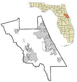
Volusia County is a county located in the east-central part of the U.S. state of Florida between the St. Johns River and the Atlantic Ocean. As of the 2020 census, the county was home to 553,543 people, an increase of 11.9% from the 2010 census. It was founded on December 29, 1854, from part of Orange County, and was named for the community of Volusia, located in northwestern Volusia County. Its first county seat was Enterprise. Since 1887, its county seat has been DeLand.

<span class="mw-page-title-main">Daytona Beach, Florida</span> City in Florida, United States

Daytona Beach is a coastal resort city in Volusia County, Florida, United States. Located on the East Coast of the United States, its population was 72,647 at the 2020 census. It is part of the Deltona–Daytona Beach–Ormond Beach metropolitan area, and is a principal city of the Fun Coast region of Florida.

<span class="mw-page-title-main">Ormond Beach, Florida</span> City in Volusia County, Florida, US

Ormond Beach is a city in Volusia County, Florida, United States. The population was 43,080 at the 2020 census. Ormond Beach lies directly north of Daytona Beach and is a principal city of the Deltona–Daytona Beach–Ormond Beach, FL Metropolitan Statistical Area. The city is known as the birthplace of speed, as early adopters of motorized cars flocked to its hard-packed beaches for yearlong entertainment, since paved roads were not yet commonplace. Ormond Beach lies in Central Eastern Florida.

<span class="mw-page-title-main">Ormond-by-the-Sea, Florida</span> CDP in Florida, United States

Ormond-by-the-Sea is a census-designated place and an unincorporated town in Volusia County, Florida, United States. The population was 7,312 as of the 2020 census, a decrease from 7,406 in the 2010 census.

<span class="mw-page-title-main">South Daytona, Florida</span> City in Florida, United States

South Daytona is a city in Volusia County, Florida, United States. The population was 12,865 at the 2020 census.

<span class="mw-page-title-main">U.S. Route 92</span> Highway in the United States

U.S. Route 92 or U.S. Highway 92 is a 181-mile (291 km.) U.S. Route entirely in the U.S. state of Florida. The western terminus is at US 19 Alt. and SR 687 in downtown St. Petersburg. The eastern terminus is at SR A1A in Daytona Beach.

<span class="mw-page-title-main">Broadway Bridge (Daytona Beach)</span> Bridge in Daytona Beach, Florida, US

The Broadway Bridge is a segmental bridge that spans the Halifax River and Intracoastal Waterway in downtown Daytona Beach, Florida, carrying U.S. Route 92.

<span class="mw-page-title-main">Florida State Road 5A</span> State highway in Florida, United States

State Road 5A (SR 5A), also known as Nova Road, is a north–south highway that begins and ends at U.S. Highway 1 or US 1, in Port Orange and Ormond Beach, respectively. It is noted that when 5A was built, it was used more as a bypass or beltway, but in recent years with growth reaching far beyond SR 5A, it sees more use as a major thoroughfare that passes through the heart of the region.

<i>The Daytona Beach News-Journal</i> Newspaper in Florida, U.S.

The Daytona Beach News-Journal is a Florida daily newspaper serving Volusia and Flagler Counties.

<span class="mw-page-title-main">Florida State Road 441</span> State highway in Florida, United States

State Road 441 is a 5.4-mile-long (8.7 km) street in Port Orange, Daytona Beach Shores, and Daytona Beach. It is locally known as Peninsula Drive, and signed as a north–south road.

<span class="mw-page-title-main">Florida State Road 430</span> State highway in Florida, United States

State Road 430 is an east–west state highway in Daytona Beach, running between SR 483/Clyde Morris Boulevard and SR A1A/Atlantic Avenue.

<span class="mw-page-title-main">Halifax River</span> River in Florida, United States

The Halifax River is part of the Atlantic Intracoastal Waterway, located in northeast Volusia County, Florida. The waterway was originally known as the North Mosquito River, but was renamed after George Montagu-Dunk, 2nd Earl of Halifax, during the British occupation of Florida (1763–1784).

A sea breeze is a wind from the sea.

<span class="mw-page-title-main">Daytona Beach Bandshell</span> United States historic place

The Daytona Beach Bandshell is an amphitheatre in Daytona Beach, Florida, United States. It is located at Ocean Avenue, north of the junction of Main Street and Atlantic Avenue. On March 5, 1999, it was added to the U.S. National Register of Historic Places. On April 18, 2012, the AIA's Florida Chapter placed the Daytona Beach Bandshell on its list of Florida Architecture: 100 Years. 100 Places.

<span class="mw-page-title-main">Tarragona Tower</span> United States historic place

The Tarragona Tower is a structure in Daytona Beach, Florida. Completed in 1925, the building was created to mark the entrance to the Daytona Highlands Mediterranean Revival residential development, and features a Spanish Revival design. As the structure was partially demolished in 1942, and relocated entirely in 1994, a restoration of the tower was completed in 2004. In 2005, the tower was listed on the National Register of Historic Places, but remains inaccessible to the public.

<span class="mw-page-title-main">Granada Bridge (Ormond Beach)</span> Structure in Florida, United States

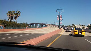
The Granada Bridge is a high-clearance bridge that spans the Halifax River and Intracoastal Waterway, linking the mainland and beach peninsula parts of Ormond Beach, Volusia County, Florida. Granada Bridge carries four lanes of State Road 40 and Granada Blvd. The Casements, along with City Hall Plaza, Fortunato Park, and Riverbridge Park reside at the four corners of Ormond Beach's Granada Bridge, which give their collective name to the annual "Four Corners Festival" in Ormond Beach.

<span class="mw-page-title-main">Halifax area</span> Region in Florida

The Halifax area or simply Daytona is a region of the U.S. state of Florida, comprising the area around Daytona Beach. It is roughly coextensive with the Daytona Beach metropolitan area and Volusia County. There have been a number of attempts to establish a regional identity for Daytona, including dubbing it the "Surf Coast" and "Fun Coast". The name "Halifax area" refers to the Halifax River, which runs through Daytona Beach and other nearby municipalities.

<span class="mw-page-title-main">Ormond Scenic Loop and Trail</span>

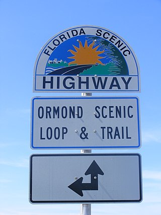
The Ormond Scenic Loop and Trail is a series of scenic state and county highways in Volusia County, Florida. CR 2002 is the northern leg of the trail. CR 4011(Old Dixie Highway and North Beach Street) is the western leg, with a spur onto Pine Tree Drive. SR 40(East Granada Boulevard) is the southern leg of the trail. CR 2803(John Anderson Drive) is the central leg of the trail, and SR A1A is the eastern leg of the trail. Florida Scenic Highway, designated this route on July 9, 2007.

<span class="mw-page-title-main">Wilbur B. Talley</span> American architect

Wilbur B. Talley was an architect in Florida. He worked in Jacksonville until the death of his wife Nellie and daughter Sarah, who were riding in a car hit by a train on December 21, 1919. After the accident, he moved to Lakeland, Florida where he continued working as an architect.

<span class="mw-page-title-main">Sumner Hale Gove</span> American architect

Sumner Hale Gove was an American businessman, politician, and prolific developer and architect. During the early 1880s, he was employed as a carpenter and builder in the Groton, Connecticut area. In 1882, he served as a member of the Connecticut General Assembly.

References

  1. "National Register Information System". National Register of Historic Places . National Park Service. July 9, 2010.
  2. 1 2 3 Gold, Pleasant Daniel (1927). History of Volusia County, Florida. DeLand, FL: The E. O. Painter Printing Co.
  3. 1 2 3 Centennial History of Volusia County, Florida (18541954) Volusia County Historical Commission
  4. 1 2 3 "Residents remember old town of Seabreeze". The Daytona Beach News-Journal . December 15, 1997.
  5. US Census Bureau
  6. US Census Bureau
  7. "Faith in Florida is Expressed at Banquet Held in Daytona Beach: Prominent Men Praise State: Consolidation of Daytona, Daytona Beach and Seabreeze Was Effective at Midnight - Celebration Being Held". Associated Press. The Orlando Sentinel. January 1, 1926. p. 1.
  8. "Three Cities Unite as New Year Opens". Associated Press. Tampa Morning Tribune. January 1, 1926. p. 12-A.