Related Research Articles

The Australian Capital Territory (ACT), known as the Federal Capital Territory (FCT) until 1938, is a federal territory of Australia. Canberra, the capital city of Australia, is located in this territory. It is located in southeastern Australian mainland as an enclave completely within the state of New South Wales. Founded after Federation as the seat of government for the new nation, the territory hosts the headquarters of all important institutions of the Australian Government.

The Jervis Bay Territory is an internal territory of Australia. It was established in 1915 from part of New South Wales (NSW), in order to give the landlocked Australian Capital Territory (ACT) access to the sea.
A federal district is a type of administrative division of a federation, usually under the direct control of a federal government and organized sometimes with a single municipal body. Federal districts often include capital districts, and they exist in various federations worldwide.

Jervis Bay is a 102-square-kilometre (39 sq mi) oceanic bay and village on the south coast of New South Wales, Australia, said to possess the whitest sand in the world.

Sir Austin Chapman was an Australian politician who served in the House of Representatives from 1901 until his death in 1926. He held ministerial office in the governments of Alfred Deakin and Stanley Bruce, serving as Minister for Defence (1903–1904), Postmaster-General (1905–1907), Minister for Trade and Customs, and Minister for Health (1923–1924).
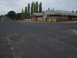
Dalgety is a small town in New South Wales, Australia, on the banks of the Snowy River between Melbourne and Sydney.

Egerton Lee Batchelor was an Australian politician and trade unionist. He was a pioneer of the Australian Labor Party (ALP) in South Australia, which at the time was known as the United Labor Party (ULP). He was a member of the South Australian House of Assembly (1893–1901), leading the ULP from 1898 until his resignation in 1899 to accept a ministerial post in a non-Labor government, with the party's approval. Batchelor entered federal politics in 1901 and held cabinet posts in the first three ALP governments. He was Minister for Home Affairs (1904) under Chris Watson, and then served two terms as Minister for External Affairs under Andrew Fisher. He suffered a fatal heart attack at the age of 46 while climbing Mount Donna Buang.

Sir Littleton Ernest Groom KCMG KC was an Australian politician. He held ministerial office under four prime ministers between 1905 and 1925, and subsequently served as Speaker of the House of Representatives from 1926 to 1929.

Hall is a town in the district of Hall, in the Australian Capital Territory in Australia. Is situated on the north side of the Australian Capital Territory. At the 2021 census, the village had a population of 298 people. It is surrounded by open country and has a rural appearance. Hall has retained a village character. The town features historic buildings that existed before the establishment of Canberra.

Sir Joseph Hector McNeil Carruthers was an Australian politician who served as Premier of New South Wales from 1904 to 1907.
The history of the Australian Capital Territory (ACT) as a separate administrative division began in 1911, when it was transferred from New South Wales to the Australian federal government. The territory contains Australia's capital city Canberra and various smaller settlements. Until 1989, it also administered the Jervis Bay Territory, a small coastal region.
The Seat of Government Acceptance Act 1909 is an Australian Commonwealth Government act, that in conjunction with the Seat of Government Surrender Act 1909 transferred land from the state of New South Wales to the Commonwealth for the creation of the Federal Capital Territory.

The Seat of Government Act 1904 was an Act of the Parliament of Australia which provided that the "seat of government of the Commonwealth" should be within 17 miles (27 km) of Dalgety, New South Wales.

The Seat of Government Surrender Act 1909 is an Act of the New South Wales Parliament which completed the transfer of land from New South Wales to establish the Federal Capital Territory as the seat of Commonwealth government. The Act became law on 14 December 1909, the day after the Seat of Government Acceptance Act 1909 had been passed by the Commonwealth government.

The states and territories are federated administrative divisions in Australia, ruled by regional governments that constitute the second level of governance between the federal government and local governments. States are self-governing polities with incomplete sovereignty and have their own constitutions, legislatures, departments, and certain civil authorities that administer and deliver most public policies and programs. Territories can be autonomous and administer local policies and programs much like the states in practice, but are still constitutionally and financially subordinate to the federal government and thus have no true sovereignty.

The first colonies of the British Empire on the continent of Australia were the penal colony of New South Wales, founded in 1788, and the Swan River Colony, founded in 1829. Over the next few decades, the colonies of New Zealand, Queensland, South Australia, Van Diemen's Land, and Victoria were created from New South Wales, as well as an aborted Colony of North Australia. On 1 January 1901, these colonies, excepting New Zealand, became states in the Commonwealth of Australia. Since federation, the internal borders have remained mostly stable, except for the creation of some territories with limited self-government: the Northern Territory from South Australia, to govern the vast, sparsely populated centre of the country; the split of the Northern Territory into Central Australia and North Australia, and then the quick merger of those back into the Northern Territory; and the Australian Capital Territory, a federal district ceded from New South Wales.

Murray County was one of the original Nineteen Counties in New South Wales and is now one of the 141 Lands administrative divisions of New South Wales. It included the area which is now part of Canberra and as far north as Lake George and Yass. It was originally bounded on the west by the Murrumbidgee River, on the east by the Shoalhaven River and on the north by the Yass River. A large area of the county was transferred to the Commonwealth government in 1909 in the Seat of Government Acceptance Act to make part of the Australian Capital Territory, along with land in Cowley County. Since then, the ACT border is now part of the western boundary. Part of the ACT border is determined by property boundaries in the Parish of Keewong, in the County of Murray; specifically the southern end of portions 177, 218, 211, 36, and 38. This is mentioned in the Seat of Government Acceptance Act of 1909.
Mount Coree is a mountain with an elevation of 1,421 metres (4,662 ft) AHD that is located within the Brindabella Range on the border between the Australian Capital Territory and New South Wales, Australia. The summit of the mountain is located in the Australian Capital Territory.
Mahkoolma was the name given to one of the sites proposed for Australia's national capital city, prior to selection of Canberra. The name Mahkoolma is not used today, and the once proposed city site now lies across the boundary of the modern-day localities of Bookham and Burrinjuck, New South Wales.
References
- National Archives of Australia: Documenting Democracy - Seat of Government Act 1908