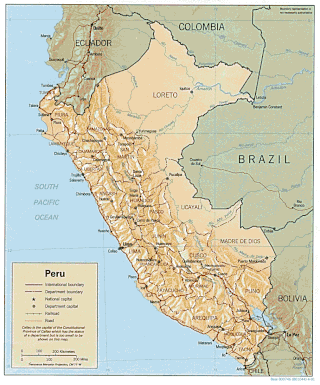
Peru is a country on the central western coast of South America facing the Pacific Ocean. It lies wholly in the Southern Hemisphere, its northernmost extreme reaching to 1.8 minutes of latitude or about 3.3 kilometres (2.1 mi) south of the equator. Peru shares land borders with Ecuador, Colombia, Brazil, Bolivia, and Chile, with its longest land border shared with Brazil.

Nazca is a city and system of valleys on the southern coast of Peru. The city of Nazca is the largest in the Nazca Province. The name is derived from the Nazca culture, which flourished in the area between 100 BC and AD 800. This culture was responsible for the Nazca Lines and the ceremonial city of Cahuachi. They also constructed additional underground aqueducts, named puquios, in a regional system that still functions today. The first puquios are believed to have been built by the preceding Paracas culture.

Pisco is a city located in the Department of Ica of Peru, the capital of the Pisco Province. The city is around 9 metres above sea level. Pisco was founded in 1640, close to the indigenous emplacement of the same name. Pisco originally prospered because of its nearby vineyards and became noted for its grape brandy or pisco which was exported from its port. Pisco has an estimated population of 104,656.

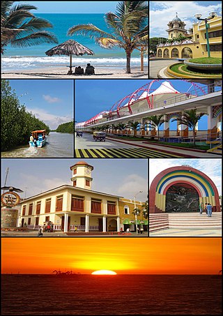
Piura is a city in northwestern Peru located north of the Sechura Desert on the Piura River. It is the capital of the Piura Region and the Piura Province. Its population was 484,475 as of 2017 and is the 7th most populous city in Peru. The city is located in the central eastern part of the Piura Region, 981 kilometers from the countrys capital, Lima and is near to the border with Ecuador.

Puno is a city in southeastern Peru, located on the shore of Lake Titicaca. It is the capital city of the Puno Region and the Puno Province with a population of approximately 140,839. The city was established in 1668 by viceroy Pedro Antonio Fernández de Castro as capital of the province of Paucarcolla with the name San Juan Bautista de Puno. The name was later changed to San Carlos de Puno, in honor of king Charles II of Spain. Puno has several churches dating back from the colonial period; they were built to service the Spanish population and evangelize the Quechua people.
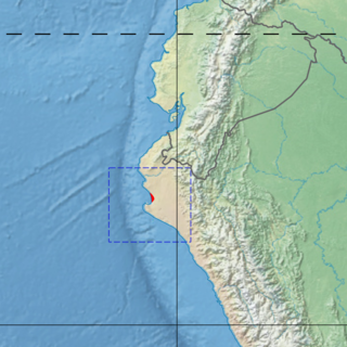
Piura is a coastal department and region in northwestern Peru. The region's capital is Piura and its largest port cities, Paita and Talara, are also among the most important in Peru. The area is known for its tropical and dry beaches. It is the most populous department in Peru, its twelfth smallest department, and its fourth-most densely populated department, after Tumbes, La Libertad, and Lambayeque.

Ica is a city and the capital of the Department of Ica in southern Peru. While the area was long inhabited by varying cultures of indigenous peoples, the Spanish conquistador Jerónimo Luis de Cabrera claimed its founding in 1563.
Tumbes is a city in northwestern Peru, on the banks of the Tumbes River. It is the capital of the Tumbes Region, as well as of Tumbes Province and Tumbes District. Located near the border with Ecuador, Tumbes has 111,595 inhabitants as of 2015. It is served by the Cap. FAP Pedro Canga Rodriguez Airport. It is located on the Gulf of Guayaquil along with Zorritos.

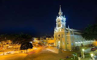
Lambayeque is a city on the coast of northern Peru and capital of the homonymous district and province in the department of Lambayeque. It is located 4.7 km from the city of Chiclayo and 13 km from the Pacific Ocean. It is an important cultural and educational center of the department as it houses some of the most important museums in the country, such as the Royal Tombs Museum and the Brüning Museum. It was founded in 1553 under the name of San Pedro de Lambayeque by order of the Viceroy Conde de Nieva.
Puerto Maldonado is a city in southeastern Peru in the Amazon rainforest 55 kilometres (34 mi) west of the Bolivian border, located at the confluence of the Tambopata and Madre de Dios rivers. The latter river joins the Madeira River as a tributary of the Amazon. This city is the capital of the Department of Madre de Dios.

Huancayo is the capital of the Junín Region and Huancayo Province, in the central highlands of Peru, in the Mantaro Valley and is crossed by the Shullcas, Chilca and Mantaro rivers. It was founded as a reduction by the name Santísima Trinidad de Huancayo on 1 June 1572, by Don Jerónimo de Silva, a Spanish conquistador. It is the fifth largest city in Peru, with a population of 500,000 and is among the highest cities in Peru, with an altitude of 3,256 meters above sea level. It is considered the economic and social center of central Peru

Ayabaca is a town in the highlands of the Piura Region in northwestern Peru, near the border with Ecuador. It is located in the Ayabaca Province and is capital of that province and Ayabaca District, to the southeast of the Ecuadorian border town of Macará.
Sullana is a city in Peru and the capital of the Sullana Province, Piura, in the north-western coastal plains of Peru on the Chira valley. The city is home to 162,500 people and is one of the most important cities in the Department of Piura.
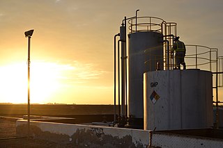
Talara is a city in the Talara Province of the Piura Region, in northwestern Peru. It is a port city on the Pacific Ocean with a population of 91,444 as of 2017. Its climate is hot and dry. Due to its oil reserves, and ability to produce aviation fuel, Talara hosted a United States air base during World War II. It was also one of two refueling stations for the Pacific Fleet. There were naval guns on the hills, and submarine nets in the harbor. The Ajax, Achilles and Exeter, three British destroyers, were refuelled there on their way around the Horn to catch the Graf Spee in Rio de la Plata. Talara is also home to a large fishing fleet. The city is served by the Cap. FAP Víctor Montes Arias Airport.

Chachapoyas is a city in northern Peru at an elevation of 2,335 meters (7,661 ft). The city has a population of 32,026 people (2017). Situated in the mountains far from the Peruvian coast, Chachapoyas remains fairly isolated from other regions of Peru. It is served by buses to Chiclayo and Cajamarca, and flights to domestic locations from Chachapoyas Airport.

Tarapoto is a commercial hub town in the San Martín Province of the Department of San Martín of northern Peru. It is an hour by plane from Lima, in the high jungle plateau to the east of what is known as the selva baja. Although Moyobamba is the capital of the region, Tarapoto is the region's largest city and is linked to the Upper Amazon and the historic city of Yurimaguas by a relatively well-maintained transandean highway, paved in 2008–9.
Rioja is the capital of Rioja Province in the San Martín Region in northern Peru. It is situated to the west of Moyobamba. There are 24,263 inhabitants according to the 2007 census.

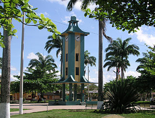
Chulucanas is a town in Morropón Province, Piura Region, Peru. It lies in the Piura Valley just north of the confluence of the Charanal River with the Piura River. Chulucanas is the administrative seat for both Chulucanas District and Morropón Province.
Cutervo is a town in northern Peru, capital of both Cutervo District and Cutervo Province in Cajamarca Region. As of 2020, Cutervo had a population of 51,272.
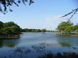
The Piura mangroves ecoregion covers a very small mangrove site on the Piura River Delta, on the Pacific Ocean in northwestern Peru. This small mangrove site is at the northern tip of the Sechura Desert. The climate is normally semi-arid, but cn be much wetter in El Nino years. The area is a RAMSAR wetland of international importance "Manglares de San Pedro de Vice", and is an important stopover for migratory birds.