Secondary state highways as branches of Primary State Highway 7 (Washington)
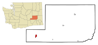
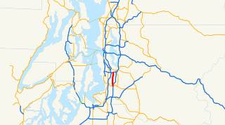
Last updated Map of the secondary branches of Primary State Highway 7. Click on the map for a closer look.
Between 1937 and 1964, the highway system in the state of Washington consisted of a series of primary state highways (PSH), most of which were associated with one or more secondary state highways (SSH). The following are the secondary state highways formerly associated with Primary State Highway 7.
A highway is any public or private road or other public way on land. It is used for major roads, but also includes other public roads and public tracks: It is not an equivalent term to controlled-access highway, or a translation for autobahn, autoroute, etc.
Secondary State Highway 7B, commissioned in 1937, was a short (about 6 miles) route that extended due east from U.S. Route 97 (PSH 3 south of Ellensburg, took a 90-degree turn to the north at Kittitas, and terminated at PSH 7/U.S. Route 10 about a mile north of Kittitas. SSH 7B was removed from the state highway system in 1953. The route is not part of the modern Washington state route system.
Ellensburg is a city in and county seat of Kittitas County, Washington, United States. The population was 20,326 in a 2017 census estimate. Located just east of the Cascade Range on Interstate 90, Ellensburg is the most centrally located city in the state, and is the home of Central Washington University (CWU).
Kittitas is a city in Kittitas County, Washington, United States. The population was 1,381 at the 2010 census. The population was 1,450 at 2012 Estimate from Office of Financial Management.
SSH 7C
When it was added to the state highway system in 1951, Secondary State Highway 7C originated at US 10/PSH-7 at the east end of the Vantage Bridge, at a point where the main highway turned north to climb out of the Columbia River Valley. From the banks of the Columbia, SSH 7C headed east to a junction with US 395/PSH 11 west of Othello, remaining roughly parallel to US 10 but taking a more southerly route. In 1961, SSH 7B was extended east to SSH 11B in Washtucna. Today, SSH 7C is part of SR 26.
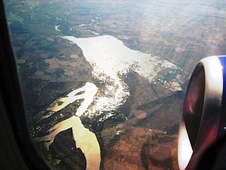
The Vantage Bridge is a bridge in the U.S. state of Washington. It carries Interstate 90 across the Columbia River, near Vantage and George, Washington. This section of the river is named Wanapum Lake; it is the reservoir formed by Wanapum Dam. The bridge separates the Ginkgo Petrified Forest and Wanapum Recreational Area State Park on the western bank of the Columbia.
The Columbia River is the largest river in the Pacific Northwest region of North America. The river rises in the Rocky Mountains of British Columbia, Canada. It flows northwest and then south into the US state of Washington, then turns west to form most of the border between Washington and the state of Oregon before emptying into the Pacific Ocean. The river is 1,243 miles (2,000 km) long, and its largest tributary is the Snake River. Its drainage basin is roughly the size of France and extends into seven US states and a Canadian province. The fourth-largest river in the United States by volume, the Columbia has the greatest flow of any North American river entering the Pacific.
Othello is a city in Adams County, Washington, United States. The population was 5,847 at the 2000 census and grew 25.9% over the next decade to 7,364 at the 2010 census. In the 2018 census, it was 8,099. Othello refers to the city as being in the "Heart" of the Columbia Basin Project. It is located approximately 100 miles (160 km) southwest of Spokane, 180 miles (290 km) east of Seattle, and about 25 miles (40 km) south of Interstate 90, at the intersection of SR 17 and SR 26.
Beginning in 1957, a branch of SSH 7C originated at the SSH 7C trunk route about a mile south of its western terminus at US 10, then followed the bank of the Columbia south and east to a junction with SSH 7A, just inside the Hanford Site. Today, SSH 7C is SR 243.
The Hanford Site is a decommissioned nuclear production complex operated by the United States federal government on the Columbia River in the Benton County in the U.S. state of Washington. The site has been known by many names, including Hanford Project, Hanford Works, Hanford Engineer Works and Hanford Nuclear Reservation. Established in 1943 as part of the Manhattan Project in Hanford, south-central Washington, the site was home to the B Reactor, the first full-scale plutonium production reactor in the world. Plutonium manufactured at the site was used in the first nuclear bomb, tested at the Trinity site, and in Fat Man, the bomb detonated over Nagasaki, Japan.
State Route 243 (SR 243) is a state highway in Grant County, Washington. It travels north–south along the Columbia River for 28 miles (45 km), connecting SR 24 at the Vernita Bridge to SR 26 near Vantage. The highway travels through a predominantly rural and desert area, serving two hydroelectric dams and the communities of Desert Aire, Mattawa, and Beverly.
SSH 7E
In 1955, a state law created a corridor for an unconstructed highway, designated Secondary State Route 7E, extending from US 10/PSH 18 in Moses Lake northeast to PSH 7 west of Odessa. The only part of this route that was ever constructed and signed as SSH 7E was a 3.8-mile (6.1km) road through Moses Lake from US 10 (later Interstate 90)/PSH 18 in the southwest to SSR 11G in the northeast. Today, this route is SR 171. The leg from SSR 11G (today's SR 17) to the Odessa area has never been constructed and is not part of the modern state route system.
Moses Lake is a city in Grant County, Washington, United States. The population was 20,366 as of the 2010 census. Moses Lake is the largest city in Grant County. The city anchors the Moses Lake Micropolitan area, which includes all of Grant County, and is part of the Moses Lake-Othello combined statistical area.
Odessa is a town in Lincoln County, Washington, United States. The population was 910 at the 2010 census.
State Route 171 is a 3.79-mile (6.10 km) long state highway serving the city of Moses Lake in Grant County, located in the U.S. state of Washington. Broadway Avenue begins at an interchange with Interstate 90 (I-90) and travels northeast through Downtown Moses Lake concurrent to Interstate 90 Business and parallel to Parker Horn before ending at an intersection with SR 17. Broadway Avenue was previously part of Primary State Highway 18 (PSH 18) and U.S. Route 10 (US 10) until the 1964 highway renumbering. The highway also has an un-built extension from Moses Lake northeast to Odessa that was first legislated in 1955 as Secondary State Highway 7E (SSH 7E).
This page is based on this Wikipedia article Text is available under the CC BY-SA 4.0 license; additional terms may apply. Images, videos and audio are available under their respective licenses.
Related Research Articles
State Route 104 (SR 104) is a 31.75-mile-long (51.10 km) state highway in the U.S. state of Washington, serving four counties: Jefferson on the Olympic Peninsula, Kitsap on the Kitsap Peninsula, and Snohomish and King in the Puget Sound region. It begins south of Discovery Bay at U.S. Route 101 (US 101) south of Discovery Bay and crosses the Hood Canal Bridge over Hood Canal to the terminus of SR 3 near Port Gamble. SR 104 continues southeast onto the Edmonds–Kingston Ferry to cross the Puget Sound and intersects SR 99 and Interstate 5 (I-5) before ending at SR 522 in Lake Forest Park. SR 104 also has a short spur route that connects the highway to SR 99 at an at-grade signal on the Snohomish–King county line.
State Route 14 (SR 14) is a 180.66-mile-long (290.74 km) state highway in the U.S. state of Washington. The highway travels east-west on the north side of the Columbia River, opposite Interstate 84 (I-84) to the south in Oregon. SR 14 forms a section of the Lewis and Clark Trail Scenic Byway and begins at an interchange with I-5 in Vancouver. The highway travels east as a four-lane freeway through Camas and Washougal and intersects I-205. SR 14 continues east as a two-lane highway through Clark, Skamania, Klickitat, and Benton counties before it ends at an interchange with I-82 and U.S. Route 395 (US 395) near Plymouth.
State Route 401 (SR 401) is a 12.13-mile (19.52 km) long state highway in Pacific County within the U.S. state of Washington. The highway originates at the north end of the Astoria–Megler Bridge west of Megler at an intersection with U.S. Route 101 (US 101). The roadway travels northeast, paralleling cliffs, the Columbia River and the South Fork of the Naselle River to Naselle, ending at SR 4. The road was designated Secondary State Highway 12B (SSH 12) between 1937 and 1964, when SR 401 was created to replace SSH 12B. The Astoria–Megler Bridge, completed in 1966, replaced a ferry east of the bridge, where the highway originally ended, and is known locally as Kingston Ferry Road. The roadway was extended west to the north end of the bridge, where it currently terminates. The former ferry terminal became the Dismal Nitch rest area, named after the Lewis and Clark Expedition's description of the place.
State Route 31 (SR 31) is a Washington state highway located entirely in Pend Oreille County. The highway, which is 26.79 miles (43.11 km) long, starts at an intersection with SR 20 in Tiger and travels north to the Canada–US border north of Metaline Falls. At the border, SR 31 becomes British Columbia Highway 6 (BC 6). The route parallels the Pend Oreille River for most of its route and the primary functions of the highway is to serve and connect Tiger, Ione, Metaline and Metaline Falls with British Columbia.
State Route 21 (SR 21) is a 191.34-mile (307.93 km) long state highway in the U.S. state of Washington that traverses four counties: Franklin, Adams, Lincoln and Ferry. The highway extends from an intersection with SR 260 in Kahlotus north through Lind, Odessa, Clark, Keller, Republic and Curlew before becoming Highway 41 (BC 41) at the Canada–US border in Danville. SR 21 is concurrent with U.S. Route 2 (US 2) in Wilbur and SR 20 in Republic and has two diamond interchanges: at US 395 in Lind and Interstate 90 (I-90) south of Odessa. Between Lincoln and Ferry counties, the roadway crosses Franklin D. Roosevelt Lake on the Keller Ferry, operated fare free by the Washington State Department of Transportation (WSDOT) and the Department of Highways (DoH) since 1930.
State Route 23 (SR 23) is a state highway traversing Whitman and Lincoln counties in the U.S. state of Washington. The 66-mile (106.22 km) highway extends northwest from U.S. Route 195 (US 195) in Steptoe through Sprague to an intersection with SR 28 in Harrington. It serves as a route from Interstate 90 and US 395 in Sprague towards Pullman via US 195, and has a longer child route, SR 231 that travels north from SR 23 near Sprague to Reardan and Chewelah.
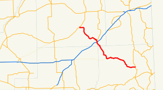
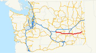
State Route 26 (SR 26) is a state highway in central Washington in the United States. It travels east–west for 114 miles (183 km) from Interstate 90 (I-90) near Vantage to U.S. Route 195 (US 195) in Colfax. The highway intersects several major north–south highways, including SR 24, SR 17, US 395, and SR 261 before ending in Colfax. The route serves as a connector between Vantage, Royal City, Othello, Washtucna, La Crosse, and Colfax.
State Route 181 is a 6.05-mile-long (9.74 km) state highway serving King County in the U.S. state of Washington. The highway, travelling north parallel to the Green River, begins at SR 516 in Kent and ends at an interchange with Interstate 405 (I-405) in Tukwila. The highway primarily serves as an alternate route to the SR 167 freeway, which travels east parallel to SR 181.
State Route 502 is a 6.12-mile-long (9.85 km) state highway in the U.S. state of Washington, serving the city of Battle Ground in Clark County. The highway travels due east from an interchange with Interstate 5 (I-5) north of Mount Vista through Dollars Corner and Battle Ground to an intersection with SR 503, serving as connector between Battle Ground and I-5. Prior to the 1964 highway renumbering, SR 502 was part of Secondary State Highway 1S (SSH 1S), which was established in 1937. The highway traveled south from its current western terminus until the construction of a new interchange with I-5 in 2008, part of a project to widen SR 502 and install a median barrier on the roadway.
State Route 508 (SR 508) is a 32.84-mile (52.85 km) long state highway located in Lewis County within the U.S. state of Washington, extending from an interchange with Interstate 5 (I-5) concurrent with U.S. Route 12 (US 12) in Napavine to SR 7 in Morton. By 1916, a road between Napavine and Cinebar was constructed on the current route of SR 508 and was signed in 1937 as Secondary State Highway 5K (SSH 5K) after being extended to Morton. SSH 5K became SR 508 in 1968 and since then, a segment in Bear Canyon has been reconstructed twice between 2007 and 2009 and a bridge over the Tilton River was reconstructed in 2009.
State Route 516 (SR 516) is a 16.49-mile-long (26.54 km) state highway in the U.S. state of Washington, serving communities in southern King County. The highway travels east as the Kent-Des Moines Road and the Kent-Kangley Road from a concurrency with SR 509 in Des Moines through Kent and Covington to an intersection with SR 169 in Maple Valley. SR 516, designated as part of the National Highway System within Kent, intersects three major freeways in the area: Interstate 5 (I-5) in western Kent, SR 167 in downtown Kent, and SR 18 in Covington. The roadway, built in the 1890s, was codified in 1937 as Secondary State Highway 1K (SSH 1K) from Des Moines to Kent and SSH 5A from Kent to Maple Valley. The two highways were combined during the 1964 highway renumbering to form SR 516 on its current route.
Primary State Highway 6 (PSH 6) was a Washington state highway in the older primary and secondary system that existed from 1937 until 1964 in Spokane and Pend Oreille counties. The road ran from an intersection with PSH 3, U.S. Route 2 and US 395 in Spokane north to British Columbia Highway 6 (BC 6) at the Canada–US border near Metaline Falls, passing its branch route and two secondary routes.
State Route 231 (SR 231) is a 74.97-mile (120.65 km) long state highway in the U.S. state of Washington serving communities in Lincoln and Stevens counties. The highway, located entirely west of Spokane in the Inland Empire, serves Sprague, Edwall, Reardan, Springdale and Chewelah. The route extends from SR 23 north of Sprague to a concurrency with U.S. Route 2 (US 2) near Reardan and an intersection with US 395 south of Chewelah.
State Route 174 (SR 174) is a 40.66-mile (65.44 km) long state highway that traverses Douglas, Grant and Lincoln counties in Washington. SR 174 begins at a junction with SR 17 in Leahy and travels eastward to Grand Coulee, near the Grand Coulee Dam, to intersect SR 155. From Grand Coulee, the roadway travels southeast to end at SR 21 northwest of Wilbur.
State Route 211 (SR 211) is a Washington state highway located in Pend Oreille County. The 15.18-mile (24.43 km) long route that begins at an intersection with U.S. Route 2 (US 2) east of Diamond Lake. The highway extends north to end at SR 20 in Usk, a small community south of Cusick. The roadway serves as a bypass of Newport. The route originally was established as Secondary State Highway 6B (SSH 6B) in 1937. SSH 6B was later renumbered to SR 311 in 1964 during the highway renumbering. After SR 20 was extended east over SR 31, the highway was renumbered to SR 211.
State Route 140 (SR 140) was a state highway located in Clark and Skamania counties in southwestern Washington. The highway began and ended at SR 14 in Washougal and Prindle, respectively, and followed the Washougal River and Canyon Creek. The roadway first appeared as Canyon Creek Road in a 1911 map and was designated Secondary State Highway 8B (SSH 8B) in 1937. SSH 8B was a spur route of Primary State Highway 8 (PSH 8), which became SR 12 in the 1964 highway renumbering. SR 120 replaced SSH 8B in the same renumbering and SR 12 was renumbered in 1967 to SR 14 after U.S. Route 12 was extended into Washington. SR 120 was also renumbered to SR 140, which was decommissioned in 1992.