Seetal

Last updated
The Seetal valley, with Lake Baldegg in the middle ground and the Alps behind 2012-08-28 Regiono Seetal (Foto Dietrich Michael Weidmann) 174.JPG
The Seetal valley, with Lake Baldegg in the middle ground and the Alps behind
Lake Hallwil Halwiler see02.jpg
Lake Hallwil
Seetalstrasse and railway near Beinwil am See Beinwil am See Seetalbahn 2003-06-25 4528.jpg
Seetalstrasse and railway near Beinwil am See

The Seetal is a valley in the cantons of Lucerne and Aargau in Switzerland. The valley descends from south to north from near Eschenbach (in the canton of Lucerne) to Lenzburg (in the canton of Aargau), and is drained by the Aabach and the Ron. The valley is distinguished by Lake Hallwil and Lake Baldegg, from which it takes its name (Lake Valley). [1]

Canton of Lucerne Canton of Switzerland

The canton of Lucerne is a canton of Switzerland. It is located in the centre of Switzerland. The population of the canton is 406,506. As of 2007, the population included 57,268 foreigners, or about 15.8% of the total population. The cantonal capital is Lucerne.

Switzerland federal republic in Western Europe

Switzerland, officially the Swiss Confederation, is a country situated in western, central and southern Europe. It consists of 26 cantons, and the city of Bern is the seat of the federal authorities. The sovereign state is a federal republic bordered by Italy to the south, France to the west, Germany to the north, and Austria and Liechtenstein to the east. Switzerland is a landlocked country geographically divided between the Alps, the Swiss Plateau and the Jura, spanning a total area of 41,285 km2 (15,940 sq mi). While the Alps occupy the greater part of the territory, the Swiss population of approximately 8.5 million people is concentrated mostly on the plateau, where the largest cities are to be found: among them are the two global cities and economic centres Zürich and Geneva.

Eschenbach, Lucerne Place in Lucerne, Switzerland

Eschenbach is a municipality in the district of Hochdorf in the canton of Lucerne in Switzerland.

Contents

Communities

The following municipalities lie within the Seetal: [1]

Aesch, Lucerne Place in Lucerne, Switzerland

Aesch is a municipality in the district of Hochdorf in the canton of Lucerne in Switzerland.

Altwis Place in Lucerne, Switzerland

Altwis is a municipality in the district of Hochdorf in the canton of Lucerne in Switzerland.

Ballwil Place in Lucerne, Switzerland

Ballwil is a municipality in the district of Hochdorf in the canton of Lucerne in Switzerland.

Transport

The valley is followed throughout its length by the Seetalstrasse main road and by the Seetal railway line, which both serve to link Lucerne and Lenzburg. The railway line closely parallels the road, with many of the characteristics of a roadside tramway, and stations serve many of the villages of the valley.

Seetal railway line railway line

The Seetal railway line is a 1,435 mm (standard-gauge) railway of the Swiss Federal Railways between Lenzburg and Lucerne in Switzerland. The line was opened in 1883 by the Lake Valley of Switzerland Railway Company, which was owned by British investors, and subsequently owned by the Schweizerische Seethalbahn-Gesellschaft (SthB).

Lucerne Place in Switzerland

Lucerne is a city in central Switzerland, in the German-speaking portion of the country. Lucerne is the capital of the canton of Lucerne and part of the district of the same name. With a population of about 81,057 people, Lucerne is the most populous town in Central Switzerland, and a nexus of economics, transportation, culture, and media of this region. The city's urban area consists of 17 municipalities and towns located in three different cantons with an overall population of about 250,000 people.

Lenzburg Place in Aargau, Switzerland

Lenzburg is a town in the central region of the Swiss canton Aargau and is the capital of the Lenzburg District. The town, founded in the Middle Ages, lies in the Seetal valley, about 3 kilometres south of the Aare river. Lenzburg and the neighbouring municipalities of Niederlenz and Staufen have grown together in an agglomeration.

Related Research Articles

Canton of Aargau Canton of Switzerland

The canton of Aargau is one of the more northerly cantons of Switzerland. It is situated by the lower course of the Aare, which is why the canton is called Aar-gau. It is one of the most densely populated regions of Switzerland.

Beinwil am See Place in Aargau, Switzerland

Beinwil am See is a municipality in the district of Kulm in the canton of Aargau in Switzerland.

Kulm District is a district in the canton of Aargau, Switzerland. It is located west of Lake Hallwil and covers parts of the Wyna and Suhre valleys. The principal town is Unterkulm; the largest municipality is Reinach. The district contains 17 municipalities, is 101.35 km² in area and has a population of 41,029.

Lake Hallwil lake in Switzerland

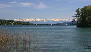
Lake Hallwil is a lake largely in the Canton of Aargau, Switzerland, located at 47°17′N8°12′E. It is the largest lake in Aargau and lies mostly in the districts of Lenzburg and Kulm on the southern edge of the canton. The southern tip of the lake reaches into the canton of Lucerne. The main river leading to this lake is the Aabach, which is coming from the Lake Baldegg.

Boniswil Place in Aargau, Switzerland

Boniswil is a municipality in the district of Lenzburg in the canton of Aargau in Switzerland.

Hallwil Place in Aargau, Switzerland

Hallwil is a municipality in the district of Lenzburg in the canton of Aargau in Switzerland.

Seengen Place in Aargau, Switzerland

Seengen is a municipality in the district of Lenzburg in the canton of Aargau in Switzerland.

The Sarner Aa is a 28 km (17 mi) long river in the Swiss canton of Obwalden. It drains the area to the eastern side of the Brünig Pass, flowing through the Lake Lungern, Lake Sarnen and the Wichelsee, before entering Lake Lucerne near Alpnach. It goes by several names over its length, being known as the Lauibach upstream of the Lungerersee, and the Aa or Aawasser between the Lungerersee and Lake Sarnen.

Egelsee (Aargau) lake at Bergdietikon, Aargau, Switzerland

Egelsee is a lake at Bergdietikon, Aargau, Switzerland. Its surface area is 2 ha. It is the largest natural lake that lies entirely in the canton.

Wyna (river) river in Switzerland

The Wyna is a river located mostly in canton of Aargau, but also in canton of Lucerne, Switzerland and runs through the Wynetal. It is a tributary of the Suhre. The Wyna is 32 km long. Larger towns in Wynetal are Beromünster, Menziken, Reinach (AG) and Gränichen.

Wynental and Suhrental Railway railway line in northern Switzerland

The Wynental and Suhrental Railway is a privately owned narrow gauge railway company in the canton of Aargau in Switzerland. It operates under the brand Aargau Verkehr AG (AVA), together with the BDWM Transport

Suhre river in Switzerland

The river Suhre is a 34 kilometer long tributary of the river Aare in the Swiss cantons of Lucerne and Aargau. The river rises in Sempachersee at an altitude of 504 meters above sea level, and joins the Aare east of the town Aarau at an altitude of 362 meters. The most important side valley is the Ruedertal, which joins the Suhretal at Schöftland.

Aabach (Seetal) river in Switzerland

The Aabach is a small river that runs through the Swiss cantons of Lucerne and Aargau, in the Aare catchment area. It flows from south to north through the valley called Seetal and ends in the Aare.

Lindenberg (Switzerland) mountain in Switzerland

The Lindenberg, peaking at 878 m, is a wooded hill in the Swiss Plateau north of the Alps, situated between the valleys of the Aabach, the Bünz and the Reuss. The hill draws a straight north-south line. On his ridge lies the border between the cantons of Lucerne and Aargau. Although the highest peak lies in the canton of Lucerne in the municipality of Müswangen, around 75% of the hill lies in the Aargau. The highest point is unspectacular as it is very flat and wooded; it can be reached by foot, by bike or even by jeep. Despite being overgrown with large forests and fields, many villages are situated on the hill's slopes and at its base, some of the bigger are Muri AG, Sins, Hochdorf and Hitzkirch. The hill is a frequently used place for bikers, hikers, equestrians and families, as several restaurants exist on various places of the hill. Despite his low altitude for Swiss standards, at some points the view is quite a sight as Lake Zug, Lake Hallwil and Lake Baldegg and prominent Swiss mountains as Säntis, Tödi, Titlis and Finsteraarhorn can be seen from some places, like Horben.

Lenzburg railway station railway station

Lenzburg is a railway station in the municipality of Lenzburg in the Swiss canton of Aargau.

Trostburg Castle

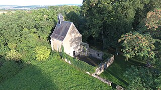
Trostburg Castle is a small castle in the municipality of Teufenthal in the canton of Aargau in Switzerland.

The Heitersberg Railway (Heitersbergstrecke) is a Swiss railway line between the stations of Killwangen-Spreitenbach and Aarau on the east-west main line between Zürich und Bern. The main structure of the line is the 4,929 metre-long Heitersberg Tunnel, which has its west portal near Mellingen and its east portal near Killwangen.

The Zofingen–Wettingen railway is a standard-gauge line in Switzerland. It was opened on 6 September 1877 between Zofingen and Baden Oberstadt together with the Aarau–Suhr railway by the Swiss National Railway. The opening of the adjacent Baden Oberstadt–Wettingen section together with the Wettingen–Effretikon railway, which represented its continuation to the east, was delayed until 15 October 1877 due to construction delays at the Limmat bridge. The SNB went bankrupt in 1878, after which the line was acquired by the Swiss Northeastern Railway from the bankrupt estate. The NOB became part of the Swiss Federal Railways with the nationalisation of the company in 1902.

References

  1. 1 2 map.geo.admin.ch (Map). Swiss Confederation. Retrieved 2012-05-02.

Coordinates: 47°13′54″N8°14′37″E / 47.23167°N 8.24361°E / 47.23167; 8.24361

Geographic coordinate system Coordinate system

A geographic coordinate system is a coordinate system that enables every location on Earth to be specified by a set of numbers, letters or symbols. The coordinates are often chosen such that one of the numbers represents a vertical position and two or three of the numbers represent a horizontal position; alternatively, a geographic position may be expressed in a combined three-dimensional Cartesian vector. A common choice of coordinates is latitude, longitude and elevation. To specify a location on a plane requires a map projection.