
East Godavari district or Toorpu Godavari Jilla is a district in Coastal Andhra region of Andhra Pradesh, India. Its district headquarters is at Kakinada. As of Census 2011, it became the most populous district of the state with a population of 5,151,549. Rajahmundry and Kakinada are the two largest cities in the Godavari districts in terms of population.
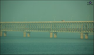
Rajamahendravaram, is a city in the Indian state of Andhra Pradesh located on the banks of the Godavari River in East Godavari district. It is a municipal corporation and also the headquarters of both Rajahmundry Rural and Rajahmundry Urban mandals, administered under Rajahmundry revenue division. As of 2018 census, it is the fifth most populous city in the state, with a population of 540,825.

West Godavari district or Paschima Godavari Jilla is one of the 13 districts in the Indian state of Andhra Pradesh. The district is situated in Coastal Andhra region of the state. The administrative headquarters of the district is situated at Eluru. As of 2011 census of India, the district has an area of 7,742 km2 (2,989 sq mi) and a population of 3,936,966. It is bounded by Krishna district on the west, East Godavari district on the east, Bay of Bengal on the south and the state of Telangana on the north.

Palakollu is the administrative headquarters of Palakollu Mandal in Narasapuram revenue division in West Godavari district of the Indian state of Andhra Pradesh. Palakollu is situated in Coastal Andhra region of the state. Occupying 19.49 square kilometres (7.53 sq mi) As of 2011 census, it has a population of about 61.2 kilo and a Metro population of about 81.1 kilo, making it the fourth most populous city in West Godavari District in Andhra pradesh. Palakollu City was selected for the year 2015-16 Housing for All Under Pradhan Mantri Awas Yojana for house less poor in the urban areas. At an average altitude of 1.5 metres (4.9 ft), Palakollu city is situated on National Highway 165 (India) and National Highway 216 (India) It is bounded by Krishna district on the west, East Godavari district on the east, Bay of Bengal on the south and the state of Telangana on the north. which is home to Ksheerarama, one of the five great Pancharama Kshetras.

Dowleswaram is a part of Rajahmundry Municipal Corporation in East Godavari district of the Indian state of Andhra Pradesh. It was a census town as per 2011 Census of India and was fully included into the corporation on 18 March 2013, along with 21 panchayats. It also forms a part of Godavari Urban Development Authority.
Mandapeta also called as Mandavyapuram is a town and A-grade municipality in East Godavari district in the India state of Andhra Pradesh. It is an market for many villages near It is famous for rice mills and for many famous leaders.

Rampachodavaram is a census town in East Godavari district of the Indian state of Andhra Pradesh. It is located in Rampachodavaram mandal of Rampachodavaram revenue division.

Atreyapuram is a village in East Godavari district of Indian state of Andhra Pradesh. It is located in Atreyapuram mandal of Amalapuram revenue division of the district.

Thallarevu is a hamlet of Polekurru in East Godavari district of the Indian state of Andhra Pradesh. Its name literally mean ferry of toddy palm trees. It is located in Thallarevu mandal of Kakinada revenue division.
Kakinada (rural) mandal is one of the 59 mandals in East Godavari of the state of Andhra Pradesh, India. It has its headquarters at Kakinada. The mandal is bounded by Samalkota mandal, Pedapudi mandal, Karapa mandal, Kothapalle mandal and waters of Bay of Bengal.
Rajahmundry (rural) is one of the 59 mandals in East Godavari district of the state of Andhra Pradesh, India. It has its headquarters at Rajahmundry. The mandal is bounded by Seethanagaram mandal, Korukonda mandal, Rajanagaram mandal, Kadiam mandal and Atreyapuram mandal.
Ganapavaram is a village in West Godavari district of the Indian state of Andhra Pradesh.
Bommuru is a part of Rajahmundry Municipal Corporation in East Godavari district of the Indian state of Andhra Pradesh. It was an Out growth to the corporation, as per 2011 census of India and was fully included into the corporation on 18 March 2013, along with 21 panchayats. It also forms a part of Godavari Urban Development Authority.
Katheru is a part of Rajahmundry Municipal Corporation in East Godavari district of the Indian state of Andhra Pradesh. It was a census town and an urban agglomeration constituent of Rajahmundry as per 2011 census of India and was fully included into the corporation on 18 March 2013, along with 21 panchayats. It also forms a part of Godavari Urban Development Authority.
Rajahmundry (urban) mandal is one of the 59 mandals in East Godavari of the state of Andhra Pradesh, India. It has its headquarters at Rajahmundry city, that covers the entire urban mandal. The mandal is surrounded by Rajahmundry (rural) mandal and lies on the banks of Godavari River.
Ballipadu is a village in West Godavari District of Andhra Pradesh, India. It is located in the Thallapudi mandal of Andhra region. It is located 86 km towards east from District headquarters Eluru.

Biccavolu mandal is one of the 65 mandals in East Godavari district of the Indian state of Andhra Pradesh. It is under the administration of Rajahmundry revenue division and the headquarters are located at Biccavolu village. Biccavolu Mandal is bounded by Rayavaram Mandal towards South, Pedapudi Mandal towards East, Anaparthy Mandal towards west, Ramachandrapuram Mandal towards north. It is located ata distance of 41 kilometres from Rajahhmundry.
Chintalapudi mandal is one of the 46 mandals in West Godavari district of the Indian state of Andhra Pradesh. It is administered under Eluru revenue division and its headquarters are located at Chintalapudi. The mandal is bounded by T.Narasapuram mandal, Lingapalem mandal, Khammam district


