The Black Forest is a large forested mountain range in the state of Baden-Württemberg in southwest Germany, bounded by the Rhine Valley to the west and south and close to the borders with France and Switzerland. It is the source of the Danube and Neckar rivers.
Tuttlingen is a Landkreis (district) in the south of Baden-Württemberg, Germany. Neighboring districts are Rottweil, Zollernalbkreis, Sigmaringen, Constance and Schwarzwald-Baar.

Haslach im Kinzigtal is a small city in the Black Forest in the district Ortenaukreis, Baden-Württemberg in south-western Germany. In 2015, it comprised a population of 6,893 inhabitants.
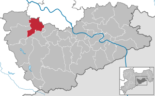
Freital is a town in the district of Sächsische Schweiz-Osterzgebirge in Saxony, Germany. The town is situated on a small river, the Weißeritz, and is eight kilometres (5 mi) southwest of Dresden.

The Münstertal is a municipality in the southern Black Forest, which belongs to the district of Breisgau-Hochschwarzwald in Baden-Württemberg in southern Germany. It is 3 miles east from Staufen.

Within the Lower Harz region are still many traces of the historical water management facilities used by the mining industry. In addition to water-carrying ditches and ponds, there are also long-abandoned ditches and dry pond beds. The Lower Harz Pond and Ditch System, which forms the major part of these old water management facilities, lies in the central Lower Harz, almost entirely within the borough of the present-day town of Harzgerode.
The Hüttenstollen, also Straßberger Hüttenstollen, was the central drainage adit in the Straßberg mining field and was also part of the Lower Harz Pond and Ditch System in the Harz Mountains of Germany. The adit lies at a depth of 50 m and is 750 m long. The pit water was drained into the Selke. The drainage ditches were the Straßberger Flösse and the Stollgraben.
The lachter was a common unit of length used in the mining industry in Europe, usually to measure depth, tunnel driving and the size of mining fields; it was also used for contract work. In most German-speaking mining fields it was the most important unit of length.
Drei Kronen & Ehrt is a former mine in the Harz Mountains of central Germany. It is located in the parish of Elbingerode in the county of Harz (Saxony-Anhalt). The mine extracted pyrite. Since 1992 it has been used, albeit not continuously, as a visitor mine.

The German Mining Museum in Bochum or DBM is one of the most visited museums in Germany with around 365,700 visitors per year (2012). It is the largest mining museum in the world, and a renowned research establishment for mining history.

Stolberg Zinc joint-stock company for mining and smelter operations in Aachen, or Stolberg Zinc Mines GmbH, is a metal mining concern in the Aachen region and specifically in the area of Eschweiler-Stolberg, with headquarters in Stolberg.

The Deep Tunnel is an adit at Hercherhof near Freiburg, Germany. It is a part of the Schauinsland mine complex and was built for the Stolberg Zink AG to provide easier access to the seventh floor level of the Roggenbergschacht mine. Construction began in 1938. It was termed part of the Four Year Plan, an economic plan designed to prepare Nazi Germany for war, and Hermann Göring's name was invoked in a dispute between the mining company and the state environmental protection agency when the agency requested the greening of excavated material.

The Black Forest Costume Museum is a museum in the convent building of the former Capuchin abbey in Haslach im Kinzigtal in the Baden-Württemberg county of Ortenaukreis in south Germany.

The Grünhirscher Stollen is an adit for water drainage in Sankt Andreasberg, in the Harz mountains. It was created during mining in the Upper Harz and named after the valley Grüner Hirsch between the mountains Galgenberg and Glockenberg. It leads from the Samson Pit to the south-west of the Galgenberg.
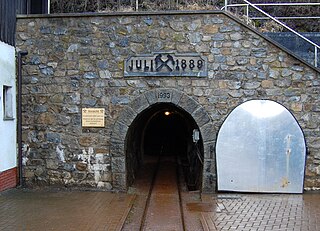
The Schauinsland Pit was a silver and lead mine east of Freiburg im Breisgau. From the 19th century zinc was also mined. The mine operated from the 13th century until 1954. Since 1997 Schauinsland Pit has been a show mine.

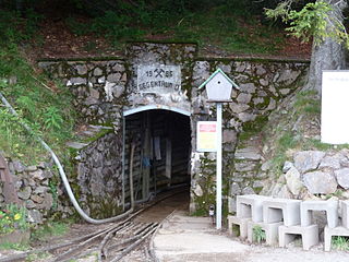
The Finstergrund Pit near Wieden in the Black Forest in Germany is an abandoned medieval silver and lead mine that was also used in the modern era to extract fluorite and baryte. Since 1982 it has been used as a visitor mine.

The Caroline Pit in the Eberbächle, a side valley of the Brettenbach, is an old silver mine in Sexau in the Black Forest in Germany which is open to the public as a show mine. In 1987, volunteers began to uncover the pit and maintain it. It lies within the mining region of Sexau and Freiamt.
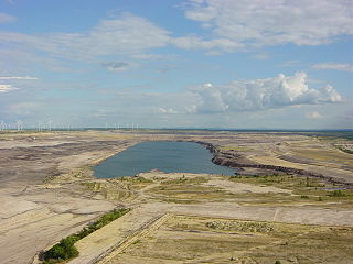
The Bergheider See, south of Finsterwalde near Lichterfeld in the county of Elbe-Elster in Germany, is a flooded pit from the former open cast mine of Klettwitz-Nord, northeast of the Lower Lusatian Heath. The lake was named after the old village of Bergheide, which had to be abandoned for the brown coal pit.

The Silbergründle Pit near Seebach in the Black Forest in Germany was a lead and silver mine.

The area around Wiesloch, Germany, is a historical centre for mining, running between Roman times and the earlier 2000s. The area is situated on the eastern edge of the Upper Rhine Plain and contains large concentrations of carbonate-hosted lead-zinc ore deposits. Lime for cement is still actively mined in the vicinity, with most of the clay pits closed, and the last heavy metal mine operated until 1953 by Stolberger Zink. On top of the escarpment metals and lime have been mined, with clay and sand mined at the end of the valley floor where faulting has brought different layers closer to the surface.