The Black Forest is a large forested mountain range in the state of Baden-Württemberg in southwest Germany, bounded by the Rhine Valley to the west and south and close to the borders with France and Switzerland. It is the source of the Danube and Neckar rivers.

The Schauinsland is a mountain in the Black Forest with an elevation of 1,284 m (4,213 ft) above sea level. It is a popular destination for day trips. Due to the high amount of silver mining, it was previously known as "Erzkasten" ; the name "Schouwesland" first appeared in 1347. The mountain is located roughly ten kilometres south-east of Freiburg's city centre.

Altenau ( ) is a town and a former municipality in the district of Goslar, in Lower Saxony, Germany. Since 1 January 2015 it is part of the town Clausthal-Zellerfeld.

The Münstertal is a municipality in the southern Black Forest, which belongs to the district of Breisgau-Hochschwarzwald in Baden-Württemberg in southern Germany. It is 3 miles east from Staufen.

The Upper Harz Water Regale is a system of dams, reservoirs, ditches and other structures, much of which was built from the 16th to 19th centuries to divert and store the water that drove the water wheels of the mines in the Upper Harz region of Germany. The term regale, here, refers to the granting of royal privileges or rights in this case to permit the use of water for mining operations in the Harz mountains of Germany.

Mining in the Upper Harz region of central Germany was a major industry for several centuries, especially for the production of silver, lead, copper, and, latterly, zinc as well. Great wealth was accumulated from the mining of silver from the 16th to the 19th centuries, as well as from important technical inventions. The centre of the mining industry was the group of seven Upper Harz mining towns of Clausthal, Zellerfeld, Sankt Andreasberg, Wildemann, Grund, Lautenthal und Altenau.

The Augustiner Museum is a museum in Freiburg im Breisgau, Germany located in the former Augustinian Monastery building. It is undergoing an extensive renovation and expansion, the first phase of which ended in 2010.
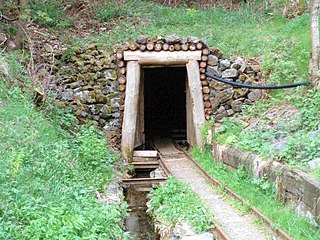
The Roter Bär Pit in Sankt Andreasberg in the Upper Harz is an iron ore mine that was worked from about 1800 until the 1860s. Today it is operated as a show mine under the name of Roter Bär Pit Educational Mine by the Sankt Andreasberg Society for History and Archaeology. The name Roter Bär means "Red Bear".

The Mooskappe is an old, traditional miners head covering. It was intended to protect miners when working underground from the impact of small rockfalls and from hitting their heads against the gallery roof (Firste). The term is German and this type of hat was worn especially in the Harz Mountains of Germany.
A Pinge or Binge ("binger") is the name given in German-speaking Europe to a wedge-, ditch- or funnel-shaped depression in the terrain caused by mining activity. This depression or sink-hole is frequently caused by the collapse of old underground mine workings that are close to the Earth's surface. Unlike natural landforms, a Pinge is a direct result of human activity. The term has no direct equivalent in English, but may be translated as "mining sink-hole", "mine slump" or, in some cases, as "glory hole".

The Deep Tunnel is an adit at Hercherhof near Freiburg, Germany. It is a part of the Schauinsland mine complex and was built for the Stolberg Zink AG to provide easier access to the seventh floor level of the Roggenbergschacht mine. Construction began in 1938. It construction was part of the Four Year Plan, an economic plan designed to prepare Nazi Germany for war, and Hermann Göring's name was invoked in a dispute between the mining company and the state environmental protection agency when the agency requested the greening of excavated material.

The Maaßener Gaipel is a pub catering for day trippers on the northeastern hillside of the Kranichsberg at a height of 420 m above NN, situated above the mining town of Lautenthal in the Harz Mountains of central Germany. The name goes back to the above-ground workings of the Maaßener Treibschacht or Maaßen Hoisting Shaft 51°51′49″N10°17′25″E, which was located immediately east of the inn. Gaipel is a common expression in the Upper Harz for a headframe and goes back to the use of a horse whim which in German is a Pferdegöpel. Whims were used to transport men and materiel up and down mineshafts, for example using man engines, and also to operate water management equipment. Maaßen is shorthand for the name of the local pit which was the Grube Zweite, Dritte, Vierte, Fünfte und Sechste Maß nach der Sachsenzeche. Maaß, also variously spelt Maaß, Maas or Mas, is a unit of length for a pit field (Grubenfeld) and in mining in the Upper Harz measured 28 Lachter or 53.8 metres. The pub was built in 1924 on the initiative of the Harz Club on the terrain of the old mine shaft. But decades before the area had already become a popular destination with walkers due to its views of the mining town and the valley of the Laute.

The Finstergrund Pit near Wieden in the Black Forest in Germany is an abandoned medieval silver and lead mine that was also used in the modern era to extract fluorite and baryte. Since 1982 it has been used as a visitor mine.

The Caroline Pit in the Eberbächle, a side valley of the Brettenbach, is an old silver mine in Sexau in the Black Forest in Germany which is open to the public as a show mine. In 1987, volunteers began to uncover the pit and maintain it. It lies within the mining region of Sexau and Freiamt.

The Segen Gottes Show Mine is a show mine in the parish of Schnellingen in the municipality of Haslach in the Central Black Forest in Germany.

The Silbergründle Pit near Seebach in the Black Forest in Germany was a lead and silver mine.
Walter Salmen was a German musicologist and university lecturer. Salmen taught from 1958 to 1992 as a professor of musicology at the Saarland University and the University of Kiel. Afterwards, he was for many years the full professor of the Musicological Institute of the University of Innsbruck. As a guest lecturer, he also worked in Switzerland, Israel and the United States. After retirement, he lived in Kirchzarten near Freiburg im Breisgau, and worked as honorary professor at the University of Freiburg.
Walther Rehm was a German literary scholar.
Karl Heinrich Kaufhold was a German economic historian. He worked for the University of Göttingen.
Matthias Untermann is a German art historian and medieval archaeologist.