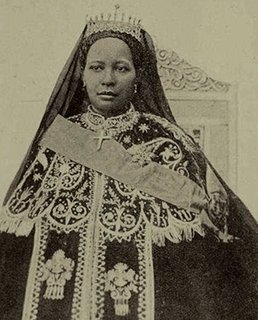
Zewditu was Empress of Ethiopia from 1916 to 1930. The first female head of an internationally recognized country in Africa in the 19th and 20th centuries, and the first empress regnant of the Ethiopian Empire, her reign was noted for the reforms of her Regent and designated heir Ras Tafari Makonnen, about which she was at best ambivalent and often stridently opposed, due to her staunch conservatism and strong religious devotion. She is the most recent empress regnant in Ethiopian history, and the last female head of state until the 2018 election of Sahle-Work Zewde as president.
Ankober, formerly known as Ankobar, is a town in central Ethiopia. Located in the North Shewa Zone of the Amhara Region, it's perched on the eastern escarpment of the Ethiopian Highlands at an elevation of about 2,465 meters (8,100 ft). It is 40 kilometers (25 mi) to the east of Debre Birhan and about 90 miles (140 km) northeast of Addis Ababa.
Amba Mariam is a village in central Ethiopia. It was known as Magdala or Makdala during the reign of Emperor Tewodros II (1855-1868). Located in the Debub Wollo Zone of the Amhara Region, Amba Mariam has a longitude and latitude of 11°12′N39°17′E.

Johann Ludwig Krapf was a German missionary in East Africa, as well as an explorer, linguist, and traveler. Krapf played an important role in exploring East Africa with Johannes Rebmann. They were the first Europeans to see Mount Kenya with the help of Akamba who dwelled at its slopes and Kilimanjaro. Ludwig Krapf visited UKAMBANI in 1849 and again in 1850 and successfully translated the new testament to KIKAMBA. Krapf also played a key role in exploring the East African coastline especially in Mombasa.

Debre Tabor is a town and woreda in north-central Ethiopia. Located in the Debub Gondar Zone of the Amhara Region, about 100 kilometers southeast of Gondar and 50 kilometers east of Lake Tana, this historic town has a latitude and longitude of 11°51′N38°1′E with an elevation of 2,706 metres (8,878 ft) above sea level. The presence of at least 48 springs in the area contributed to the development of Debre Tabor.

Until the end of the Ethiopian monarchy in 1974, there were two categories of nobility in Ethiopia and Eritrea. The Mesafint, the hereditary nobility, formed the upper echelon of the ruling class. The Mekwanint were the appointed nobles, often of humble birth, who formed the bulk of the aristocracy. Until the 20th century, the most powerful people at court were generally members of the Mekwanint appointed by the monarch, while regionally, the Mesafint enjoyed greater influence and power. Emperor Haile Selassie greatly curtailed the power of the Mesafint to the benefit of the Mekwanint, who by then were essentially coterminous with the Ethiopian government.
Kidane Kale, better known as Abuye, was a Meridazmach of Shewa, an important Amhara noble of Ethiopia. He was the son of Sebestyanos. Abir states that he ruled for 25 years, although noting that William Cornwallis Harris claims he ruled for 15 years, Coulbeaux for 25, and Rochet d'Hericourt for 60. His wife was Woizero Tagunestiya, daughter of Mama Rufa'el, Governor of Mamameder.
Wossen Seged was a Merid Azmach of Shewa, an Amhara noble of Ethiopia He was the elder son of Asfa Wossen, by a woman of the Solomonic dynasty. He was the first ruler of Shewa to claim a higher title than Merid Azmach, calling himself Ras.
Sahle Selassie was a ruler and later King of Shewa from 1813 to 1847. An important Amhara noble of Ethiopia, he was a younger son of Wossen Seged. Sahle Selassie was the father of numerous sons, among them Haile Melekot, Haile Mikael, Seyfe Sahle Selassie, Amarkegne and Darge Sahle Selassie; his daughters included Tenagnework, Ayahilush, Wossenyelesh, Birkinesh, and Tinfelesh.
Woizero Zenebework was the wife of Wossen Seged, Merid Azmach of Shewa; the mother of Negus Sahle Selassie, the first Negus of Shewa; the grandmother of Negus Haile Melekot of Shewa; and the great-grandmother of Emperor Menelik II. Woizero Zenebework held the powerful districts of Menz and Tegulet as her personal fiefs.
Were Ilu, or Bete Giyorgis, is a woreda in Amhara Region, Ethiopia. This woreda is named for one of the subgroups of the Wollo Oromo that used to govern the area and is still located there. Part of the Debub Wollo Zone, Were Ilu is bordered on the southwest by Jama, on the west by Legahida, on the northwest by Legambo, on the north by Dessie Zuria, on the east by the Abuko, and on the southeast by the Wanchet which separates it from the Semien Shewa Zone. Towns in Were Ilu include Kabe, Were Ilu and Weyin Amba; a historic landmark is Mekane Selassie, the site of a medieval church destroyed. The woreda of Legahida was separated from Were Ilu.
Moretna Jeru is one of the woredas in the Amhara Region of Ethiopia. It is named in part after the historic district of Shewa, Moret, which lay between the Jamma River and the district of Shewa Meda. Part of the Semien Shewa Zone, Moretna Jeru is bordered on the south by Siyadebrina Wayu, on the south west by Ensaro, on the northwest by Merhabiete, on the northeast by Menz Keya Gebreal, and on the east by Basona Werana. The administrative center of this woreda is Enewari; other towns in Moretna Jeru include Jihur.
The Jamma River is a river in central Ethiopia and a tributary of the Abay on its right side. It drains parts of the Semien Shewa Zones of the Amhara and Oromia Regions. The Upper Jamma flows through steep, deep canyons cut first through volcanic rock and then through the Cretaceous sandstone and shaly sandstone, with Jurassic limestone at the bottom. It has a drainage area of about 15,782 square kilometers in size. Tributaries include the Wanchet.
Tenta is a town in northern Ethiopia. Located in the Debub Wollo Zone of the Amhara Region, Tenta has a latitude and longitude of 11°19′N39°15′E with an elevation of 2,972 meters (9,751 ft) above sea level. It is one of three towns in Tenta woreda.
The Journals of the Rev. Messrs. Isenberg and Krapf, Missionaries of the Church Missionary Society, Detailing their proceedings in the kingdom of Shoa, and journeys in other parts of Abyssinia, in the years 1839, 1840, 1841 and 1842 is an 1843 journal published in 1843 at London. It contains the geographical memoir of the eastern part of the continent Africa, and most day by day events that took place in the original time of their happening. It is associated with the missionary works of Carl Wilhelm Isenberg and Johann Ludwig Krapf of the Church Missionary Society, and their encounter with the yet poorly known kingdom of Shewa in Ethiopia.
Marra Biete is a former province of Ethiopia, located inside the boundaries of the modern Semien Shewa Zone of the Amhara Region, north of Shewa Meda.
Ancharo also known as Curcureta is a town in northern Ethiopia. Located in the Debub Wollo Zone of the Amhara Region, Ancharo has a latitude and longitude of 11°03′N39°47′E with an elevation of 2972 meters above sea level. It is one of four towns in Kalu woreda.
RasLul Seged Atnafseged, also known by his horse name Abba Balay, was an Ethiopian courtier and army commander under the Emperor Menelik II. A key figure in late 19th and early 20th century, he was responsible for several successful military campaigns, but was killed in battle during the struggle over Menelik's succession.
Bulga is a former historical region of Ethiopia in the central part of Shewa. It was bounded by the Germama river to the south, which formed the historical boundary between it and Minjar in the south. It presently encompasses the modern woredas of Hagere Mariamna Kesem, Asagirt, and Berehet.
Garmame and Horse name: Abba Mala was an influential 19th century Ethiopian counsellor, governor and a military commander with the title of Dejazmach. Garmame is remembered for his leading role in rescuing Menelik II and other notables from captivity in July 1865, and restoring the Shewan heir back to the throne. In May 1877 he prevented a coup concocted by Bafena, and solidified the position of his Negus. After retirement from military activities, Garmame governed large tracts of fertile land south of Ankober, and is also remembered for his role in providing relief to the people during the disastrous 1890's famine'.
